
You watch the full changes here: Poland’s Territorial Changes 1635-Present – Life, Death & Rebirth.
Here’s another view:

In the early 17th century, the Polish-Lithuanian Commonwealth was one of the largest and most populous countries in Europe, comprising about 1,000,000 km2 (390,000 sq mi) of land with a population of some 12 000 000 people (5m Ruthenians, 4.5m Poles, 0.75m Lithuanians, 0.75m Prussians, 0.5m Jews and 0.5m Livionians).
As can be seen on the map, the Commonwealth’s territory was – in terms of present-day borders – equal to: most of Poland and Ukraine; all of Belarus, Lithuania, Latvia and the Kaliningrad Oblast; much of Estonia; parts of Russia (including Smoleńsk); as well as small parts of Moldova and Romania.
Over the next centuries, it experienced a series of invasions, wars, and internal strife that weakened the state.
Between 1772 and 1795, Poland was partitioned three times by its powerful neighbors—Russia, Prussia, and Austria—erasing it from the map.
Poland regained independence after World War I in 1918.
However, during World War II, it was invaded by Nazi Germany and the Soviet Union, leading to occupation and devastation.
After World War II, Poland’s borders shifted westward by approximately 200 kilometres (about 124 miles).
The new borders, drawn at the Yalta and Potsdam Conferences, meant Poland lost about 179,000 square kilometres (69,000 square miles) of territory in the east, which was incorporated into the Soviet Union.
To compensate, Poland gained about 101,000 square kilometres (39,000 square miles) of formerly German land to the west, including cities like Wrocław (Breslau), Szczecin (Stettin), and Gdańsk (Danzig).
This westward shift was substantial, pushing Poland’s center of gravity closer to the Oder-Neisse line, which became its new western boundary.
This border change displaced millions of people, as ethnic Poles were relocated from the east to the newly acquired western territories, and Germans were expelled westward into what remained of Germany.
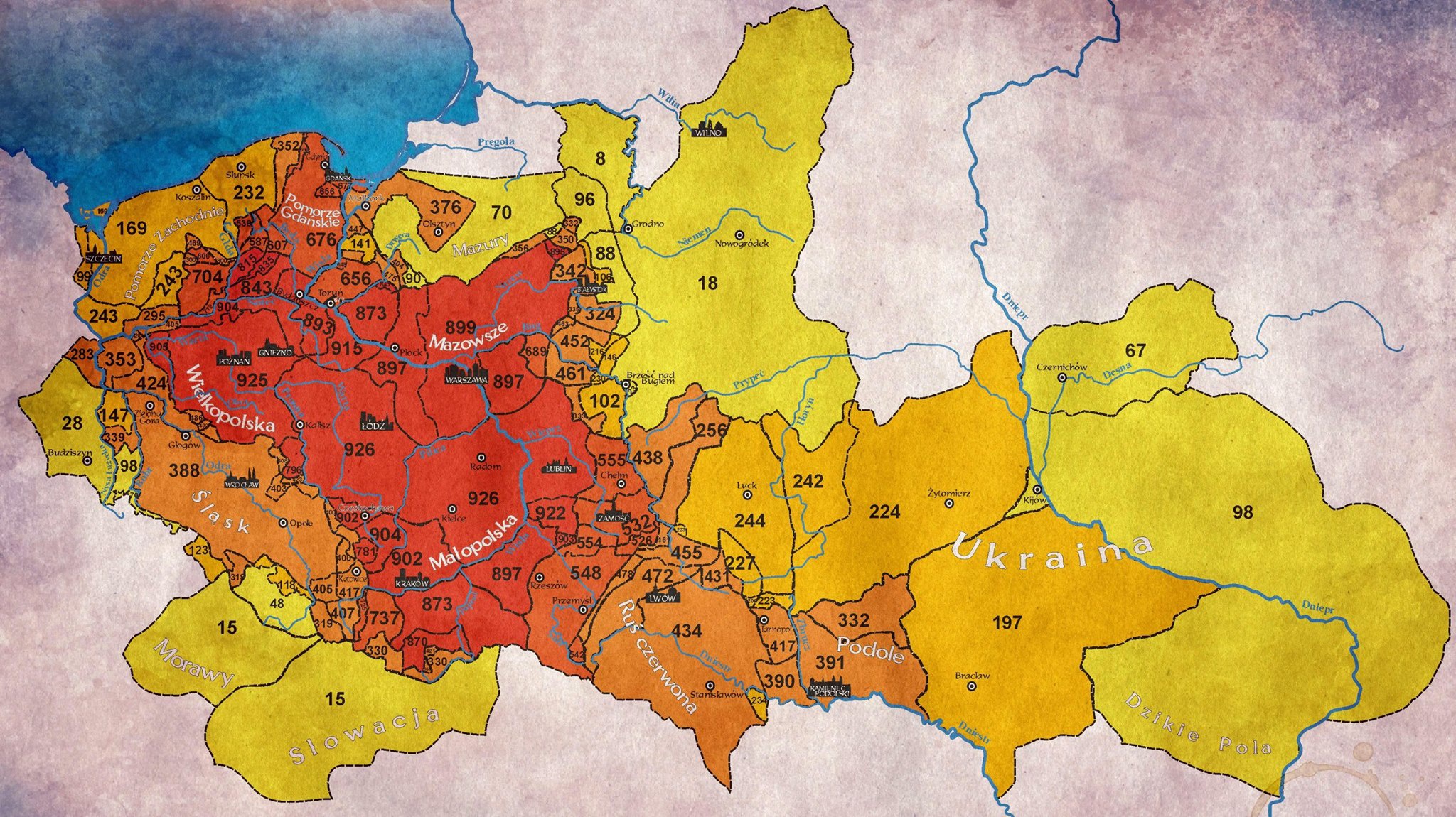
Finally, below you can see map showing For how many years was X territory a part of Poland


Y.D. Robinson says
Western post-1945 Poland (essentially Pomerania and Silesia) was occupied by Western Slavic, proto-Polish tribes before the Holy Roman Empire (essentially Germany’s predecessor) expanded eastwards and assimilated most if not all of those tribes into the German language and culture. Thus, before World War II, Pomerania and Silesia were just about every bit as German as the area right to the west that would be East Germany during the Cold War.
Most of northeast post-1945 Poland was also German for centuries beforehand, and was occupied by Old Prussians, ethnic/linguistic relatives of the Lithuanians and Latvians, before they, too, were assimilated by the incoming Germans centuries ago.
Thus, the map and areal extent of post-1945 Poland says relatively little about pre-1945 Poland except in an area stretching from Poznan in the west to Lodz, Warsaw, Krakow, Lublin, Bialystok, etc. further east. (Even more so than the likes of Romania and Hungary, which also changed territorially but have kept more of their core without gaining much new territory not belonging historically to their namesake ethnic groups.)
Andy says
This year will be the 1,000 year anniversary of Boleslaw the Great crowning as the first king of Poland. The present borders of the Polish Republic are very close to those the Polish Kingdom had at that time. Enough said! Creeping German political and cultural expansion to the east over the centuries does not mean much today.
jeff says
i have 4 grandparents that moved from poland to the US around 1900. what is the likelihood that my DNA includes that of populations such as ukraine. they were from areas around krakow.