
This map shows the territorial acquisitions of the United States, highlighting how the nation expanded over time through various treaties, purchases, and annexations.
Here are the key territorial acquisitions mentioned on the map:
- Territory of the Original Thirteen States (Ceded by Great Britain 1783):
- The original thirteen colonies gained independence from Great Britain after the American Revolutionary War, officially recognized by the Treaty of Paris in 1783.
- Louisiana Purchase (1803, from France):
- The U.S. purchased a vast territory from France, doubling the size of the nation. This land includes parts or all of 15 current U.S. states and two Canadian provinces.
- British Cession (1818):
- This involved settling boundary issues and land claims between the U.S. and Great Britain, affecting areas of the northern Midwest and parts of the current U.S.-Canada border.
- Spanish Cession (1819):
- Spain ceded Florida and other claims east of the Mississippi River to the U.S. through the Adams-Onís Treaty.
- Texas Annexation (1845, formerly Republic of Texas):
- Texas, which had declared independence from Mexico in 1836, was annexed by the U.S. and became the 28th state.
- Oregon Territory (Treaty with Great Britain 1846):
- The Oregon Treaty settled the boundary dispute between the U.S. and Great Britain, establishing the 49th parallel as the border between the U.S. and British North America (Canada).
- Mexican Cession (1848):
- Following the Mexican-American War, Mexico ceded a large portion of its northern territories to the U.S. in the Treaty of Guadalupe Hidalgo. This included present-day California, Nevada, Utah, Arizona, New Mexico, and parts of Colorado and Wyoming.
- Gadsden Purchase (1853, from Mexico):
- The U.S. purchased land from Mexico to facilitate the construction of a southern transcontinental railroad. This area is now part of southern Arizona and New Mexico.
- Alaska Purchase (1867, from Russia):
- The U.S. bought Alaska from Russia, adding a significant amount of territory to the northwest of the continent.
- Hawaiian Annexation (1898, formerly Republic of Hawaii):
- The U.S. annexed Hawaii, which had been an independent republic since the overthrow of the Kingdom of Hawaii in 1893.
- Spanish Cession (1898):
- As a result of the Spanish-American War, Spain ceded Puerto Rico, Guam, and the Philippines to the U.S. (though the Philippines later gained independence in 1946).
- Virgin Islands Purchased from Denmark (1917):
- The U.S. purchased the Virgin Islands from Denmark, adding to its Caribbean territories.
Want something a bit more detailed? then watch this video
Animated Map Showing The Detailed Territorial Growth Of The United States Over 249 Years
Of you can watch the faster version here:
And finally here is a map showing US land purchases both in the original price and inflation adjusted 2026 value:
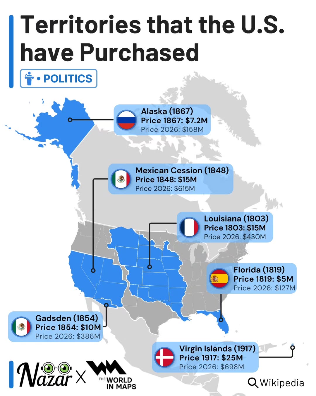
U.S. Territorial Purchases (Chronological Order)
- Louisiana Purchase (1803)
- Original price (1803): $15 million
- Inflation-adjusted price (2026): $430 million
- Florida (Adams–Onís Treaty, 1819)
- Original price (1819): $5 million
- Inflation-adjusted price (2026): $127 million
- Mexican Cession (1848)
- Original price (1848): $15 million
- Inflation-adjusted price (2026): $615 million
- Gadsden Purchase (1854)
- Original price (1854): $10 million
- Inflation-adjusted price (2026): $386 million
- Alaska Purchase (1867)
- Original price (1867): $7.2 million
- Inflation-adjusted price (2026): $158 million
- U.S. Virgin Islands (1917)
- Original price (1917): $25 million
- Inflation-adjusted price (2026): $698 million
What do you think?


Thomas Ungricht says
There seems to be a typo in the headline: Aquations -> Acquisitions
Brilliant Maps says
Good catch, updating now
°ŞIUg$~4~Br€@kfAsT° says
Putin is a monster for retrieving Crimea and other peripheral nations, building a stronger Russia – exactly as the United States did.
Thomas Kinne says
That means that Denmark is the country that made the best deal so far (both in total 2026 dollars and in dollars per area). The USVI have an area of 346 km², Greenland has 2,166,086 km². At a purchase price of roughly 2 million USD (2026) per square kilometer, Greenland should be worth at least 4.3 trillion USD. That’s about 10 times the GDP of Denmark.