In modern times, the term seven seas is synonymous with the seven oceans of the world: Arctic, North Atlantic, South Atlantic, North Pacific, South Pacific, Indian, and Southern oceans.
However, that has not always been the case.
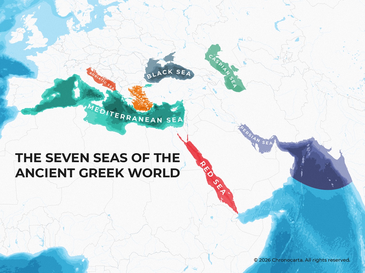
The 3 maps below created by reddit user DwizKhalifa show how the term seven seas has been used by different people at different times.
Seven Seas According To The Ancient Greeks

According to the ancient Greeks the Seven Seas were:
On the map:
- Mediterranean Sea
- Adriatic Sea
- Black Sea
- Caspian Sea
- Red Sea
- Persian Gulf
- Arabian Sea
Ranked by Approximate modern day Surface Area (Largest to Smallest)
- Arabian Sea: ~3,860,000 km²
- Mediterranean Sea: ~2,500,000 km²
- Red Sea: ~438,000 km²
- Black Sea: ~436,000 km²
- Caspian Sea: ~371,000 km²
- Persian Gulf: ~251,000 km²
- Adriatic Sea: ~139,000 km²
An Alternative map:
Seven Seas According To Arabian Sources

According to the Arabs the Seven Seas were:
The seven seas as labeled on the map are:
- Persian Gulf
- Arabian Sea
- Bay of Bengal
- Strait of Malacca
- Singapore Strait
- Gulf of Thailand
- South China Sea
Ranked by Approximate Modern-Day Surface Area (Largest to Smallest)
- Arabian Sea: ~3,860,000 km²
- South China Sea: ~3,500,000 km²
- Bay of Bengal: ~2,170,000 km²
- Gulf of Thailand: ~320,000 km²
- Persian Gulf: ~251,000 km²
- Strait of Malacca: ~65,000 km²*
- Singapore Strait: *Significantly smaller than the others*
*Note: Straits are usually measured by length and average width rather than total surface area. Figures above are approximate references.
Seven Seas According To Medieval Europeans

And finally according to the medieval Europeans:
The seven seas as labeled on the map are:
- Baltic Sea
- North Sea
- Atlantic Ocean
- Mediterranean Sea
- Black Sea
- Red Sea
- Arabian Sea
Ranked by Approximate Modern-Day Surface Area (Largest to Smallest)
- Atlantic Ocean: ~106,000,000 km²
- Arabian Sea: ~3,860,000 km²
- Mediterranean Sea: ~2,500,000 km²
- North Sea: ~750,000 km²
- Red Sea: ~438,000 km²
- Black Sea: ~436,000 km²
- Baltic Sea: ~377,000 km²
Note: The “Atlantic” here is counted as one of the Seven Seas (as it was in many medieval European accounts), although it is an ocean. Modern surface-area figures are approximate.
And finally, in case you were wondering about the sources used for these maps DwizKhalifa has you coverd:
Here’s one that covers quite a few iterations of “the Seven Seas,” and I find the Wikipedia article helpful especially for elaborating on the Arabian list (including a pretty interesting excerpt). Another source can be found here (which, as a another redditor pointed out, is one of several I found that has a slightly different list for Greek sources), but I ended up drawing from this one by the Library of Congress.
Of course, most of these pages themselves just say, “Greek literature” and whatnot. But the justification for that level of broadness is that, well, these three lists in particular were so commonly given in literature of their time and place that there is no one single “source” to cite from the periods in question. They were, seemingly, nearly ubiquitously acknowledged in their cultures. Which is why it’s all the more interesting to me that there still arised such a diversity of lists over the ages in spite of that.
What do you think?
![Map Of The Growth of The US From 1607 to 2022 [Video]](https://brilliantmaps.com/wp-content/uploads/maxresdefault-4-300x200.jpg)



Leave a Reply