
Here’s what the British Antarctic Survey has to say about temperatures:
Around the coasts of Antarctica, temperatures are generally close to freezing in the summer (December-February) months, or even slightly positive in the northern part of the Antarctic Peninsula.
During winter, monthly mean temperatures at coastal stations are between -10°C and -30°C but temperatures may briefly rise towards freezing when winter storms bring warm air towards the Antarctic coast.
Conditions on the high interior plateau are much colder as a result of its higher elevation, higher latitude and greater distance from the ocean.
Here, summer temperatures struggle to get above -20°C and monthly means fall below -60°C in winter. Vostok station holds the record for the lowest ever temperature recorded at the surface of the Earth (-89.2°C).
And here’s what Sasha has to say about his map:
Antarctica—0.00008 people per sq. km!
McMurdo is by far the largest community on Antarctica with 1200 people in the summer and 250 in the winter. It’s located at the southernmost ice pack-free point on the continent.
King George Island is home to a dozen smaller stations whose populations add up. In many cases the stations are so close to one another that they are basically one community (e.g. Fildes Peninsula).
I made this map by getting station populations from Wikipedia (or in some cases other sources), then just joining them to a grid (unequal area, based on the polar orthographic projection) and plotting the centroids of those joined grid cells.
I learned about Antarctic oases, areas that are inexplicably free of ice and snow. Looks a lot like Death Valley, only 120º F colder: https://en.wikipedia.org/wiki/Antarctic_oasis
So what are all these people doing?
Here’s what people typically do in Antarctica:
1. Scientific Research
- Climate Studies: Scientists study climate change by analyzing ice cores, atmosphere, and sea ice.
- Glaciology: Research focuses on the ice sheets, glaciers, and their impact on global sea levels.
- Biology: Some study the unique ecosystems, including wildlife like penguins, seals, and microorganisms.
- Astronomy: The clear skies and minimal light pollution provide a unique vantage for space research.
- Geology: Researchers study the continent’s geological history to understand plate tectonics and past climates.
- Oceanography: The Southern Ocean around Antarctica is a major area for marine science.
2. Support Roles
- Logistics and Infrastructure: There are many support staff (e.g., mechanics, electricians, chefs, and doctors) ensuring that the research stations function.
- Pilots and Ship Crews: Pilots fly planes to transport supplies, and ships bring in goods from other continents.
3. Tourism (Limited)
- A small number of tourists visit each year, mainly during the summer, to see wildlife, glaciers, and icebergs. Most arrive via cruise ships, and the activity is strictly regulated to minimize environmental impact.
4. International Collaboration
- Antarctica is governed by the Antarctic Treaty, which ensures it is used for peaceful and scientific purposes. People work together from various nations in this spirit of cooperation.
5. Extreme Environment Experience
- The extreme cold, isolation, and unique environment offer opportunities to train for space exploration or prepare for survival in harsh conditions.
Which European countries have research stations?
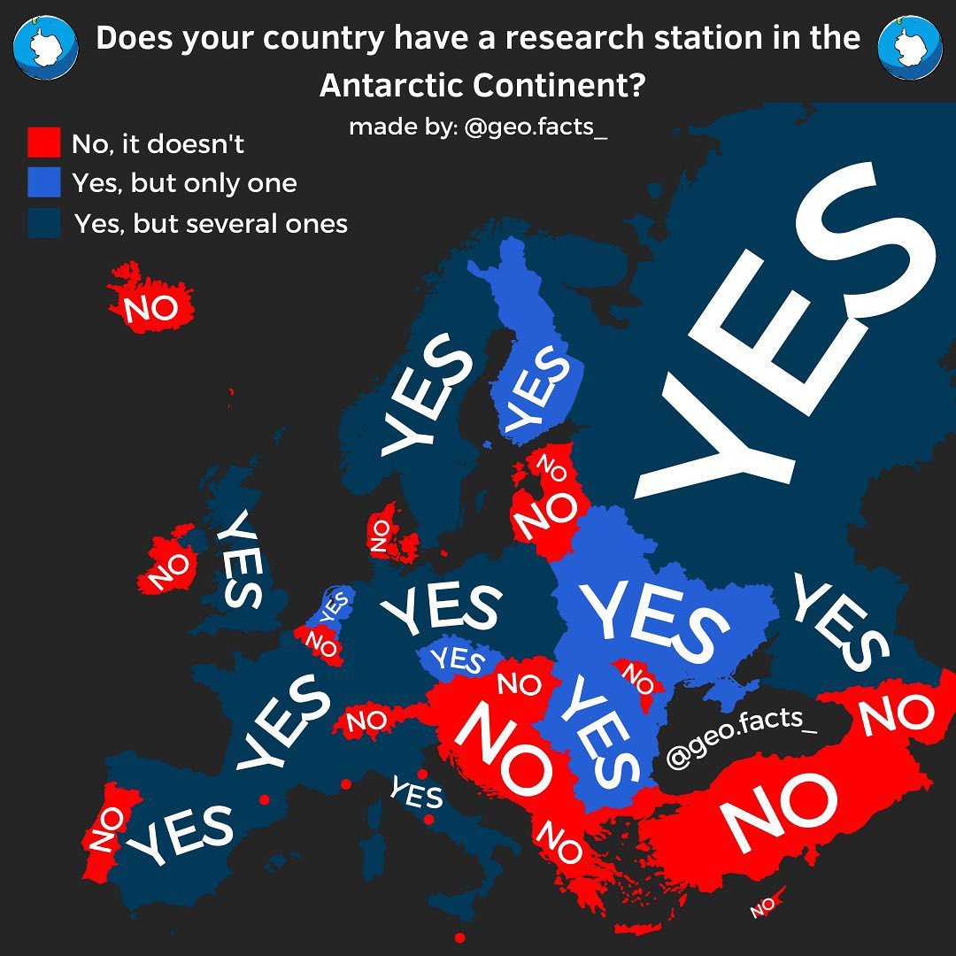
Would you want to live there?


François says
Belgium does have a research station on the Antarctic continent:
https://en.wikipedia.org/wiki/Princess_Elisabeth_Antarctica