Brilliant Maps

Making Sense Of The World, One Map At A Time

  • BOOK!
  • Newsletter
  • Board Games
  • Posters
  • Scratch Maps

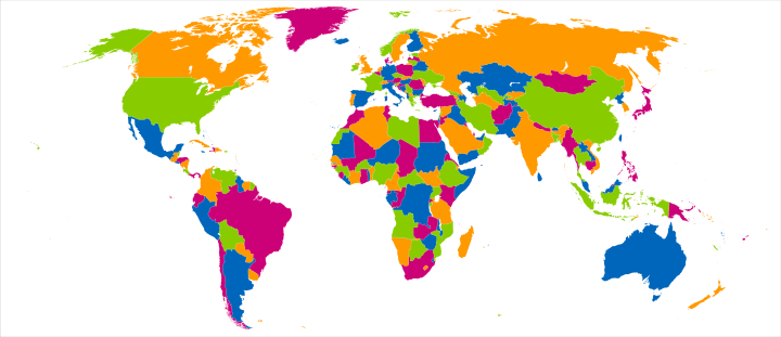
4 Colour Theorem: All The World’s Countries Can Be Coloured Using Only 4 Colours, So That No Two Adjacent Countries Share The Same Colour

Last Updated: March 3, 2023 4 Comments

4 Colour Theorem: All The World's Countries Can Be Coloured Using Only 4 Colours So That No Two Adjacent Countries Have The Same Colour

Map created by Fibonacci on Wikimedia

The map shows the four colour theorem in practice.

The theorm states that:

… given any separation of a plane into contiguous regions, producing a figure called a map, no more than four colors are required to color the regions of the map so that no two adjacent regions have the same color. Adjacent means that two regions share a common boundary curve segment, not merely a corner where three or more regions meet.

In actual, fact the map uses 5 colours, if you include the white used for the oceans, although it would still technically be possible to draw a world map using only 4 colours, if landlocked countries shared the same colour as the ocean.

Want to read more on the subject? The good news is that there’s a surprising number of books about it:

  • Four Colors Suffice: How the Map Problem Was Solved
  • The Four-Color Theorem: History, Topological Foundations, and Idea of Proof
  • The Four Colour Theorem
  • Graphs, Colourings and the Four-Colour Theorem

Enjoy this map? Please help by sharing it:
Filed Under: World Maps

Get Our Latest Brilliant Maps Weekly:


Other Popular Maps

  • Interactive Pangaea Map With Modern International Borders

    Interactive Pangaea Map With Modern International Borders

  • The British Empire At Its Territorial Peak Covered Nearly The Same Area As The Moon

    The British Empire At Its Territorial Peak Covered Nearly The Same Area As The Moon

  • Most Common Country of Origin of New Immigrants To The United States

    Most Common Country of Origin of New Immigrants To The United States

  • Map Of The Town of Springfield From The Simpsons

    Map Of The Town of Springfield From The Simpsons

  • Climate Analogues of Australia

    Climate Analogues of Australia

  • Dispersion of Syrian Refugees Around Europe

    Dispersion of Syrian Refugees Around Europe

  • Where You Can & Can’t Flush Toilet Paper Around The World

    Where You Can & Can’t Flush Toilet Paper Around The World

  • The World’s Population In 1900 Looked Very Different Than Today

    The World’s Population In 1900 Looked Very Different Than Today

Comments

  1. Will Bishop says

    April 28, 2018 at 11:38 pm

    The four-color theorem does not prove that the world map can be four-colored, because some countries consist of non-contiguous regions (like the U.S., Russia, and Azerbaijan). It happens to work out anyway due to the placement of those countries.

    Reply
  2. PabloExpox says

    May 3, 2018 at 4:30 pm

    Certainly. It was and with me. We can communicate on this theme.

    Reply
  3. Jo says

    March 5, 2022 at 10:15 am

    Disgusting map. It even shows Taiwan is part of China. I don’t know how much you have received from the Chinese gov to design such a misleading and disgusting map.

    Reply
  4. Max says

    May 3, 2023 at 10:49 am

    Good stuff, it doesn’t show written company’s all over it

    Reply

Leave a Reply Cancel reply

Your email address will not be published. Required fields are marked *

This site uses Akismet to reduce spam. Learn how your comment data is processed.


World Atlas · Settlers of Catan · Risk · Game of Thrones · Coloring Books · Globes
Monopoly · Star Wars · Game of Life · Pandemic · Ticket To Ride · Drinks Cabinets
Copyright © 2023 · Privacy Policy · Fair Use, Attribution & Copyright · Contact Us
Follow Us: E-mail · Youtube · Twitter · Facebook · Pinterest · Flipboard