Brilliant Maps

Making Sense Of The World, One Map At A Time

  • BOOK!
  • Newsletter
  • Board Games
  • Posters
  • Scratch Maps

Map of World in George Orwell’s 1984

Last Updated: August 7, 2024 Leave a Comment

Click To Get My 10 Best Brilliant Maps For Free:

Map of World in George Orwell's 1984

Map found on reddit
The map above shows the 3 major powers in George Orwell’s 1984.

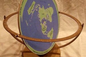
In the novel, the world is divided into three superstates:

  1. Oceania (represented by the INGSOC symbol) – This superstate includes the Americas, the British Isles, Australia, and Southern Africa. The symbol of INGSOC (English Socialism) is a blend of totalitarian symbols, emphasizing the Party’s control over this region.
  2. Eurasia (represented by the hammer and sickle within a star) – This superstate covers most of continental Europe and Russia. Its symbol suggests a fusion of Soviet and Nazi iconography, reflecting the totalitarian nature of its government.
  3. Eastasia (represented by the Asian wheel symbol) – This superstate includes China, Japan, Korea, and parts of Southeast Asia. The symbol is indicative of a different type of totalitarian regime compared to the other superstates.

Disputed Territories: The gray areas on the map represent regions that are constantly fought over by the three superstates. These regions serve as perpetual war zones, maintaining the state of constant conflict described in the book.

Filed Under: Fictional

Click To Get My 10 Best Brilliant Maps For Free:


Other Popular Maps

  • Cheek-Kissing As A Form Of Greeting Including The Number Of Kisses Given

    Cheek-Kissing As A Form Of Greeting Including The Number Of Kisses Given

  • Did you Know There Are “Rogue Holes” In The Ocean In Addition To “Rogue Waves”

    Did you Know There Are “Rogue Holes” In The Ocean In Addition To “Rogue Waves”

  • Nova Scotia (aka New Scotland) vs Scotland

    Nova Scotia (aka New Scotland) vs Scotland

  • The American King-Crane Commission Plan To Divide The Ottoman Empire After World War 1

    The American King-Crane Commission Plan To Divide The Ottoman Empire After World War 1

  • Number of CzechPOINTs In Every European Country

    Number of CzechPOINTs In Every European Country

  • Map Of The Proposed Great Green Wall Of Africa

    Map Of The Proposed Great Green Wall Of Africa

  • African Countries That Have Issued An Official Apology For Selling Captives Into The Trans-Atlantic Slave Trade

    African Countries That Have Issued An Official Apology For Selling Captives Into The Trans-Atlantic Slave Trade

  • European Food According to Italians

    European Food According to Italians

Leave a Reply Cancel reply

Your email address will not be published. Required fields are marked *

This site uses Akismet to reduce spam. Learn how your comment data is processed.


Product Reviews · World Atlas · Settlers of Catan · Risk · Game of Thrones · Coloring Books
Globes · Monopoly · Star Wars · Game of Life · Pandemic · Ticket To Ride · Drinks Cabinets
US Locations · UK Locations· Fleet Management
Copyright © 2026 · Privacy Policy · Fair Use, Attribution & Copyright · Contact Us
Follow Us: Newsletter · Facebook · Youtube · Twitter · Threads · BlueSky · LinkedIn · Instagram · Pinterest · Flipboard