Brilliant Maps

Making Sense Of The World, One Map At A Time

  • BOOK!
  • Newsletter
  • Board Games
  • Posters
  • Scratch Maps

Watch World War I Every Day On The Western Front [Video]

Last Updated: December 8, 2025 Leave a Comment

Click To Get My 10 Best Brilliant Maps For Free:

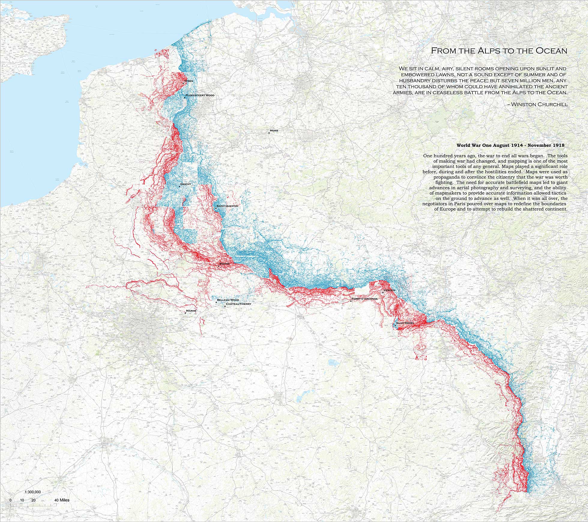
The very impressive video above was created by Miran Božičević and shows everyday of the Western Front in World War I. (You can watch the all of World War 1 here.)

Focusing on:

Troop positions and movements 1 August 1914 – 28 February 1919, 4 days every second.

Red – Germans & German allies
Blue – French & colonial infantry
Cyan – French cavalry
Orange – British & colonials
Green – Belgians in the north; Russians, Italians, Portuguese elsewhere
Purple – US-Americans

Dark blue – reserve
Light blue – resting & training
Uneven brown – building defense works
Uneven grey – staging
Solid grey – sanitation

Maps source: Cartographie 1914 – 1918, http://www.carto1418.fr/.

The video shows the front lines, leaving out the regions further south. About 85% of the overall map area is included, and the source graphics are rendered at a 60% zoom at the highest video resolution. The infobox and the date labels are redrawn in a consistent format across all frames, closely based on the original. The credit for producing the maps goes to Jean Michel Martin, the author of the Cartographie 1914 – 1918 website.

You can watch the same video at different zoom levels and sections on this playlist.

You can also watch a sped up version below:

And finally here’s a map of all the Trenches from WW1 from the Harvard Library Collection:

Map showing extent of WW1 trench movement between Aug 1914 and Nov 1918

Filed Under: War

Click To Get My 10 Best Brilliant Maps For Free:


Other Popular Maps

  • What do you call a small piece of wood under the skin? (1950s vs 2016)

    What do you call a small piece of wood under the skin? (1950s vs 2016)

  • Maps of Showing The Fonts Used In Tourism Board Logos In Europe, Asia & The US

    Maps of Showing The Fonts Used In Tourism Board Logos In Europe, Asia & The US

  • The Colour of Buses In The UK & Ireland

    The Colour of Buses In The UK & Ireland

  • Climate Analogues of Australia

    Climate Analogues of Australia

  • Change In Percentage Of Indian Households with Toilets From 2014 to 2017

    Change In Percentage Of Indian Households with Toilets From 2014 to 2017

  • The Incredible Growth Of EV Fast Charging Network Along The US Interstate Highways

    The Incredible Growth Of EV Fast Charging Network Along The US Interstate Highways

  • Percentage of Homes With Air Conditioning Around The World

    Percentage of Homes With Air Conditioning Around The World

  • South North America vs North South America

    South North America vs North South America

Leave a Reply Cancel reply

Your email address will not be published. Required fields are marked *

This site uses Akismet to reduce spam. Learn how your comment data is processed.


Product Reviews · World Atlas · Settlers of Catan · Risk · Game of Thrones · Coloring Books
Globes · Monopoly · Star Wars · Game of Life · Pandemic · Ticket To Ride · Drinks Cabinets
US Locations · UK Locations· Fleet Management
Copyright © 2026 · Privacy Policy · Fair Use, Attribution & Copyright · Contact Us
Follow Us: Newsletter · Facebook · Youtube · Twitter · Threads · BlueSky · LinkedIn · Instagram · Pinterest · Flipboard