Brilliant Maps

Making Sense Of The World, One Map At A Time

  • BOOK!
  • Newsletter
  • Board Games
  • Posters
  • Scratch Maps

Beautiful Geological Map of North America Showing Bedrock Ages

Last Updated: March 3, 2023 Leave a Comment

Click To Get My 10 Best Brilliant Maps For Free:

NA bedrock

Map created by U.S. Geological Survey

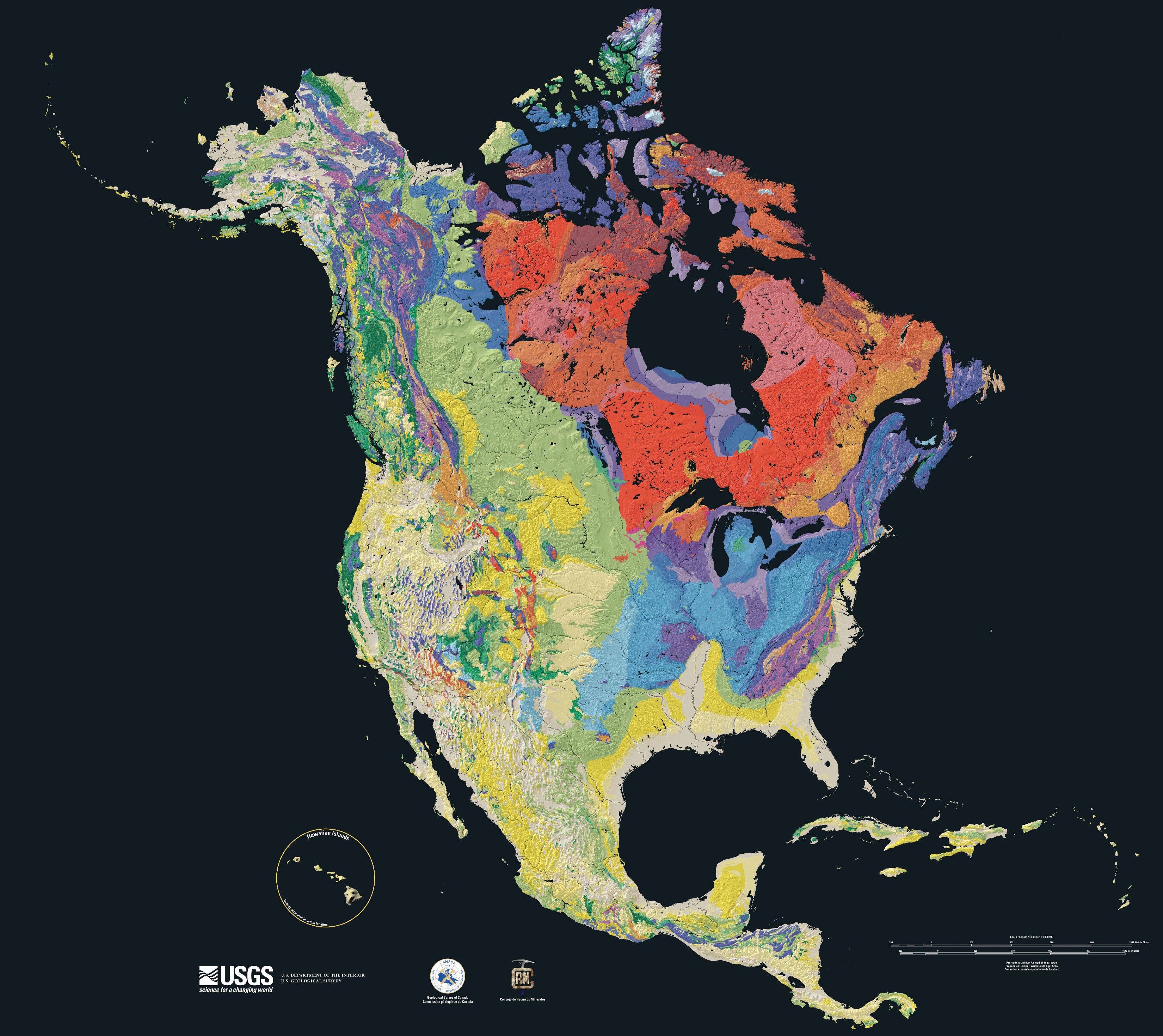
The map above shows the ages of bedrock in North America from yellow (youngest) to green to blue to red (oldest). The maps official name is the The North America Tapestry of Time and Terrain.

It was created by Kate E. Barton, David G. Howell, José F. Vigil on behalf of the the U.S. Geological Survey in collaboration with the Geological Survey of Canada and the Mexican Consejo Recursos de Minerales.

Here’s the geologic timescales:

North American geologic timescale

So even yellow bedrock may be 66 million years old, whereas the oldest could be over 4 billion years old!

From the abstract:

This cartographic Tapestry is woven from a geologic map and a shaded relief image. This digital combination reveals the geologic history of North America through the interrelation of rock type, topography and time. Regional surface processes as well as continent-scale tectonic events are exposed in the three dimensions of space and the fourth dimension, geologic time. The large map shows the varying age of bedrock underlying North America, while four smaller maps show the distribution of four principal types of rock: sedimentary, volcanic, plutonic and metamorphic.

You can sometimes buy a copy from Amazon here.

For more see:

  • Interpretation of Geological Maps
  • Essentials of Geology
  • National Geographic Pocket Guide to Rocks and Minerals of North America
  • 101 American Geo-Sites You’ve Gotta See

Enjoy this map? Please help us by sharing it:

Filed Under: Americas Tagged With: geology

Click To Get My 10 Best Brilliant Maps For Free:


Other Popular Maps

  • Some of The More Unlikely Proposed European Unions

    Some of The More Unlikely Proposed European Unions

  • Map Of Africa in 1880: 5 Years Before the Scramble

    Map Of Africa in 1880: 5 Years Before the Scramble

  • UK v Japan High Speed Rail In 1963 vs 2025

    UK v Japan High Speed Rail In 1963 vs 2025

  • England vs Great Britain vs United Kingdom Explained

    England vs Great Britain vs United Kingdom Explained

  • Map of Austria Immediately After WW1

    Map of Austria Immediately After WW1

  • 1919 Women’s Suffrage Victory Map, Published The Year Before The Passage Of The 19th Amendment

    1919 Women’s Suffrage Victory Map, Published The Year Before The Passage Of The 19th Amendment

  • Pangaea With Current International Borders

    Pangaea With Current International Borders

  • Countries Where The Capital Is Not The Largest City

    Countries Where The Capital Is Not The Largest City

Leave a Reply Cancel reply

Your email address will not be published. Required fields are marked *

This site uses Akismet to reduce spam. Learn how your comment data is processed.


Product Reviews · World Atlas · Settlers of Catan · Risk · Game of Thrones · Coloring Books
Globes · Monopoly · Star Wars · Game of Life · Pandemic · Ticket To Ride · Drinks Cabinets
US Locations · UK Locations· Fleet Management
Copyright © 2026 · Privacy Policy · Fair Use, Attribution & Copyright · Contact Us
Follow Us: Newsletter · Facebook · Youtube · Twitter · Threads · BlueSky · LinkedIn · Instagram · Pinterest · Flipboard