The Neighbourhoods of Jerusalem
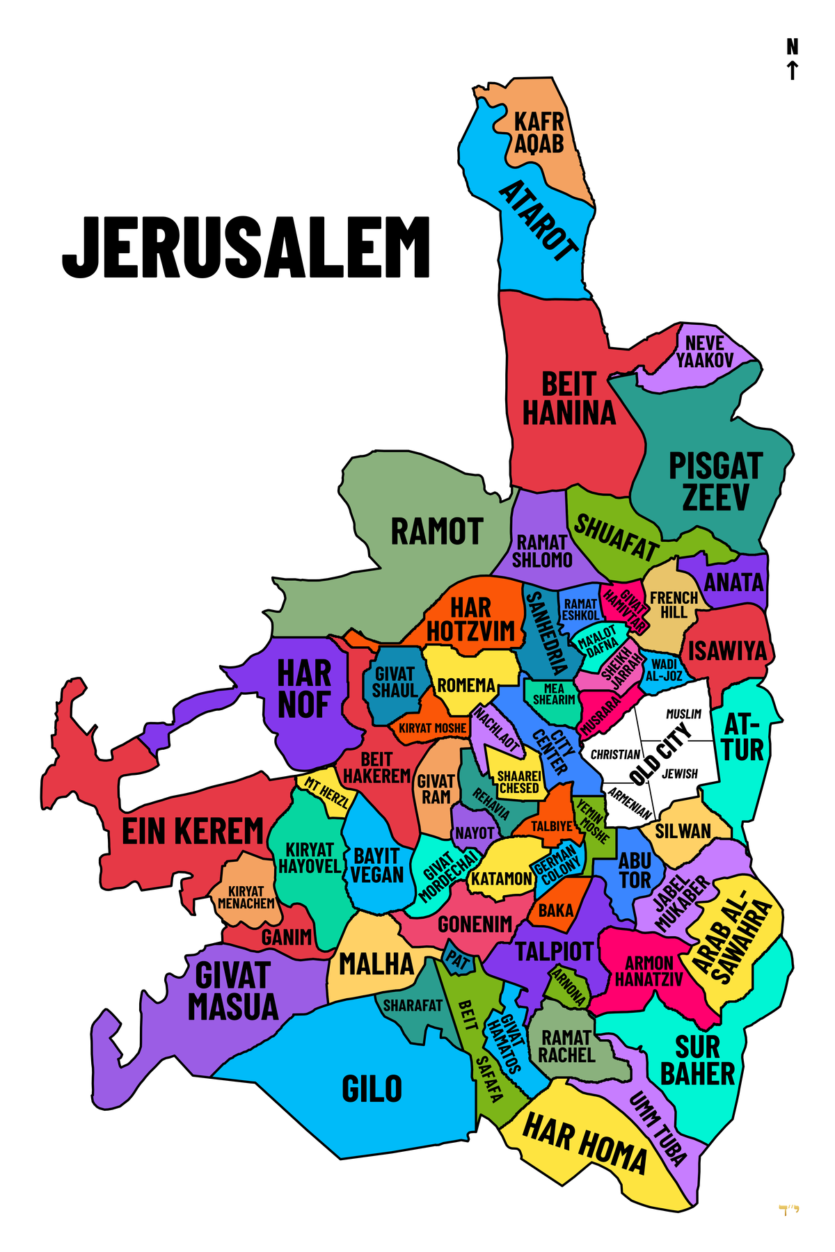
The four quarters of the Old City, followed by the 63 named neighbourhoods around it. Together with the Old City itself, that makes the 64 areas shown on the map.
The Old City quarters
The whole walled area is only 0.9 km2, with about 31,000 residents as of 2020.
- Muslim Quarter (north-east)
Both the biggest and the most populous quarter, at about 31 hectares and roughly 22,000 people. It holds Damascus Gate, the main souks and the start of the Via Dolorosa. It borders the Temple Mount / Haram al-Sharif (Al-Aqsa, Dome of the Rock), which some treat as a fifth area in its own right. - Christian Quarter (north-west)
Built around the Church of the Holy Sepulchre. It is home to the Greek Orthodox and Latin patriarchates, the Muristan market, Jaffa Gate and New Gate. - Armenian Quarter (south-west)
The smallest by population. It centres on the walled St James Cathedral and Patriarchate compound, and Armenians have been present since the 4th century. It is currently caught up in a long-running land-lease dispute (the “Cows’ Garden”). - Jewish Quarter (south-east)
Home to the Western Wall plaza, the Hurva Synagogue and the Roman Cardo. It was emptied and largely destroyed in 1948, then rebuilt after 1967, so most buildings are modern stone over excavations.
The other 63 neighbourhoods
* marks Jewish neighbourhoods built across the 1949 Green Line after 1967. Most of the world classes these as illegal settlements, a reading Israel rejects.
Far north
- Kafr Aqab: Palestinian, and cut off from the urban centre by the separation barrier despite sitting inside the municipal line. It functions as a suburb of Ramallah, with dense, unregulated high-rises.
- Atarot: An industrial zone and the disused Jerusalem (Qalandia) airport. A 9,000-unit housing plan for the site went back to planners for amendments in January 2026.
- Beit Hanina: A large, relatively affluent Palestinian neighbourhood on the Ramallah road.
- Neve Yaakov *: Founded as a Jewish village in 1924, lost in 1948, rebuilt in 1972, and now largely Haredi.
- Pisgat Zeev *: The largest Jewish neighbourhood in the city, built in the 1980s and named after Jabotinsky.
- Shuafat: A middle-class Palestinian neighbourhood on the light rail.
- Anata: Only part of the town falls inside the municipal boundary. That part is essentially the Shuafat refugee camp area, behind the barrier. It is the biblical Anathoth.
- Ramot *: A huge north-western suburb (1974) with a mixed Haredi and secular population.
- Ramat Shlomo *: A Haredi neighbourhood from the 1990s.
Inner north
- Har Hotzvim: A high-tech park (Intel, Mobileye), not residential.
- Sanhedria: Haredi, named after the Tombs of the Sanhedrin.
- Ramat Eshkol *: The first neighbourhood built over the line after 1967.
- Givat Hamivtar *: A small neighbourhood on a former Jordanian position. The remains of a crucified man were found here in 1968.
- Ma’alot Dafna *: Next to the Ammunition Hill battle site.
- French Hill *: Beside Mount Scopus and the Hebrew University, with a mixed population.
- Isawiya: A Palestinian village on Mount Scopus’s eastern slope.
- Sheikh Jarrah: Palestinian, with consulates and the American Colony Hotel. It is the site of long-running eviction cases.
- Wadi al-Joz: Palestinian, known for garages and light industry.
Centre
- City Center: Jaffa Road, Ben Yehuda Street, Zion Square and the Russian Compound.
- Musrara: Built by wealthy Arab Christians, it became a border slum after 1948 and was the birthplace of the Israeli Black Panthers. It is now arty.
- Mea Shearim: Founded in 1874, the archetypal Haredi quarter.
- Nachlaot: A warren of courtyard neighbourhoods from the 1870s onward, beside Mahane Yehuda market.
- Shaarei Chesed: Founded in 1909, religious and now very expensive.
- Rehavia: A 1920s garden suburb of German-Jewish intellectuals, with International Style architecture.
- Talbiye: Built as villas for affluent Christian Arabs. It holds the President’s Residence and the Jerusalem Theatre.
- Yemin Moshe: Home to the Montefiore windmill, beside Mishkenot Sha’ananim (1860), the first Jewish housing outside the walls.
- Romema: At the city’s western entrance, where the Ottomans surrendered in 1917.
- Kiryat Moshe: Religious Zionist, home to the Mercaz HaRav yeshiva.
- Givat Shaul: Haredi housing, an industrial zone and the Har HaMenuchot cemetery.
- Har Nof: A terraced 1980s Haredi suburb with a big English-speaking community.
- Beit Hakerem: A 1920s garden suburb, secular and middle class.
- Givat Ram: Home to the Knesset, Supreme Court, Israel Museum, National Library and a university campus.
- Nayot: A tiny 1960s enclave by the Valley of the Cross.
- Givat Mordechai: Religious Zionist, founded in the 1950s.
East
- At-Tur: On the Mount of Olives, with the Chapel of the Ascension and Augusta Victoria Hospital.
- Silwan: Palestinian, on the slope south of the walls. It holds the City of David excavations and is a major flashpoint over settler housing and demolitions.
- Abu Tor: Divided between 1948 and 1967, and still Jewish uphill and Arab downhill.
- Jabel Mukaber: Palestinian. The name is traditionally linked to Caliph Umar’s exclamation on first seeing the city.
- Arab al-Sawahra: A community of Bedouin origin, split between the municipality and the West Bank.
- Armon Hanatziv * (East Talpiot): Named after the British High Commissioner’s residence, now UN headquarters.
- Sur Baher and Umm Tuba: Adjoining Palestinian villages on the south-eastern edge.
South
- German Colony: Founded by German Templers in 1873. Its main street is the cafe strip Emek Refaim.
- Katamon: Formerly an affluent Arab neighbourhood, with a key 1948 battle at the San Simon monastery.
- Baka: Grew up around the Ottoman railway station. It is gentrified and popular with French and Anglo immigrants.
- Gonenim (the “Katamonim”): 1950s immigrant housing blocks.
- Talpiot: A 1920s garden suburb, now best known for its commercial and industrial zone.
- Arnona: The site of the US Embassy since 2018.
- Ramat Rachel: Technically a kibbutz (1926) rather than a neighbourhood, with a major Iron Age archaeological site.
- Givat Hamatos *: Long a caravan site for Ethiopian immigrants. Tenders for 1,257 homes went out in 2020 after years of frozen plans.
- Beit Safafa and Sharafat: Arab villages. Beit Safafa was cut in two by the armistice line until 1967.
- Pat: A small 1950s housing estate.
- Malha: A former Arab village, now home to the mall, Teddy Stadium, the arena and a tech park.
- Gilo *: A large hilltop suburb facing Beit Jala.
- Har Homa *: Built from 1997. Its construction triggered a crisis in the Oslo process.
West
- Ein Kerem: A village of churches, the traditional birthplace of John the Baptist, with Hadassah hospital above it.
- Mt Herzl: The national cemetery, with Yad Vashem on its slope.
- Bayit Vegan: A religious hilltop neighbourhood full of yeshivas.
- Kiryat Hayovel: A big 1950s immigrant suburb, home to the “Monster” slide sculpture.
- Kiryat Menachem and Ganim (Ir Ganim): Working-class 1950s estates.
- Givat Masua: A 1990s suburb on the south-western rim.
Sources
- Old City of Jerusalem (Wikiwand)
- Old City of Jerusalem (Surf Wiki)
- Muslim Quarter, Jerusalem (Surf Wiki)
- East Jerusalem (Wikipedia)
- The impact of the barrier on the Jerusalem area (UN OCHA)
- Shrinking space in Palestinian neighbourhoods (PASSIA)
- The Government Promotes the Plans in Atarot and Sheikh Jarrah (Peace Now)
- Israel pushing plans for thousands of homes in sensitive Jerusalem area (Israel Hayom)
- The Strategic Construction Plans in Jerusalem (JCFA)



Leave a Reply