Brilliant Maps

Making Sense Of The World, One Map At A Time

  • BOOK!
  • Newsletter
  • Board Games
  • Posters
  • Scratch Maps

Map of New-Netherland & New-Sweden Around 1650

Last Updated: October 3, 2024 Leave a Comment

Click To Get My 10 Best Brilliant Maps For Free:

Map of New-Netherland & New-Sweden Around 1650

Map found on Wikimedia
The map above shows the relative positions and sizes of two of the American colonial eras forgotten powers, New Netherland and New Sweden in around the year 1650.

Here’s a little more about each of them:

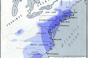
New Netherland (1609–1664)

  1. 1609 – Henry Hudson, an English explorer employed by the Dutch East India Company, explores the Hudson River and claims the region for the Dutch, leading to the establishment of New Netherland.
  2. 1624 – The Dutch West India Company formally establishes New Netherland as a colony, with settlements in the Hudson River Valley. The first settlement is Fort Orange (modern-day Albany).
  3. 1626 – Peter Minuit, the Director of New Netherland, purchases the island of Manhattan from Native Americans for trade goods. The settlement there is named New Amsterdam (modern-day New York City).
  4. 1638 – New Sweden, a Swedish colony (see below), is established on the Delaware River, encroaching on New Netherland territory.
  5. 1640s–1650s – New Netherland grows, and Dutch settlers face conflicts with Native Americans and competition with English settlers in New England. The colony also has border tensions with New Sweden.
  6. 1655 – Peter Stuyvesant, the Director-General of New Netherland, captures New Sweden and incorporates it into New Netherland.
  7. 1664 – The English, under James, Duke of York, capture New Netherland. New Amsterdam is renamed New York, and the entire colony becomes part of English territory.

New Sweden (1638–1655)

  1. 1638 – Peter Minuit, who had previously been a Dutch official, leads the establishment of New Sweden under Swedish rule. The first settlement, Fort Christina, is founded in what is now Wilmington, Delaware.
  2. 1638–1643 – The colony grows slowly with settlements along the Delaware River, trading with Native American groups, and establishing farms and outposts.
  3. 1643 – Johan Printz becomes the governor of New Sweden and expands the colony’s defenses and trading activities.
  4. 1655 – After tensions between New Netherland and New Sweden, Peter Stuyvesant leads a Dutch military expedition that successfully conquers New Sweden, which is then absorbed into New Netherland.

In 1664, when the English took over New Netherland, they also took control of what had been New Sweden.

Find this map interesting? Then please help by sharing it:


Filed Under: History

Click To Get My 10 Best Brilliant Maps For Free:


Other Popular Maps

  • Map Showing Where Presidential Assassinations (And Attempts) Have Occurred

    Map Showing Where Presidential Assassinations (And Attempts) Have Occurred

  • Mom Can We Go On An American Road Trip?

    Mom Can We Go On An American Road Trip?

  • 25 Largest Cities In The Americas By Population (Residing Within City Limits)

    25 Largest Cities In The Americas By Population (Residing Within City Limits)

  • How Do People Heat Their Homes Across The United States?

    How Do People Heat Their Homes Across The United States?

  • The Canada-US Border Is The Longest International Border In The World. Here It Is Over Europe

    The Canada-US Border Is The Longest International Border In The World. Here It Is Over Europe

  • Map Of The Republic of Texas, United States & Mexico In 1841

    Map Of The Republic of Texas, United States & Mexico In 1841

  • Map Showing How Airlines Divert Flights Around Syrian Airspace

    Map Showing How Airlines Divert Flights Around Syrian Airspace

  • Map Projections & What They Say About You

    Map Projections & What They Say About You

Leave a Reply Cancel reply

Your email address will not be published. Required fields are marked *

This site uses Akismet to reduce spam. Learn how your comment data is processed.


Product Reviews · World Atlas · Settlers of Catan · Risk · Game of Thrones · Coloring Books
Globes · Monopoly · Star Wars · Game of Life · Pandemic · Ticket To Ride · Drinks Cabinets
US Locations · UK Locations· Fleet Management
Copyright © 2026 · Privacy Policy · Fair Use, Attribution & Copyright · Contact Us
Follow Us: Newsletter · Facebook · Youtube · Twitter · Threads · BlueSky · LinkedIn · Instagram · Pinterest · Flipboard