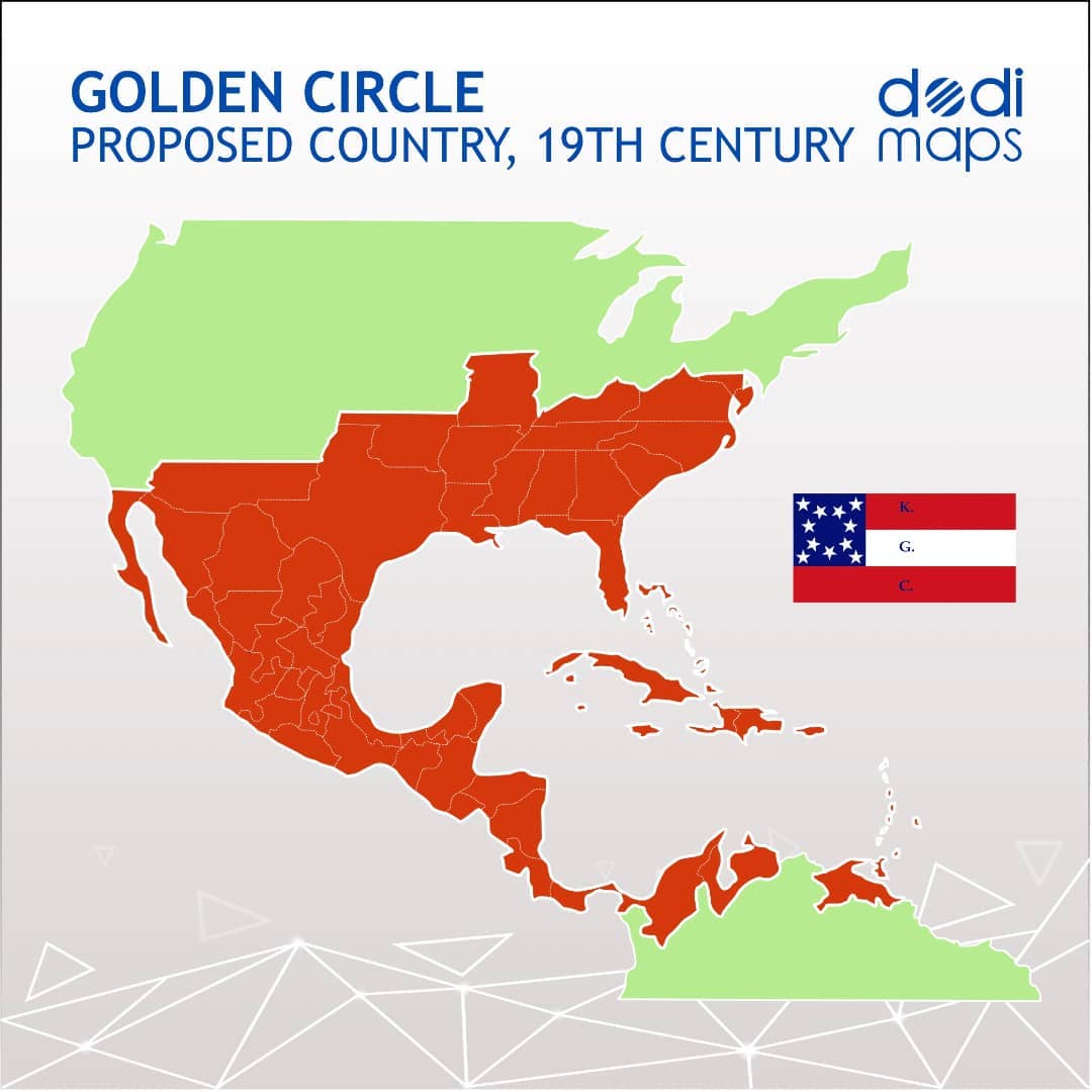
The Golden Circle was a proposed pro-slavery empire envisioned by a secretive 19th-century American organization called the Knights of the Golden Circle.
The plan centered on creating a vast slaveholding nation stretching around the Gulf of Mexico in a circle roughly 2,400 miles (3,900 km) in diameter. The proposed “Golden Circle” would have included:
Countries and Territories Intended for Inclusion
- The southern United States
- Mexico
- Cuba
- Haiti
- Dominican Republic
- Much of Central America, including areas of modern:
- Guatemala
- Honduras
- Nicaragua
- Costa Rica
- Panama
- Northern portions of South America, especially:
- Colombia
- Venezuela
Why?
The goal was to:
- Expand slavery into tropical regions suitable for plantation agriculture.
- Increase the political power of slaveholders.
- Create a powerful empire dominated by Southern interests.
- Counterbalance the growing population and influence of the Northern states.
What Happened?
Before the American Civil War, some Southern expansionists hoped the United States would annex parts of Latin America and the Caribbean.
After secession began, supporters shifted toward helping the Confederate States of America win independence and eventually expand southward.
The scheme never came close to succeeding. Mexico and the Caribbean nations remained independent, the Confederacy lost the Civil War, and the Golden Circle remained largely a fringe expansionist dream rather than an official government policy.
A useful way to think about it is that the Golden Circle was essentially an attempt to create a slaveholding superstate around the Gulf of Mexico, with the Confederacy at its core.
What if it existed today?
The population would be approximately 380–450 million people, depending on the exact borders.
For comparison:
- Current United States: ~340 million
- This Golden Circle state: roughly similar in population to the modern U.S. or slightly larger.
Likely Ethnic Composition
| Group | Approximate Share |
|---|---|
| Mestizo (mixed European/Indigenous) | 45–55% |
| White/European-descended | 15–25% |
| Black/Afro-descended | 15–20% |
| Indigenous | 8–15% |
| Other/Mixed | 2–5% |
Languages
| Language | Approximate Share |
|---|---|
| Spanish | 70–80% |
| English | 15–20% |
| French/Creole | 3–5% |
| Indigenous languages | 2–5% |
Religion
| Religion | Approximate Share |
|---|---|
| Christianity (mostly Catholic) | 70–80% |
| Protestant/Evangelical | 15–25% |
| Other/None | 5–10% |
Largest Metropolitan Areas
The biggest cities would likely include:
- Mexico City
- Bogotá
- Houston
- Monterrey
- Miami
- Caracas
- Guadalajara
- Atlanta
- Havana
- Santo Domingo
An Important Caveat
If the Golden Circle had actually been created in the 1860s, today’s demographics would probably be very different from simply adding together modern populations.
Migration patterns, economic development, slavery’s abolition, civil wars, industrialization, and immigration would all have unfolded differently.
Still, the most likely outcome is that it would be:
- A majority Spanish-speaking nation
- Roughly half Mestizo
- About 400 million people
- The largest country in the Western Hemisphere after modern-day Brazil or the U.S., depending on exact borders
- Culturally closer to a fusion of the American South, Mexico, the Caribbean, and northern South America than to either the modern U.S. or any single Latin American country.
What do you think of the plan?


Tim of Angle says
See S. M. Sterling’s DRAKA books.