Brilliant Maps

Making Sense Of The World, One Map At A Time

  • BOOK!
  • Newsletter
  • Board Games
  • Posters
  • Scratch Maps

The Largest Possible (Non-contiguous) Congressional District In Every Western State

Last Updated: April 27, 2026 Leave a Comment

Click To Get My 10 Best Brilliant Maps For Free:

The Largest Possible (Non-contiguous) Congressional District In Every Western State

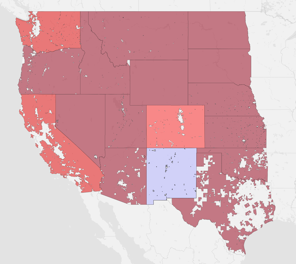
The map above was created by reddit user Tiny_Big_4998 who explains what it shows:

It’s always been hard for me to wrap my head around the true scale of population density in the American West.

I’m used to seeing maps on a county or state level, which really dilutes things through aggregation.

I see that a county has 20,000 people, and think “Wow, that’s really small.” Then, I find out that 17,000 of them live in 2 or 3 small towns, and think “holy shit, that’s unimaginably small.”

This map shows the largest possible (non-contiguous and absolutely illegal) congressional district in every western state.

Some, like California, were shockingly uncrowded (with 1/52nd of the population occupying ~85% of the space), while others like Montana or Idaho see half the population occupying well over 99.5% of the total area.

Oklahoma and Texas were surprising for the opposite reason— even the rural areas in the western half of the state were still pretty dense.

What do you think about the map?

Filed Under: United States

Click To Get My 10 Best Brilliant Maps For Free:


Other Popular Maps

  • How Many Electoral Votes Every State Would Gain/Lose If they were Proportional to Population

    How Many Electoral Votes Every State Would Gain/Lose If they were Proportional to Population

  • Who Wants To Join EU The Most?

    Who Wants To Join EU The Most?

  • Public Road Border Crossings Between the Republic of Ireland & Northern Ireland

    Public Road Border Crossings Between the Republic of Ireland & Northern Ireland

  • The World According To Apple Look Around (aka Apple Maps Street View)

    The World According To Apple Look Around (aka Apple Maps Street View)

  • Map of The Unexplored World From 1881

    Map of The Unexplored World From 1881

  • The 27 Best Map Based Strategy Board Games You’ve Probably Never Played

    The 27 Best Map Based Strategy Board Games You’ve Probably Never Played

  • All The Dedicated Cycle Paths In The Netherlands

    All The Dedicated Cycle Paths In The Netherlands

  • Map Of Viking Expansion Between 790 & 1066

    Map Of Viking Expansion Between 790 & 1066

Leave a Reply Cancel reply

Your email address will not be published. Required fields are marked *

This site uses Akismet to reduce spam. Learn how your comment data is processed.


Product Reviews · World Atlas · Settlers of Catan · Risk · Game of Thrones · Coloring Books
Globes · Monopoly · Star Wars · Game of Life · Pandemic · Ticket To Ride · Drinks Cabinets
US Locations · UK Locations· Fleet Management
Copyright © 2026 · Privacy Policy · Fair Use, Attribution & Copyright · Contact Us
Follow Us: Newsletter · Facebook · Youtube · Twitter · Threads · BlueSky · LinkedIn · Instagram · Pinterest · Flipboard