Brilliant Maps

Making Sense Of The World, One Map At A Time

  • BOOK!
  • Newsletter
  • Board Games
  • Posters
  • Scratch Maps

Cultural Regions Of Europe According The German Permanent Committee on Geographical Names

Last Updated: February 5, 2026 Leave a Comment

Click To Get My 10 Best Brilliant Maps For Free:

Cultural Regions Of Europe According To The Standing Committee On Geographical Names

Map created by reddit user Vhermithrax
The map above is a broad attempt to classify Europe’s main cultural and economic regions. Unlike other maps, it also highlights both national borders and cultural proximities.

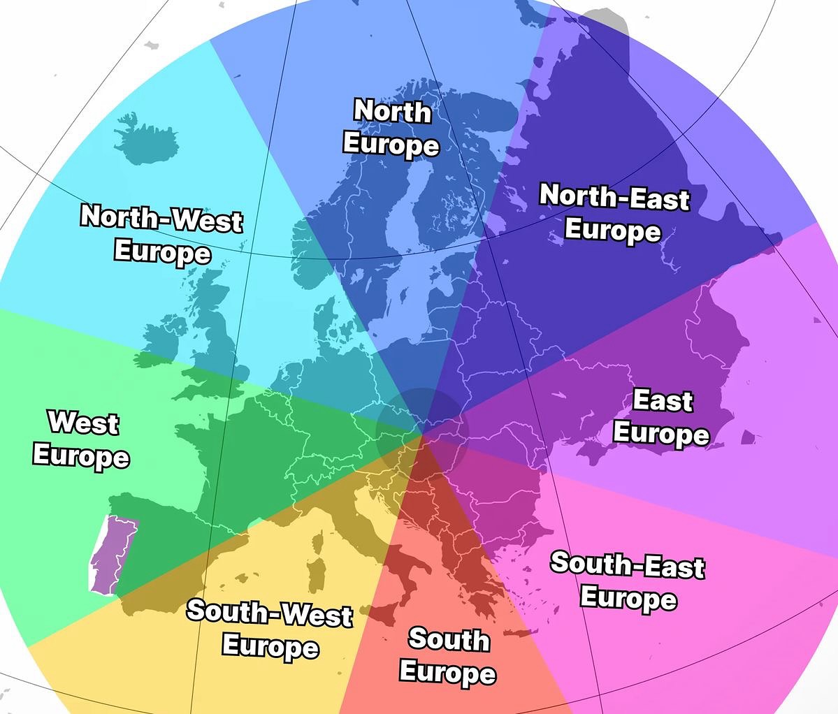
It’s based on the German Permanent Committee on Geographical Names (German: Ständiger Ausschuss für geographische Namen (StAGN)) definition of various regions.

They are:

  • Western Europe: Includes, UK, Ireland, Belgium, Netherlands and most of France.
  • Northern Europe: Norway, Sweden, Denmark, Iceland, and Finland
  • Central Europe: Germany, Austria, Switzerland, Poland, Czechia, Slovakia, Hungary, Slovenia, Croatia, and the Baltic countries and some of France, Italy, Romania and Ukraine.
  • Eastern Europe: Russia, Belarus, Ukraine
  • Southern Europe: Spain, Portugal, Italy, Malta and some of Southern France.
  • South Eastern Europe: Most of the Balkans, Greece, Bulgaria, Moldova, Cyprus, European Türkiye and most of Romania.

Here’s alternative version from Unimaps World:

European Compass

and another funny post from Dalmatian Mapper:

How people reacts when you say you're in Eastern Europe

What do you think? Do these feel accurate to you?

Filed Under: Europe

Click To Get My 10 Best Brilliant Maps For Free:


Other Popular Maps

  • The Barbary Slave Trade & Other European Slave Trade Networks Where People Were Abducted And Sold Into Slavery From As Far Afield As Iceland & Ireland

    The Barbary Slave Trade & Other European Slave Trade Networks Where People Were Abducted And Sold Into Slavery From As Far Afield As Iceland & Ireland

  • How Many Electoral Votes Every State Would Gain/Lose If they were Proportional to Population

    How Many Electoral Votes Every State Would Gain/Lose If they were Proportional to Population

  • Locations of Japanese Attacks On Australia During World War 2

    Locations of Japanese Attacks On Australia During World War 2

  • The Number of Comfortable Temperature Days Per Year: 10-29°C (50-85°F)

    The Number of Comfortable Temperature Days Per Year: 10-29°C (50-85°F)

  • Map Of The 18,000 Asteroids In The Solar System

    Map Of The 18,000 Asteroids In The Solar System

  • Map of Local Heartbrand Ice Cream Name By Country

    Map of Local Heartbrand Ice Cream Name By Country

  • Roman Empire GDP Per Capita Map Shows That Romans Were Poorer Than Any Country Today

    Roman Empire GDP Per Capita Map Shows That Romans Were Poorer Than Any Country Today

  • The World According To Ancient China

    The World According To Ancient China

Leave a Reply Cancel reply

Your email address will not be published. Required fields are marked *

This site uses Akismet to reduce spam. Learn how your comment data is processed.


Product Reviews · World Atlas · Settlers of Catan · Risk · Game of Thrones · Coloring Books
Globes · Monopoly · Star Wars · Game of Life · Pandemic · Ticket To Ride · Drinks Cabinets
US Locations · UK Locations· Fleet Management
Copyright © 2026 · Privacy Policy · Fair Use, Attribution & Copyright · Contact Us
Follow Us: Newsletter · Facebook · Youtube · Twitter · Threads · BlueSky · LinkedIn · Instagram · Pinterest · Flipboard