

As with our previous look at the Counterintuitive Comparison Of Relative Population Latitudes Of US, Canada & Europe, there are quite a few interesting things to note.
Just a few observations:
- London (51°30′N) is farther north than Calgary (51°03′N) with Amsterdam, Berlin and Dublin being located even further north.
- Montreal is south of Paris.
- Phoenix is placed close to the Ancient city of Carthage, which was a Phoenician city-state. People from Phoenix today are known as Phoenicians. (Credit: reddit users twomancanoe and svaachkuet)
- Miami is at the same latitude as Saudi Arabia.
- Honolulu at the same latitude as the Sahara desert.
- Los Angeles, San Diego, Phoenix and Houston are all at the same latitude as North Africa.
- Anchorage is further south than Reykjavik.
- Winnipeg has been placed near Lviv, Ukraine and coincidentally has a large Ukraine population. Even the city’s flag has Ukraine colours. (credit: reddit user ajyablo)
- Reykjavik’s average temperature in January is -0.6°C (31°F) and is warmer than Boston’s average January temperature of -1.7°C (29°F) despite Reykjavik being over 20 degrees further north (64°08′N vs 42°21′N).
- Missoula is placed roughly where Geneva is.
- The map also shows just how wide America and Canada are compared to Europe, stretching the equivalent distance from Spain to the Caspian Sea.
The reason many European cities have milder climates than equivalent cities in North America at the same latitude is of course the Gulf Stream.
And here are some more cities compared to Europe and Northern Africa based on their distance to the equator (from both the Northern and Southern hemispheres created by reddit user TipAlternative3734.
Europe:

Northern Europe:

Southern Europe & North Africa:

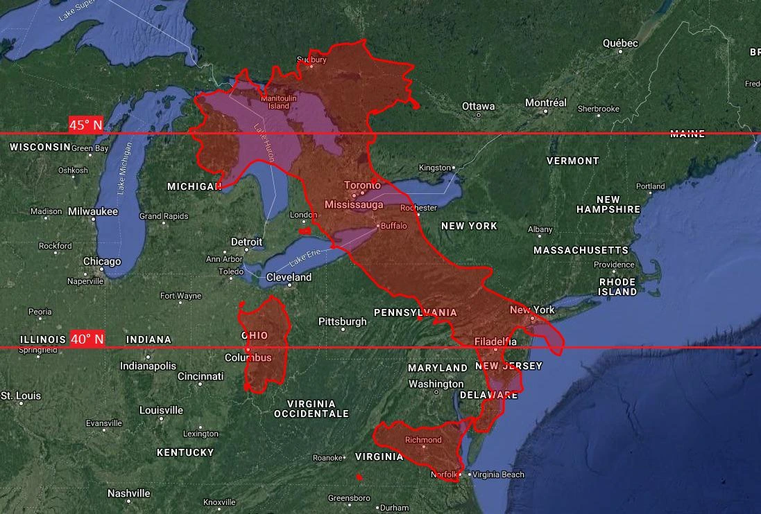
Also Italy over the US & Canada:
Curious what the map for the Southern hemisphere might look like? Well Reddit user Yearlaren has created the following map of South American cities transposed with Australian and New Zealand ones:
South American Cities On Australia & New Zealand

Australian & New Zealand Cities On South America

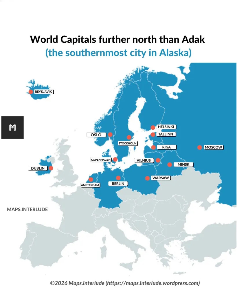
and finally World Capitals further north than Adak, Alaska (Alaska’s Southern most city).
Want to learn more about the Gulf Stream and relative latitudes? Then have a look at the following books:
- The Gulf Stream: Tiny Plankton, Giant Bluefin, and the Amazing Story of the Powerful River in the Atlantic
- Portrait of the Gulf Stream: In Praise of Currents
Notice anything else interesting about either map? Please leave your comments below.


Stephen T says
Almost all of Russia is in Canada.!? Brrrr!
Bonnie Mahlmeister says
I can’t read the map either. Could someone see that latitude with Madrid, Spain ?
RK says
The link is to some blog from 2011… the links to the supposed map on that blog, go to an error page.
kellson says
Why is the image resolution so low? Can’t make out the city names.
Willie says
I agree, the resolution is a bit dicey.
PeterT says
Microsoft’s ZoomIt will solve that. [Ctrl 1, Esc]
Or just Win-key +. [Win-key Esc]
J. Vaughan says
As an almost-totally-blind person, might I please ask what European cities are on the same latitude as Washington, D. C.?
Robert says
The closest are Ankara, Athens, Rome, Madrid, Valetta.
Gord Marsden says
The Gulf Stream plus the Mediterranean makes the difference in climate
Natalie Bomke says
The Great Lakes on you US map are wrong, honestly missing completely.
David says
Agree, the image quality is so poor that this website is unusable!
DDK says
Sadly, I can’t read a word of this map. I’ve been looking for something like this for a long time so it’s very disappointing that it’s unreadable. I even got out a big magnifying glass! ☹️
Murali S Vajapeyam says
This article does not explain why Chicago is so brutally cold in winter 🙂
Wayne Courtney says
Because the Great Lakes are fresh water lakes making them colder than the salt water oceans, making the winds that come off of them very cold. In Contrast European countries are warmer because of the Gulf Stream and the salt water of the Mediterranean Sea.
William Kreml says
CHICAGO WINTERS ARE MORE MODERATE THAN THEY USED TO BE.
OK says
Use your “mouse” and “click” on it to “enlarge” it.
DebraK says
Thanks! That works great.
Marton Kiss says
Very kool maps. But….as a person from Edmonton, Alberta, Canada, the Capital of this province, we HATE seeing Calgary as a representation of our corner of the world. Again….Edmonton is the Capital! Pleeze, fellow readers, pay NO attention to Calgary! It is the Marsha Brady of our province….Marsha, Marsha, Marsha.
smf says
deadmenton vs calgreedy
Brian says
Parts of California, USA are on the same latitude
Joan says
To what?
Karthikeyan says
For those who could not read the map, please click on the map image to find a bigger image.
https://i.imgur.com/yIe8gWy.jpg
Starfire says
Where’s Toronto?? Canada’s largest city!
Kosta says
This map is completely useless with such terrible resolution.
Rick O'Shay says
Greetings from Texas. Thanks for the info.
I always thought Edmond was some guy who lived in Calgary.
Jack Jones says
It’s “Kyiv” not “Kiev”.
Gavin says
All of eastern Canada is missing along with the bottom of Mexico, and yet you bothered to include Alaska. If you are going to claim something is North America, then mean it. Otherwise just describe it as your BS USA perspective.
phil allen says
Would’ve been apt to place San Francisco near Athens. A better match awaits, although I’d hoped New York would be closer to Rome’s lat (get it?) ..