
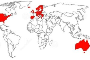
This map is from the 5 February 1940 edition of Facts in Review, a Nazi magazine published in the United States by the German Library of Information.
Underneath it was the following caption:
Germany’s eighty-seven million inhabitants are subsisting on 264,300 square miles including former Austria, Bohemia-Moravia, Danzig, and the re-incorporated Province of Poland, (excluding the Gouvernement General).
Great Britain, a nation of approximately forty-six million people, has in the course of her history acquired an Empire as shown above. It covers an area of 13,320,854 square miles including the former German colonies.
Source: Monmonier, M. 2018. How to Lie with Maps. 3rd edn.
The first thing to note about the above is that the German claim is that it only looks at the White population of the British Empire.
By 1925 the British Empire had around 450 million people living in it, over 85% of which were non-White.
As for including former German colonies, that was one of the conditions for the Treaty of Versailles, which Germany signed after losing World War 1.
To me the rather obvious message coming from the study in Empires above is that the Germans wanted to emulate the British rather than criticise them.
For more see: What If Nazi Germany Won World War II? Fictional & Historical Scenarios
What do you think about the map?

![Where is the north/south divide? [Map Men]](https://brilliantmaps.com/wp-content/uploads/hqdefault-19-300x200.jpg)


Leave a Reply