Brilliant Maps

Making Sense Of The World, One Map At A Time

  • BOOK!
  • Newsletter
  • Board Games
  • Posters
  • Scratch Maps

Europe & The Mediterranean From A Different Perspective

Last Updated: August 28, 2024 1 Comment

Click To Get My 10 Best Brilliant Maps For Free:

Europe & The Mediterranean From A Different Perspective

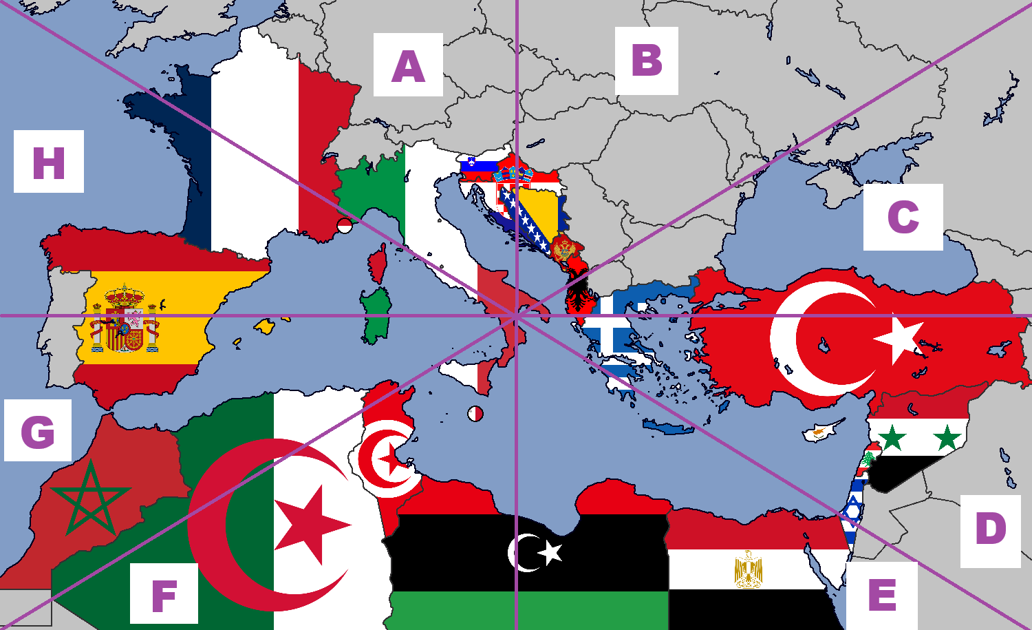
This map is a detailed representation of the Mediterranean region, showcasing a large portion of Southern Europe, Northern Africa, and parts of the Middle East, but from a rather different perspective.

Instead of the map being oriented with North at the top, you have West at the top.

It was crated by Sabine Réthoré in 2011 and it’s French title was Méditerranée Sans Frontières 2011. This translates to “Mediterranean Without Borders 2011,” suggesting that the map was created with a theme emphasizing the interconnectedness of the Mediterranean region, transcending national boundaries.

The map highlights major cities, geographic features, and bodies of water, with a focus on the Mediterranean Sea (“Méditerranée”) and the surrounding regions.

Key Features of the Map:

  1. Geographic Scope: It includes parts of Spain, France, Italy, Greece, Turkey, and several other European countries. It also covers North African countries such as Morocco, Algeria, Tunisia, Libya, and Egypt, extending eastwards to parts of the Middle East, including Lebanon, Israel, and parts of Turkey.
  2. Major Bodies of Water:
    • Mediterranean Sea (“Méditerranée”)
    • Ionian Sea (“Mer Ionienne”)
    • Adriatic Sea
    • Aegean Sea
    • Black Sea (“Mer Noire”)
    • Various gulfs and bays are also marked, providing a detailed view of the Mediterranean basin.
  3. Cities and Capitals: The map names many cities, including capitals and significant regional hubs, making it useful for understanding the distribution of urban centers around the Mediterranean.
  4. Topography: The map uses shaded relief to indicate mountains, plains, and coastal areas, giving a clear idea of the region’s physical landscape.

Filed Under: Europe

Click To Get My 10 Best Brilliant Maps For Free:


Other Popular Maps

  • Beaver Populations By Type in Europe: 1900 vs. 2021

    Beaver Populations By Type in Europe: 1900 vs. 2021

  • Estimated European Black Population By Country In 2020

    Estimated European Black Population By Country In 2020

  • The World’s 5 Biggest Economies

    The World’s 5 Biggest Economies

  • Timelapse Map of Every Battle in History

    Timelapse Map of Every Battle in History

  • Flag Map of The World In 1988

    Flag Map of The World In 1988

  • Israel’s Territory Before & After The Six-Day War In 1967

    Israel’s Territory Before & After The Six-Day War In 1967

  • The 11 Emerging Mega-Regions Of The United States

    The 11 Emerging Mega-Regions Of The United States

  • Tehran Metro vs Los Angeles Metro Rail

    Tehran Metro vs Los Angeles Metro Rail

Comments

  1. Y.D. Robinson says

    August 29, 2024 at 11:34 am

    This kind of reminds me of upside-down world maps produced in such Southern Hemisphere countries as Australia and Argentina.

    Reply

Leave a Reply Cancel reply

Your email address will not be published. Required fields are marked *

This site uses Akismet to reduce spam. Learn how your comment data is processed.


Product Reviews · World Atlas · Settlers of Catan · Risk · Game of Thrones · Coloring Books
Globes · Monopoly · Star Wars · Game of Life · Pandemic · Ticket To Ride · Drinks Cabinets
US Locations · UK Locations· Fleet Management
Copyright © 2026 · Privacy Policy · Fair Use, Attribution & Copyright · Contact Us
Follow Us: Newsletter · Facebook · Youtube · Twitter · Threads · BlueSky · LinkedIn · Instagram · Pinterest · Flipboard