Brilliant Maps

Making Sense Of The World, One Map At A Time

  • BOOK!
  • Newsletter
  • Board Games
  • Posters
  • Scratch Maps

Size Comparison of Roman & Ottoman Empires At Their Peak

Last Updated: May 18, 2026 Leave a Comment

Click To Get My 10 Best Brilliant Maps For Free:

Size Comparison of Roman & Ottoman Empires At Their Peak

Map found on reddit
This map is a comparative visualization showing the territories controlled by both the Roman Empire and the Ottoman Empire at different points in history.

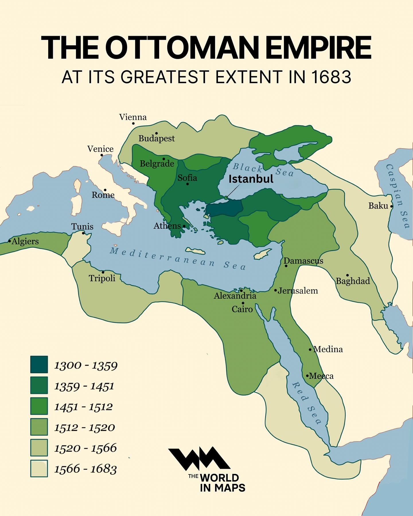
The map uses three colors to represent areas:

  1. Blue: Areas only controlled by the Roman Empire.
  2. Red (overlapping areas): Regions controlled by both empires at different times.
  3. Dark Brown  Areas only controlled by the Ottoman Empire.

By the Numbers:

  • Roman Empire: Maximum size 5.0 million sq km (1.93 sq miles), 3.71% of the world in 117 AD.
  • Ottoman Empire:  Maximum size 5.2 million sq km (2.01 sq miles), 3.86% of the world in 1683.

Context and Significance:

The Roman Empire (27 BC – 476 AD in the West; up to 1453 AD in the East)

  • The Roman Empire, one of the most influential empires in history, reached its peak around the 2nd century AD. It controlled vast territories across Europe, North Africa, and the Middle East.
  • The Roman Empire was divided into the Western Roman Empire and the Eastern Roman Empire (Byzantine Empire) in the 4th century AD.
  • The Western Roman Empire fell in 476 AD, while the Byzantine Empire continued until 1453 AD, when it was conquered by the Ottoman Turks.

The Ottoman Empire (1299 – 1922)

The Ottoman Empire At Its Maximum Extent

Map created by World In Maps

  • The Ottoman Empire, founded in 1299, became one of the longest-lasting empires in history. It expanded across the Middle East, North Africa, and Southeast Europe.
  • The empire reached its peak during the 16th and 17th centuries under leaders like Suleiman the Magnificent, covering parts of Europe, including the Balkans, the Middle East, and North Africa.
  • The empire fell after World War I and was officially dissolved in 1922, giving rise to the modern nation of Turkey.

Analysis of the Map:

  • The Blue regions indicate that the Roman Empire extended far into Western Europe, including areas like present-day Spain, France, and the UK, territories never controlled by the Ottoman Empire.
  • The Brown areas show the extent of the Ottoman Empire’s control, which covered regions like the Arabian Peninsula, Mesopotamia, and the Horn of Africa—areas not reached by the Romans.
  • The Red areas highlight significant regions of overlap, such as parts of the Balkans, North Africa, and the Eastern Mediterranean, which were controlled by both empires at different times.

For something similar have a look at our maps:

  • The Roman Empire vs. The Mongol Empire
  • Roman Empire vs United States
  • British vs Mongol Empires
  • Map Of The Roads Of The Roman Empire in 200AD

Filed Under: History

Click To Get My 10 Best Brilliant Maps For Free:


Other Popular Maps

  • California, Sweden and Madagascar Are Surprisingly Similar in Size

    California, Sweden and Madagascar Are Surprisingly Similar in Size

  • Adam’s Bridge Between India and Sri Lanka Before 1480

    Adam’s Bridge Between India and Sri Lanka Before 1480

  • Watch The 21 Year Great Northern War On Google Maps

    Watch The 21 Year Great Northern War On Google Maps

  • Map Of The Best & Worst Pizza Chains In Each US State

    Map Of The Best & Worst Pizza Chains In Each US State

  • Map Showing How Cereals Took Over The World

    Map Showing How Cereals Took Over The World

  • A Lighthouse Map of Great Britain & Ireland

    A Lighthouse Map of Great Britain & Ireland

  • 10,000 Garmin SOS Calls Showing The Most Dangerous Places For Outdoor Activities On Earth

    10,000 Garmin SOS Calls Showing The Most Dangerous Places For Outdoor Activities On Earth

  • Travel Times From London in 2016 vs 1914

    Travel Times From London in 2016 vs 1914

Leave a Reply Cancel reply

Your email address will not be published. Required fields are marked *

This site uses Akismet to reduce spam. Learn how your comment data is processed.


Product Reviews · World Atlas · Settlers of Catan · Risk · Game of Thrones · Coloring Books
Globes · Monopoly · Star Wars · Game of Life · Pandemic · Ticket To Ride · Drinks Cabinets
US Locations · UK Locations· Fleet Management
Copyright © 2026 · Privacy Policy · Fair Use, Attribution & Copyright · Contact Us
Follow Us: Newsletter · Facebook · Youtube · Twitter · Threads · BlueSky · LinkedIn · Instagram · Pinterest · Flipboard