
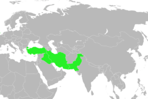
Here are a few key regions and states featured in the map:
1. The Song Dynasty (China)
- The Song Dynasty was one of the most advanced and prosperous civilizations of its time. The Song controlled much of eastern China, with a strong economy based on trade, agriculture, and a thriving intellectual culture. Despite its technological and cultural achievements, the Song faced threats from northern neighbors like the Jurchen Jin Dynasty.
2. The Mongols
- While not yet the dominant force they would become later under Genghis Khan, the Mongol tribes were beginning to unite. Located in central Asia, the Mongols were on the verge of their rapid expansion, which would soon lead to one of the largest empires in history.
3. The Ayyubid Sultanate (Middle East)
- The Ayyubid Sultanate, established by Salah al-Din (Saladin), controlled Egypt, parts of the Levant, and Arabia. It was a significant Islamic state and played a crucial role in the Crusades. At its height, the Ayyubids held much of the Islamic world’s political and military power.
4. The Holy Roman Empire (Europe)
- The Holy Roman Empire spanned much of central Europe and was a complex entity with numerous semi-autonomous territories. In 1200, the empire was a significant force in European politics and was involved in both religious and secular matters. However, its decentralized nature made governance challenging.
5. The Ghurid Sultanate (India)
- The Ghurids were a Persianate dynasty ruling over parts of modern Afghanistan, Iran, and northern India. They played a key role in spreading Islam into the Indian subcontinent and were precursors to the later Delhi Sultanate.
6. Khwarezm Empire (Central Asia)
- Located in what is now Iran, Turkmenistan, Uzbekistan, and Kazakhstan, the Khwarezm Empire was a powerful state controlling major trade routes, including parts of the Silk Road. They would soon be one of the first major targets of Genghis Khan’s Mongol conquests.
7. The Khmer Empire (Southeast Asia)
- The Khmer Empire, based in present-day Cambodia, was a dominant regional power known for its impressive architecture, including the famous Angkor Wat temple complex. The Khmer were at their peak during this period, controlling vast territories across Southeast Asia.
These states represent a mix of political, economic, and military power centers in the Eastern Hemisphere just before the transformative rise of the Mongol Empire. The period was marked by flourishing trade, cultural exchange, and regional conflicts, setting the stage for major shifts in global dynamics over the following century.


Angela says
Hi,
All i can say is Wow! I like maps. The map from 250 million years ago was totally awesome in today continents and borders. Places like Korea seemed almost upside down. Japan wasn’t a island. Alaska? Forget about it… it was split in two, now how cool is that?, especially since it the largest state in the union. I would definitely like to get a map. I can show my grandchildren.
Thank you for your hard work in letting us see, learn, understand and wonder about our beautiful blue marble we call home, Earth.