Brilliant Maps

Making Sense Of The World, One Map At A Time

  • BOOK!
  • Newsletter
  • Games & Quizes
  • Map Based Polls
  • Map Tools

Dr. Seuss WW2 Malaria Education Map

Last Updated: November 3, 2026 Leave a Comment

Click To Get My 10 Best Brilliant Maps For Free:

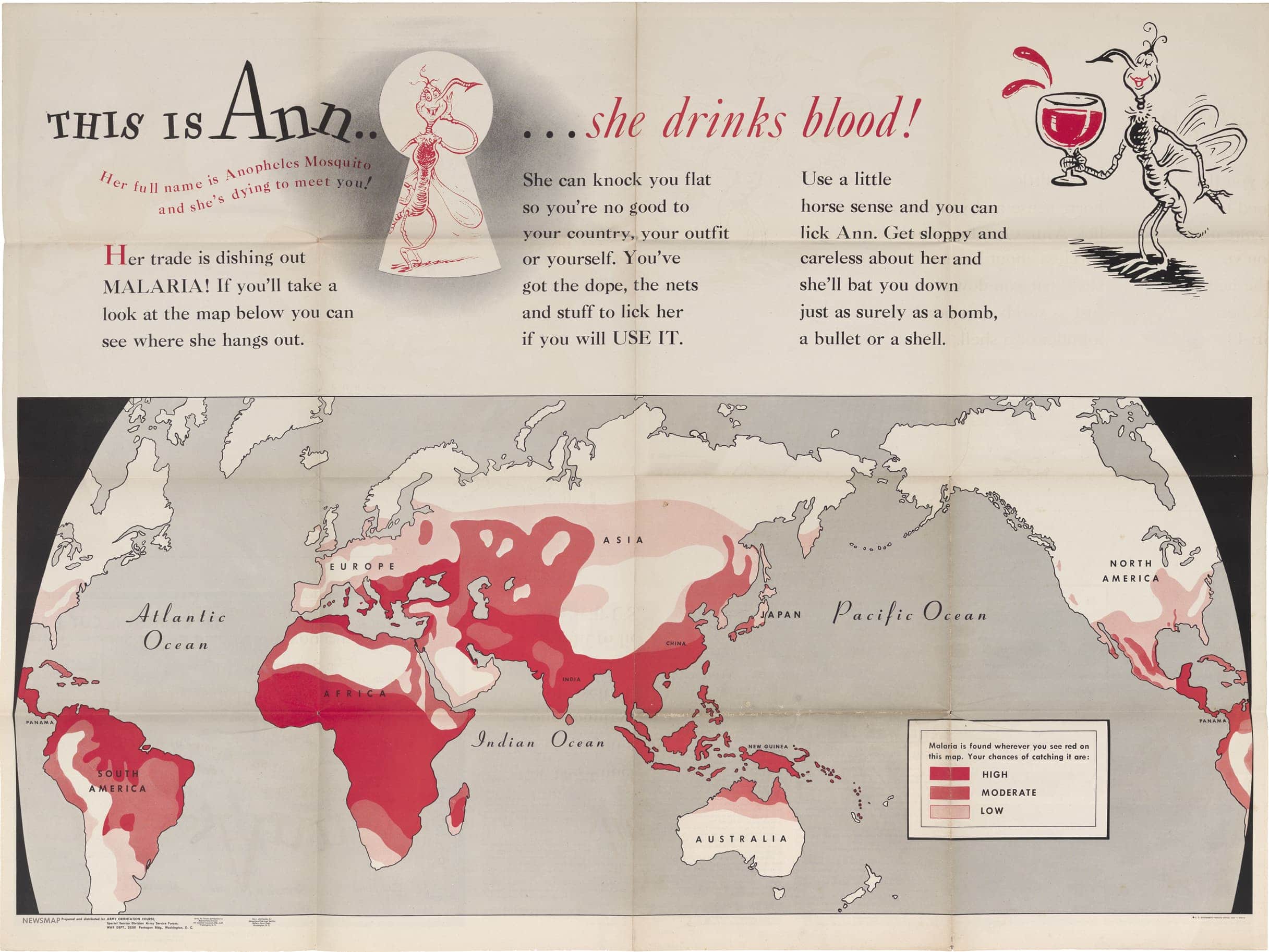
Dr. Seuss WW2 Malaria Education Map

Prepared and distributed by Army Orientation Course – Special Service Division – Army Service Force – War Dept. Monday, November 8, 1943. Map found here

The map above was created in 1943 by a young Army Captain named Theodore Geisel (aka Dr. Seuss) to educate American servicemen about the dangers of malaria. Titled This is Ann . . . She drinks blood! you can see his very unique illustrations for the mosquitos.

Text from the image:

“THIS IS Ann… she drinks blood!

Her full name is Anopheles Mosquito and she’s dying to meet you!

Her trade is dishing out MALARIA! If you’ll take a look at the map below you can see where she hangs out.

She can knock you flat so you’re no good to your country, your outfit or yourself. You’ve got the dope, the nets and stuff to lick her if you will USE IT.

Use a little horse sense and you can lick Ann. Get sloppy and careless about her and she’ll bat you down just as surely as a bomb, a bullet or a shell.”

A summary of the map from Boston Rare Maps.

This rare 1943 American military poster was created to educate soldiers about the dangers of malaria during World War II.

Following Japan’s conquest of major quinine-producing regions in Southeast Asia, malaria became a serious threat to Allied troops, sometimes causing more casualties than combat itself.

The poster, titled “This Is Ann… She Drinks Blood!”, uses humour and illustrations attributed to Theodore Geisel (Dr. Seuss) to encourage soldiers to protect themselves against mosquitoes.

It also features a world map highlighting areas at greatest risk of malaria, including southern Italy and the South Pacific, where American forces were fighting.

The poster formed part of a wider military campaign to prevent malaria through education and public health measures.

You can read more about it here and here.

Filed Under: World Maps

Click To Get My 10 Best Brilliant Maps For Free:


Other Popular Maps

  • Europe’s Declining Robbery Rates

    Europe’s Declining Robbery Rates

  • Map of The 210 TV Media Markets In The US (Including Territories)

    Map of The 210 TV Media Markets In The US (Including Territories)

  • Armenians in the Borders of Modern Turkey

    Armenians in the Borders of Modern Turkey

  • Most Recurring Word On Each Country’s Wikipedia Page

    Most Recurring Word On Each Country’s Wikipedia Page

  • Average Colour Hue of Country & US State Flags

    Average Colour Hue of Country & US State Flags

  • Map Showing The Photosynthesis of the US Corn Crop

    Map Showing The Photosynthesis of the US Corn Crop

  • 18 Brilliant Untranslatable Words From European Languages

    18 Brilliant Untranslatable Words From European Languages

  • Porn Stars Per Million People In Europe

    Porn Stars Per Million People In Europe

Leave a Reply Cancel reply

Your email address will not be published. Required fields are marked *

This site uses Akismet to reduce spam. Learn how your comment data is processed.


Product Reviews · World Atlas · Map Posters · Settlers of Catan · Risk · Game of Thrones · Coloring Books · Globes · Monopoly · Star Wars · Game of Life · Pandemic · Ticket To Ride · Drinks Cabinets
Size Comparisons · US Locations · Flight Maps · Fleet Management
Copyright © 2026 · Privacy Policy · Fair Use, Attribution & Copyright · Contact Us
Follow Us: Newsletter · Facebook · Youtube · Twitter · Threads · BlueSky · LinkedIn · Instagram · Pinterest · Flipboard