Brilliant Maps

Making Sense Of The World, One Map At A Time

  • BOOK!
  • Newsletter
  • Games & Quizes
  • Map Based Polls
  • Map Tools

The Pacific Ocean is Larger Than All Land On Earth

Last Updated: September 17, 2025 4 Comments

Click To Get My 10 Best Brilliant Maps For Free:

All land on earth compared to pacific ocean

Map by Chris Stephens, from naturalearthdata.com
While I’m sure you know the Pacific Ocean is big, I’d say there’s a good chance you hadn’t realized how big, until you look at the map above. As difficult as it may be to believe, the Pacific Ocean is larger than the landmass of every single continent and island combined.

In numbers:

The Pacific Ocean covers: 165.25 million square kilometers

The Earth’s Land Mass covers: 148.94 million square kilometers

And in case you were wondering, Chris has used the Fuller (or Dymaxion) projection to preserve the relative size and shape of continents.

Here’s another version of the map created by The World In Maps using True Size of countries:
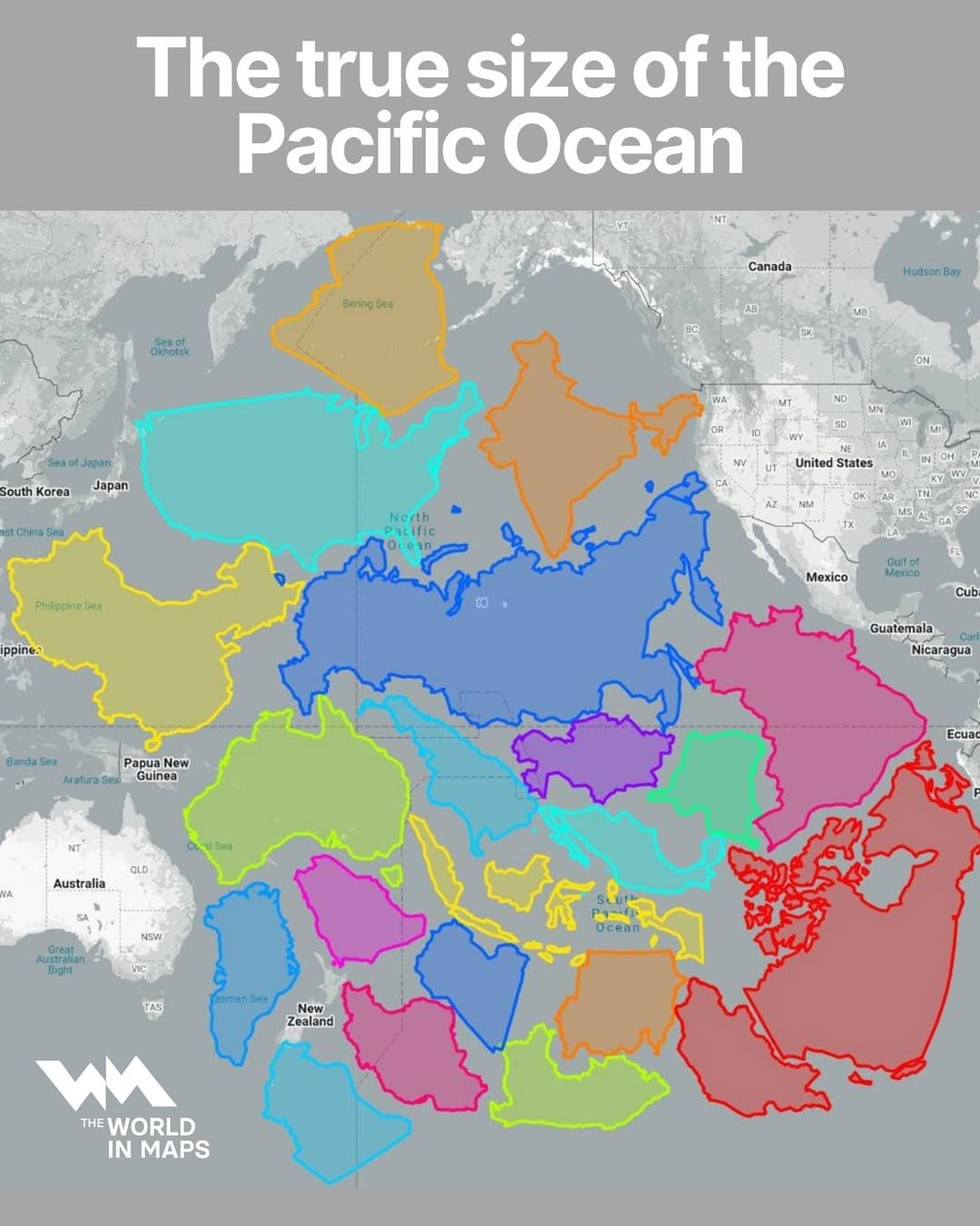
True Size of the Pacific Ocean

Want to learn more? Then read:

  • The Great Ocean: Pacific Worlds from Captain Cook to the Gold Rush
  • Magnificent Creatures of the Pacific Ocean
  • Pacific Ocean (Oceans of the World)

What do you think of this map. Leave a comment below:
Filed Under: World Maps Tagged With: comparison, oceans

Click To Get My 10 Best Brilliant Maps For Free:


Other Popular Maps

  • Is This The Worst World Map Ever?

    Is This The Worst World Map Ever?

  • Non-Inflation Adjusted House Prices In 2000 vs 2026 in The United States

    Non-Inflation Adjusted House Prices In 2000 vs 2026 in The United States

  • Wettest & Driest Months of the Year

    Wettest & Driest Months of the Year

  • Zone Rouge: An Area of France So Badly Damaged By WW1 That People Are Still Forbidden To Live There

    Zone Rouge: An Area of France So Badly Damaged By WW1 That People Are Still Forbidden To Live There

  • 1587 Flat Earth Map of the World By Urbano Monte

    1587 Flat Earth Map of the World By Urbano Monte

  • Pedestrian Crossing Signs of Europe

    Pedestrian Crossing Signs of Europe

  • Countries With a Higher Or Lower GDP Per Capita Vs Washington DC

    Countries With a Higher Or Lower GDP Per Capita Vs Washington DC

  • The Technate of America: A Plan To Replace Partisan Politicians & Business People With Scientists & Engineers

    The Technate of America: A Plan To Replace Partisan Politicians & Business People With Scientists & Engineers

Comments

  1. Mysterio1000 says

    March 2, 2017 at 1:23 am

    This is certainly very interesting.

    Reply
    • Y.D. Robinson says

      October 6, 2025 at 9:01 pm

      And it’s wild to think about it!

      Reply
  2. andrew says

    September 7, 2022 at 3:01 pm

    This map is certainly a great way to make the important point of just how huge the Pacific really is. Presently, I’m putting together a children’s book about Pacific voyaging and would be interested in making contact with Chris to see if we can use a version of this in the book. Can you help? Thanks.

    Reply
  3. Christopher says

    February 15, 2023 at 11:39 pm

    Western Russia?

    Reply

Leave a Reply Cancel reply

Your email address will not be published. Required fields are marked *

This site uses Akismet to reduce spam. Learn how your comment data is processed.


Product Reviews · World Atlas · Map Posters · Settlers of Catan · Risk · Game of Thrones · Coloring Books · Globes · Monopoly · Star Wars · Game of Life · Pandemic · Ticket To Ride · Drinks Cabinets
Size Comparisons · US Locations · Flight Maps · Fleet Management
Copyright © 2026 · Privacy Policy · Fair Use, Attribution & Copyright · Contact Us
Follow Us: Newsletter · Facebook · Youtube · Twitter · Threads · BlueSky · LinkedIn · Instagram · Pinterest · Flipboard