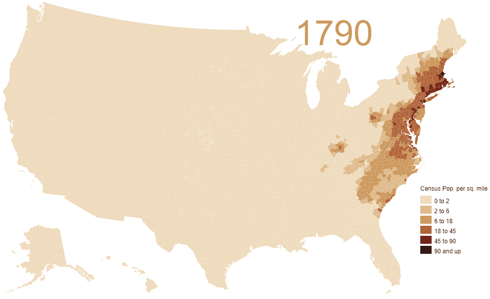
In 1790, population density was just 4.5 people per sq. mile. But by 2010 it had grown to 87.4 people per sq. mile over a much larger area.
From the original map author:
This is a map of population density, made using Jonathan Schroeder’s county-level decadal estimates.
I’ve interpolated populations for intermediate years by interpolating cubic splines to log-density; essentially, that means that it assumes a smooth change in the rate of growth for each county over time.
This is nice because the continuous filling makes it easier, for me at least, to see the process of settlement as continuous.
On the other hand: this produces wrong information!
For instance, many Oklahoma counties became heavily populated in 1891 or 1893 as soon as the federal government; but the algorithm doesn’t fill them in until later.
Speaking of Oklahoma, this is census population, which does not include most native nations.
You can watch the video below to stop and pause on a particular year:
According to the 2020 US census there are 331.4 million people living in the United States.
It should be noted that the map above has its shortcomings most notably the fact it doesn’t count Native Americans until they became full US citizens.
And there remains a huge variation in US population density.
New Jersey is the densest state with 1,207 people per sq mile, while Alaska has only 1.28 or 1/1000th the population density. Washington DC is even denser at 11,685 people per sq. mile but is not yet a state.
A short History of US Population Density
The United States’ population density has evolved dramatically from its early days as a collection of sparse, agrarian communities to a nation marked by dense urban centers and sprawling suburban regions.
Here’s a brief overview of that transformation:
1790–Mid‑19th Century: Foundations and Frontier Expansion
- 1790: When the first U.S. census was taken, the nation had roughly 3.9 million inhabitants. The population was concentrated in the 13 original states, and the average density was very low—only a few people per square mile—because the nation’s territory was vast compared to its population.
- Early 1800s: As the country expanded westward (through events like the Louisiana Purchase in 1803), new territories were added. These lands were largely unsettled, so even though the overall population was growing, much of the nation’s land remained sparsely populated.
- Mid‑19th Century: Westward migration and the early stirrings of the Industrial Revolution began to change the landscape. While rural areas and frontier lands still had low densities, growing towns and cities—especially in the Northeast—started to show pockets of higher population density.
Late‑19th Century: Industrialization and Urban Concentration
- Industrial Boom: The latter half of the 1800s saw rapid industrialization. Cities like New York, Chicago, and Philadelphia became hubs for manufacturing and commerce, drawing millions of immigrants and rural migrants.
- Urban Density: This influx led to a dramatic rise in the population density of urban centers. While the national average remained moderate because vast rural and frontier areas still had few inhabitants, cities became much more crowded and laid the groundwork for modern urban density patterns.
Early‑to‑Mid‑20th Century: Continued Growth and Suburbanization
- Early 1900s: Immigration and continued internal migration fueled further growth. Urban centers expanded vertically and horizontally, with dense neighborhoods emerging alongside more modest, less densely populated areas.
- Post‑World War II: Economic prosperity and the development of the interstate highway system spurred a major shift. Many Americans moved to newly built suburbs, leading to a diffusion of population. Although some city centers experienced a decline in density due to suburban flight, the overall population of the country surged—by 1950, the U.S. population had roughly doubled compared to 1900.
Late‑20th Century to 2020: A Nation of Contrasts
- Modern Era: By the turn of the 21st century, the U.S. population had swelled to over 280 million people. Nationwide, the average density increased—by 2020, it was roughly 90–100 persons per square mile. However, this figure averages together the extremely high densities of metropolitan areas with the very low densities found in rural regions.
- Regional Disparities: Today, places like New Jersey or the urban cores of New York and San Francisco boast densities that can reach thousands of people per square mile, while vast portions of the Great Plains, the Rocky Mountains, and rural parts of the South remain sparsely populated. The modern American landscape is thus a patchwork: dense urban hubs, extensive suburbs, and large, open rural areas.
And finally here’s another version showing the largest state by decade:
Enjoy this map? Please help by sharing it and leave your comments below:


Brian C Clark says
Wait, no one lived in North American before the whites arrived? really? how offensive can you get?
Vandy Beth Glenn says
I would guess before whites arrived, population density was less than 1 person per square mile.
Chris F says
Yes, I was thinking of that. Plus, the boundaries of the US changed. The profile should show the borders in that year, or better still the area which actually had a census.
People lived in Texas, Florida and California before the US annexed them. And I guess it took some time after most areas were incorporated and settled before the census counters arrived (e.g. North West).
Fuck you Brian says
The census only records US citizens dummy.
ChrisM says
Sorry to say the census records all residents. Citizens, legal residents, and illegal residents. Most illegals aren’t counted though because of their fear of getting caught and sent back to home country. The census bureau however does not interact with INS/ICE which most illegals don’t know.
Enid Ruth Pollock says
Pretty cool way to look at it . Oklahoma is interesting – a late starter
Thanks
allen stewart says
Big fail. This is about Anglo people only.
Nono says
Triggered troon detected
Hero Young Trusler says
No it’s not. Lots of immigrants came from non-Western countries and have been included in the census. I know what you are getting at but for one, the native populations decreased, not increased, and would have been largely on reservations which would have their own censuses that were separate. And anyway, this is a map to give a sense of population growth, not a map for discussing the ins and outs of injustice. Stop micro-managing.
Eduardo says
It’s depressing to notice that you were completely aware of the “shortcoming” but still chose to use “US Population” in the post title and text as if Native American population didn’t matter at all.
Jack says
Literally, even after 2 centuries of population decline between the 1500s and 1700s, there were still over 100k Cherokee people living in North Georgia, Southern Tenn in 1800. Where are they on this map?
Kevin says
This map is a perfect example of the myth that settlers arrived and built the United States on literally empty lands. This myth justifies settler colonialism, eraseing the real indigenous genocide the US was built on. A one sentence disclaimer on the map’s shortcomings isn’t enough, you should really just not share this.
Laird of the Glebe says
Thanks for this. The one piece of explanation that would be good (necessary?) to include would be the various methodologies for who was counted. This is certainly a great representation of *something* but we’re not told exactly what. Thanks for this post – it’s visually stunning.