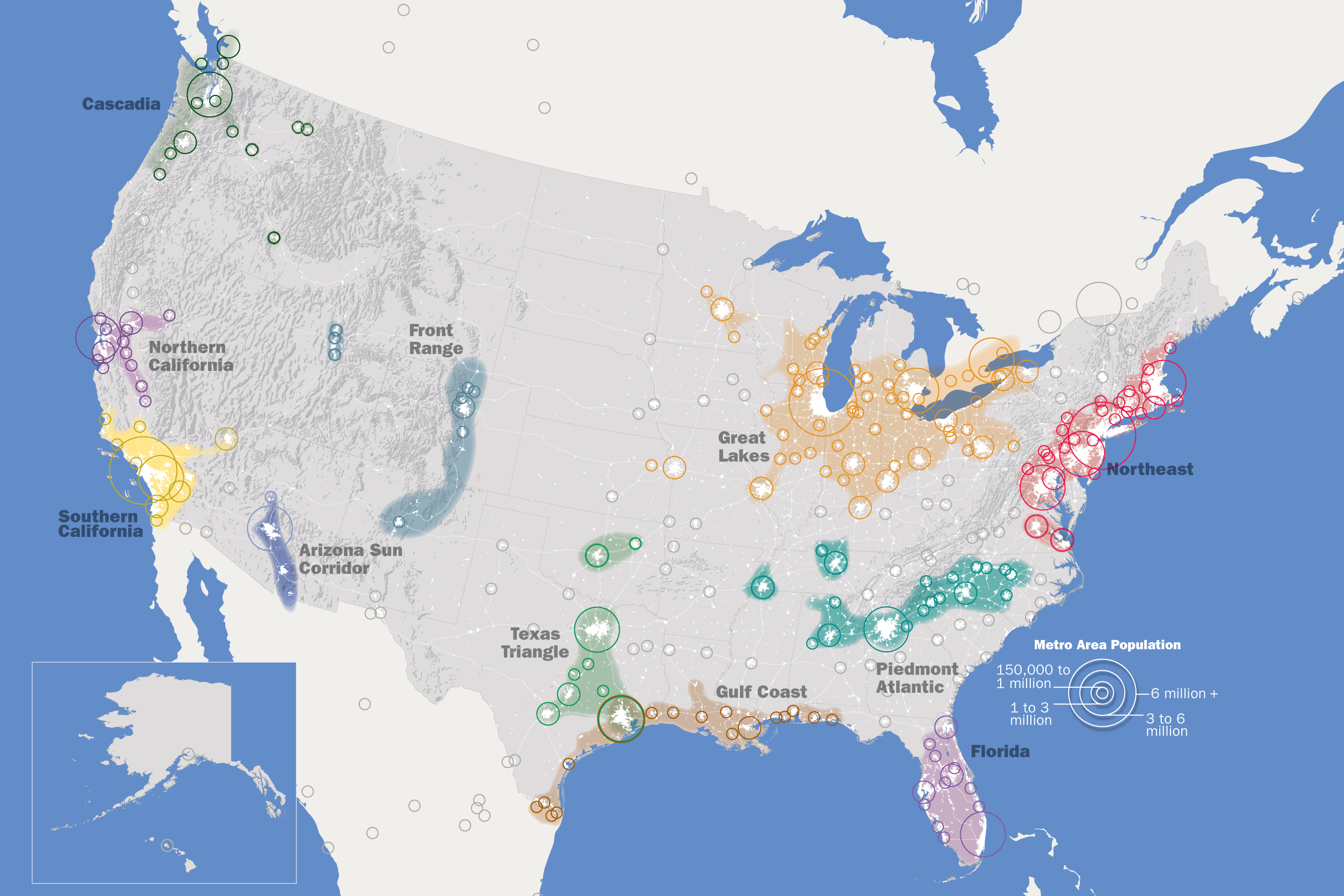
The map above shows the Regional Plan Association’s list of 11 Mega-Regions of the United States as part of their America 2050 project.
In terms of the estimated population in 2025 they would rank in the following order: (population in 2010)
- Great Lakes: 60.7 million (55.5 million) – includes Chicago, Toronto, and Detroit
- Northeast: 58.4 million (52.3 million) – includes New York, Boston, Philadelphia and Washington
- Southern California: 29 million (24.4 million) – includes Los Angeles, San Diego and Las Vegas
- Texas Triangle: 24.8 million (19.7 million) – includes Houston, Dallas, San Antonio and Austin
- Piedmont Atlantic: 21.7 million (17.6 million) – includes Atlanta
- Florida: 21.5 million (17.3 million) – includes Miami, Orlando, and Tampa Bay
- Northern California: 16.4 million (14 million) – includes San Francisco, San Jose and Oakland
- Gulf Coast: 16.3 million (13.4 million) – includes Houston and New Orleans
- Cascadia: 13.5 million (12.4 million) – includes Vancouver. Seattle and Portland
- Arizona Sun Corridor: 7.8 million (5.6 million) – includes Phoenix
- Front Range: 6.9 million (5.5 million) – includes Denver
Notes:
- The populations given for megalopoleis that extend into Canada and Mexico (Cascadia, Great Lakes, and Southern California) include their non-U.S. residents.
- Houston appears twice (as part of Gulf Coast and Texas Triangle).
You can read the Wikipedia article to learn more about where the whole idea for these comes from.
For more on Mega Regions have a look at the following books:
- Megaregions: Planning for Global Competitiveness
- Megaregions: transportation planning in the U.S.
- Megaregions: Globalization’s New Urban Form?
Enjoy this map? Please help us by sharing it:


Rick Daly says
Disgusting and threatening Elites idea of Global Multinational Wealth . This Pathetic idea of cramming millions into ” Regions ” through a Professor Quack of Berkeley brain child , is nothing more than a United Nations Democratic World Order to control all Humans ! and most are stupid enough not to see through it . Live Rural my Friends , or your Forefathers small towns again . Don’t get caught up in this disaster !
Hedley Habberjam says
Toronto Ontario and Vancouver British Columbia should not be included, or should they want to be. Please confine your Mega Regions of the US…..to the US.
SL says
Umm, like it or not our economies are firmly intertwined.
Cheryl Henninger says
Truth fittingly spoken.
ET says
2021 and here we are. I guess no one thought this would ever become a reality.
Neil Fullagar says
Description is not control.
Hal G Wing says
Please tell me that you’re being sarcastic, and not that you time-travelled from the 1950s John Birch Society.
Hal Wing says
Take off your tinfoil hat.
Cold Drake says
A major flaw I see is Florida. This doesn’t take into account the ongoing sea rise that will probably make most of southern Florida either undesirable or even a nonviable place to live.
old grump says
Sea level rise is a myth that has been spun for longer then I have been alive… its not happening at an unnatural, or even an alarming, rate.
I’m old enough to recall when all the arctic ice would be gone by… what, about 20 years ago?
Hal Wing says
Tell that to the people living in the Seychelles. They will be pleased to know that their disappearing country is just in their imaginations.
Joe B says
By 2050? No, I think Florida will continue to blossom for quite some time. Seas don’t rise overnight, and the things we build are not expected to last forever. If the sea levels rise. mankind will slowly creep inland. We will never abandon the “land’s end”.
Vicky B says
THE MAPS ARE VERY INFORMATIVE I AGREE. BUT PEOPLE ARE MOVING DAILY BY THE THOUSANDS FROM THE WEST COAST TO THE NORTHEAST FOR VARIOUS REASONS CLIMATE FIRES ETC. BUT NO ONE CAN PREDICT WHERE THE MASSES WILL RESIDE 2 YRS OR EVEN 5 OR 10 YRS FROM NOW. PEOPLE WILL LIVE WHERE THEY FEEL.SAFE AND ARE HAPPY. I GO FOR RURAL LIVING. LESS POPULATED AREAS.
C. Wall says
Some speculate the our government is either turning a blind eye or behind all the food plant fires of 2022 and all the chemical manufacturing plant fires and railway derailments unleashing toxic chemicals into our enviroment. Speculation is they are forcing ppl out by destroying the lands/enviroment so they can deem them toxic and comfescate them. Those in control will stop at nothing to achieve their goals. You think people will have a choice?
Debbie Braz says
I do too. But what they are claiming is that this is an “emergency” for proper housing for all the people they flooded the US with. It will not matter where we would like to live. They will be telling us where and how we will live. Period. People aren’t getting the message here and it is loud and clear what is happening. The One World order where you will own nothing and like it, or else.
Manuel Viegas says
AMEN!
Proffesor Manuel Damián Lecumberri Fernández. Facultad de Economía UNAM says
Excelent! A complete megaregions map of North America should also include those in México (Great Centre of México) and Canada. The economic existence of Megaregions is yet to be assessed though.
Laura says
Florida is the first “smart” state. I would research that. Florida is already set up for the 15-min city which is the same thing..
Fred Robinson says
I think you would be better off by relaxing and enjoying life. Just breathe…
Manuel Viegas says
Depopulation is not a big thing, don’t you think? Just relax nothing to see here…….