
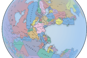
About Trade In The High Middle Ages
Even before the modern era, the Afro-Eurasian world was deeply interconnected through trade.
This map illustrates the major trade routes of the High Middle Ages—situated after the decline of the Vikings, before the rise of the Mongols and the Hansa, and well before the Portuguese navigated around the Cape of Good Hope.
Beyond trade routes, the map also depicts general topography, major rivers, mountain passes, and named trade paths—all of which played a crucial role in shaping the locations of cities, many of which remain significant to this day.
The High Middle Ages marked a golden period for commerce in many regions.
In Central Europe, German and French cities began hosting annual trade fairs, some of which, like Frankfurt’s, continue today.
The Crusades in Iberia and the Levant reignited European demand for eastern goods, and Italian city-states—along with some north-eastern Iberian cities—developed powerful fleets to transport crusaders across the Mediterranean.
These fleets evolved into commercial networks, linking Mediterranean ports. Italian merchants, for instance, frequented Alexandria, where separate trading zones existed for Christian and Muslim ships.
Southern Iberian Muslim kingdoms maintained strong trade ties with Egypt, and one of the most crucial maritime routes connected Seville and Alexandria.
Along this route, Palermo in Sicily became a key meeting point for Christian and Muslim traders, with Jewish merchants often acting as intermediaries between the two.
This period also witnessed the rise of the Sahelian trading cities, located just south of the Sahara. These cities became the world’s primary gold suppliers, fueling markets across Afro-Eurasia.
It was from here that Mansa Musa (Keita I) would later embark on his legendary Hajj. Gold was primarily transported northward across the Sahara to North Africa, with an emerging eastward trade route linking it to Egypt and Sudan.
Further east, the Fatimids of Egypt and the Abbasids of Iraq competed to control lucrative trade flowing through the Nile and the Euphrates. The Nile eventually proved the superior route, as the Persian Gulf was increasingly plagued by piracy.
In what is now Russia, the region’s numerous navigable rivers continued to serve as vital trade arteries, even after the decline of Viking incursions. Russia remained a key supplier of furs to both Europe and the Muslim world. These Russian trade networks connected to the broader Silk Road, serving as a gateway for goods moving westward.
The Silk Road:
Contrary to its name, the Silk Road was not a single route but rather a complex network of trade paths extending across Asia—from Constantinople in the west, through Central Asia and the Himalayas, to Liangzhou in the east.
During this period, China’s Song Dynasty was at its zenith. It embraced foreign trade, investing heavily in commerce and infrastructure. Foreign traders, including Jewish and Muslim merchants, primarily operated from the empire’s southern ports, where they had established thriving communities.
Maritime Trade in Southeast Asia:
In the Indonesian archipelago, the Srivijaya Kingdom, based on Sumatra, was the dominant maritime and commercial power.
However, it faced fierce competition from rival trading states on the neighboring island of Java. This region supplied exotic spices highly sought after in both the Muslim and European markets.
India: A Central Trade Hub
India had long been a cornerstone of Afro-Eurasian trade, serving as the primary source of exotic goods and spices. During this era, the Chola Dynasty of southern India was expanding its influence, reaching as far as Sumatra.
The Cholas combined military conquest with commercial enterprise, establishing trade factories and networks wherever they exerted control.
East Africa: A Rising Trade Force
Although East Africa had yet to reach its peak in this period, it played a crucial role in supplying the Indian Ocean trade network with gold, slaves, and exotic animals.
The most prominent trade route led from inland Zimbabwean cities to the coastal city of Kilwa, which became a major hub for gold exports.
Enjoy this map? Then please help by sharing it:


Tim Kaminski says
Zadar and Nin are on the coast of the mainland, not on the outer islands. On the East shore of the Adriatic, now in Croatia. Cool map.