The European Union’s (EU) 28 member states vary enormously in population. From tiny Malta with just 425,000 people to Germany with 81 million. But what if they all had the same population? How would the map look?
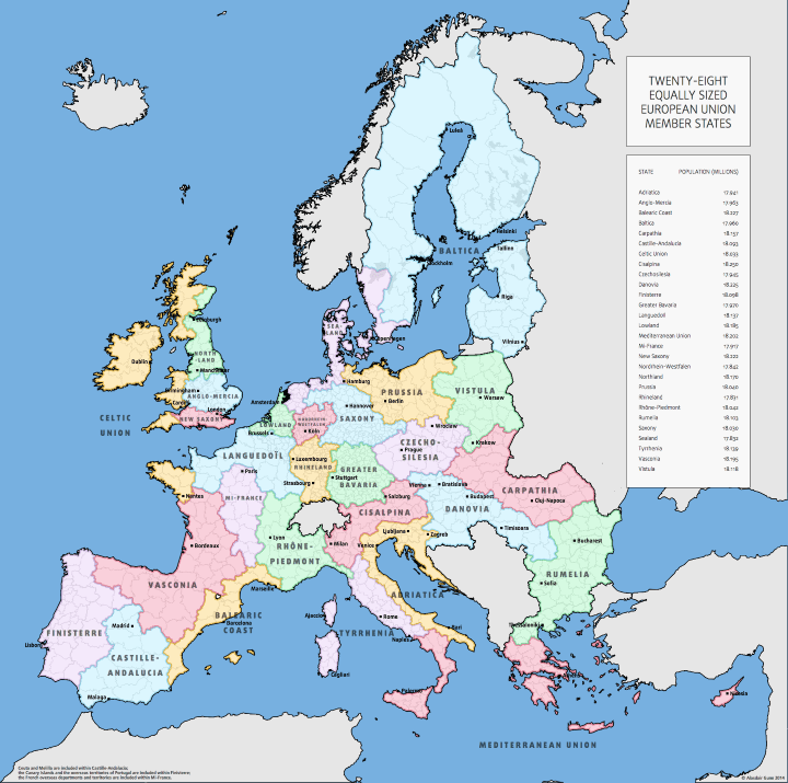
As you can see above, if all EU members had the same population, they’d each have around 18 million people or slightly less than the current population of Romania.
Alasdair Gunn, who made the map, is quoted in BigThink as stating that “[it] is NOT intended in any way to represent meaningful units of government, at any point in time. This map was made (1) for fun and (2) to draw attention to the massive imbalance between member states at the Commission level.”
However, he’s come up with some interesting country configurations including:
- The return of Prussia, Bavaria and Saxony to the map which all ceased being independent countries following the unification of Germany in 1871.
- New Saxony in Southern-England with London as its capital.
- The Celtic Union roughly Brittany, Cornwall, Devon, Ireland, Wales and western Scotland.
- The Mediterranean Union which includes parts of Greece, and Southern-Italy along with Malta and a reunified Cyprus.
- Czecho-Silesia
- Baltica
- Balearic Coast, or a potential home for Europe’s Catalan speakers.
Finally, if you look at the notes at the bottom of the map you’ll see that France’s overseas departments are included in Mi-France, which just happens to be landlocked.
What country do you live in now? Share your new nationality with your friends:

erik smit says
And the brilliant thing is that the big gap in the Balkan could join as a whole.. or almost. They’re at 16,5 million inhabitants.
CortexUK says
Oh ffs, don’t give the EU any ideas…
flamenco108 says
I support. I think many Polish people would react allegically on such a sort of jokes… Especially, that division of the Poland was made on old borders from time, when our country was partitioned very similar way as it’s shown on the map. The only ethnic Polish part left is Vistula, that consist only rural areas with ruined infrastructure still in reconstruction. This would make this region quite peripheral, third world. Bad idea.
blair houghton says
France is a lot less populated than I thought.
Bruno Teixeira says
Please please please make the same with GDP. That’s where it will start to get interesting.
Marc says
Ha .. Nordrhein-Westfalen just remains what it is already. So for me nothing would change 😀
Peter says
Interesting from a historical perspective, but culturally a disaster. I think the map is a good demonstration that new borders won’t really solve issues but only create new ones. Through that it makes a strong point on rethinking borders, as the EU already did with Schengen. Maybe that map could be used in a political context where population count matters a lot to the outcome, i.e. in a representative vote in which electors would come from regions like Danovia or Vasconia. Though I can’t think of a vote that wouldn’t be a question of culture..
mP says
Im going to say that a Europe with 100 countries would be a far happier place than today with mega countries.
TotusMappus says
You know, I designed a map once that was meant to consolidate Europe into as few countries as possible, and also piss off nearly everyone in Europe while I was at it. The semi-historical borders, the old names, the disregard for culture, language, or relative wealth.
This is that same map, but based around population rather than nationalistic consolidation.
Peter Kurilecz says
now do one based upon language
Hans Versluys says
The UK having left the EU would necessitate an interesting change to the map. The Celtic land would have to merge with more of France (maybe even the Basq county). Kaliningrad will eventually be Prussia. And the Balkans may ne one entity based on population. Greece would have a word though about losing Macedonia despite getting Magna Grecia back.