It’s famous for its monumental stone statues called the moai and has a fascinating history of rise, transformation, and resilience.
A Brief History of Easter Island
Settlement and Early Society (c. 1200 CE)
- Polynesian voyagers (likely from the Marquesas or other eastern Polynesian islands) settled Rapa Nui.
- They developed a complex society with clans, agriculture, and religious traditions centered on ancestor worship.
The Moai Era (c. 1200–1600)
- Hundreds of moai statues were carved from volcanic stone and placed on ceremonial platforms called ahu.
- These statues likely represented deified ancestors and were believed to protect and bless communities.
Ecological Stress and Change (c. 1600–1700)
- Extensive deforestation (for agriculture, transport of moai, and fuel) led to environmental strain.
- Social tensions rose, and many moai were toppled during conflicts.
The Birdman Cult (Late period)
- A new religious system centered at Orongo replaced moai worship.
- Leaders competed in dangerous rituals involving retrieving the first seabird egg from nearby islets.
European Contact and Aftermath (1722 onward)
- First recorded European arrival: Jacob Roggeveen on Easter Sunday (hence the name).
- Later visits brought disease, slavery, and population collapse.
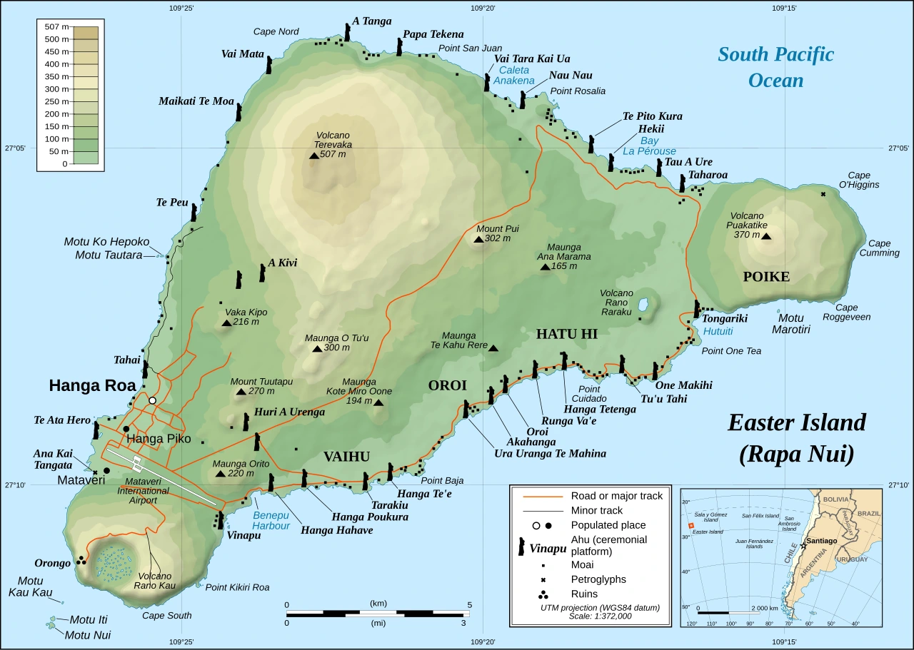
Key Geographic Features
Terevaka: The Island’s Highest Point
- A shield volcano and the highest point (~507 m).
- Offers panoramic views of the entire island.
- Represents one of the three main volcanic formations that created the island.
Poike : The Oldest Volcano
- The oldest and most eroded of the island’s volcanoes.
- Forms the eastern part of the island.
- Less fertile and more barren compared to other regions.
Rano Kau: A Spectacular Crater
- A massive volcanic crater with a freshwater lake inside.
- Covered in floating vegetation mats.
- One of the most dramatic landscapes on the island.
Motu Nui: Sacred Islet of the Birdman Cult
- Largest of three small islets off the southwest coast.
- Central to the Birdman (Tangata Manu) ritual.
- Competitors swam here to retrieve the first sooty tern egg.
Orongo: Ceremonial Village
- Located on the rim of Rano Kau crater.
- Stone houses and petroglyphs related to the Birdman cult.
- A major ceremonial and political center in later history.
Mataveri: Gateway to the Island
- Site of the island’s only airport (Mataveri International Airport).
- Near the main town, Hanga Roa.
- Also contains archaeological alignments possibly linked to astronomy.
Ahu and Moai: Sacred Platforms and Statues
What are Ahu?
- Ahu are ceremonial stone platforms.
- Built along the coast, often facing inland toward villages.
What are Moai?
- Large stone statues carved mainly from volcanic tuff.
- Represent ancestors and spiritual guardians.
Major Ahu Sites:
- Ahu Tongariki: Largest platform with 15 restored moai.
- Ahu Akivi: Unique inland-facing moai.
- Ahu Nau Nau: Located on Anakena beach, some of the best-preserved statues.
How Were the Moai Transported and Erected?
Most moai were carved at the quarry of Rano Raraku, then moved, sometimes several kilometres, to coastal ahu platforms.
How they did this has been debated for decades.
Theory 1: “Walking” the Moai (Most Supported Today)
- The statues were kept upright.
- Teams used ropes attached to the head and sides, rocking the statue side-to-side.
- This created a forward “walking” motion.
Evidence:
- Oral traditions say the moai “walked.”
- Modern experiments (e.g., by archaeologists like Terry Hunt and Carl Lipo) successfully moved replicas this way.
- Many fallen moai along roads lie face-down, consistent with tipping during upright movement.
Theory 2: Sledges and Rollers (Older Idea)
- Moai were laid horizontally and dragged on wooden sledges or rollers.
- This would have required large amounts of timber.
Problem:
- Rapa Nui was heavily deforested, there likely wasn’t enough wood for this method at scale.
Final Step: Raising the Moai onto Ahu
Once at the platform:
- Builders likely used ramps of earth and stone.
- The moai was gradually tilted upright using levers, ropes, and stones.
- The red stone “topknots” (called pukao) were added afterward.
The Birdman Ritual (Tangata Manu)
After the decline of the moai-building era, Rapa Nui society shifted to a new belief system centered on the Birdman cult.
Where It Happened
- Main site: Orongo
- Overlooks the ocean and the islet Motu Nui
The Annual Competition
Each year:
- Representatives of different clans gathered at Orongo.
- Competitors (called hopu) climbed down steep cliffs.
- They swam across shark-filled waters to Motu Nui.
- They waited for the first egg of the sooty tern (manutara).
Winning the Title
- The first to return with an unbroken egg made their sponsor the Tangata Manu (Birdman).
- The Birdman gained political and religious authority for the year.
Cultural Meaning
- Represents a shift from ancestor worship (moai) → competition and ritual power.
- Likely emerged during times of resource scarcity and social change.
Why These Two Topics Matter Together
- The moai system reflects a highly organized, cooperative society focused on ancestors.
- The Birdman cult reflects a later, more competitive and adaptive system.
Together, they show how Rapa Nui society evolved in response to environmental pressure and internal conflict.
Want to learn more about Easter Island? Then have a look at the following books:
- The Mystery of Easter Island: The Story of an Expedition
- The Statues that Walked: Unraveling the Mystery of Easter Island
- Island at the Edge of the World: The Forgotten History of Easter Island


Leave a Reply