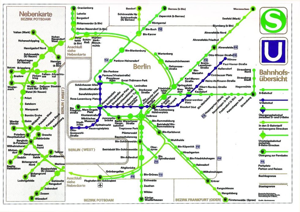
However, if you look closely, you might notice something’s missing.
And that something is of course West Berlin, which had it’s own U-Bahn and S-Bahn lines (although you wouldn’t know from this map). The reason of course is rather simple, East Germans could not travel on the West Berlin lines so why show them?
Instead the map (nearly) erases West Berlin by showing an insert of the Potsdam area (which was in East Germany) instead. Of course prior to the construction of the Berlin Wall in 1961 both networks had been integrated.
However, after the Wall each one was almost entirely cutoff from the other, creating a series of ghost stations.
The one interesting exception was Berlin-Friedrichstraße station, which while in the East, also allowed West German travellers to transfer between lines. However, East German citizens were cutoff from the sections of the station that allowed travel to the West by a metal-glass barrier.
In effect, Friedrichstraße was a microcosm of the situation in Berlin.
It’s also interesting to see how West Germany dealt with this issue as the map below illustrates.

If you like this map you’ll probably also enjoy: 1988 East German Map of West Berlin
And here are a few other maps from when the City was divided.
1987 Map Of The East German View of the Berlin U & S-Bahn Network

On these maps, the wall is shown quite distinctly, and West Berlin is essentially eliminated from view. The area immediately west of the wall is obliterated by an overlaid “Nebenkarte” (inset map) of Potsdam, a city just west of West Berlin controlled by the DDR.
This cartographic approach “takes the prize for sheer barefaced nerve by crafty design, the whole of West Berlin and all its train services are squished up so that it virtually disappears, and even the trains around the left edge . . . appear, at first glance, seamlessly stitched into a continuous East Berlin network.” Ovenden 2011, 39.
The tiny remaining areas between the wall and the Nebenskarte are labeled “West Berlin” – in contrast to, and smaller type than, the label of the central map, “Berlin.”
Transit lines are shown terminating to the east of the wall, and there is no indication of West Berlin U-Bahn trains running through East Berlin stations – “ghost” stations, where they were not permitted to stop – between two points on the western side of the wall.
1967 West German Map Of The Berlin U-Bahn Network

[The map] shows the entire subway system, East and West, and the wall is extremely faint. The legend indicates markings for “Stations where the trains do not stop” and “Stations that can be reached only using the trains of the BVG East.”
1984 West German Map Of The Berlin U & S Bahn Network

Enjoy these maps? Please help us by sharing:


Paul Prescott says
Note that the West German map shows only the U-Bahn lines and not the S-Bahn. The reason for this is that the S-Bahn lines throughout the city were owned by the East, and so patriotic West Berliners completely shunned them, even though the ticket price was lower.
Anonymous says
That’s partly right. in 1984, the GDR was no longer willing to cover the losses of the West Berlin S-Bahn network. And the GDR also no longer needed to have control over rail infrastructure in West Berlin because the GDR no longer needed send transit trains through West Berlin.
Therefore, Ulbricht gave in and agreed to hand the West Berlin S-Bahn network over to BVG-West. BVG-West continued to operate the service until 1990.