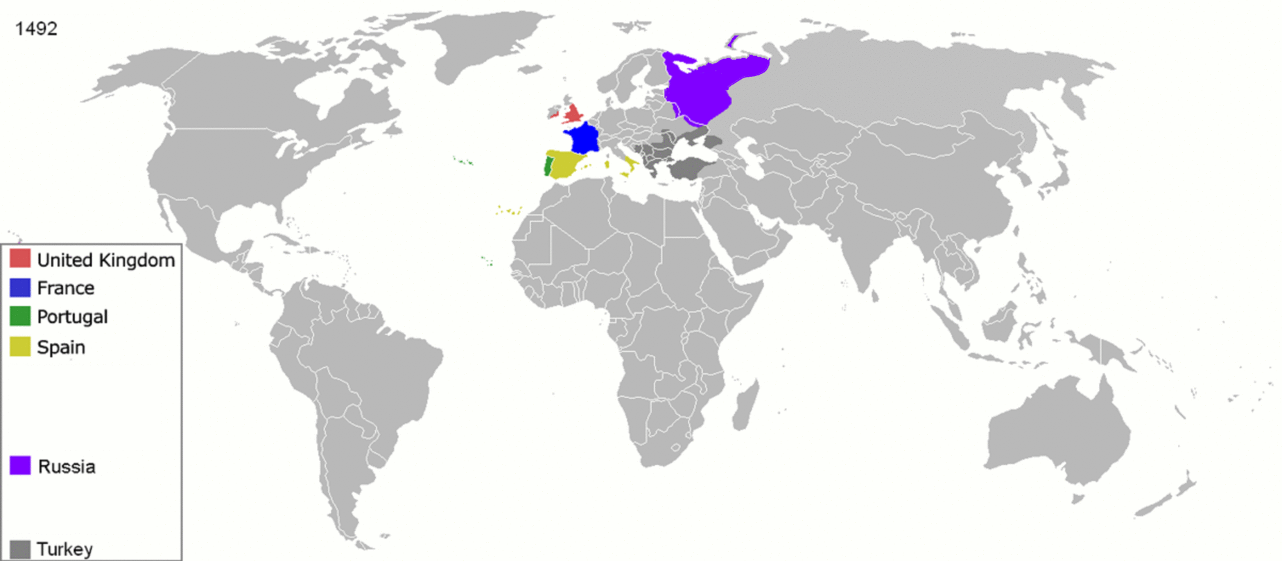
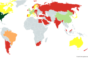
The map above presents a very short history of colonialism around the world from 1492-2008 in one simple GIF. Interestingly, it doesn’t limit itself to European colonialism but also includes the colonial empires of the United States, Russia/Soviet Union and Japan.
It includes the borders of the following colonial empires:
- British Empire
- French colonial empire
- Portuguese Empire
- Spanish Empire
- Russian Empire & the Soviet Union
- Ottoman Empire
- Danish colonial empire
- Dutch Empire
- American Empire
- Belgian colonial empire
- Italian Empire
- German colonial empire
- Empire of Japan
In total 11 snapshot years are looked at. They are:
- 1492: The year Columbus “discovered” the Americas.
- 1550: The start of the Valladolid debate
- 1660: Start of the English restoration.
- 1754: The eve of the Seven Years’ War, known as the French and Indian War in America. One of the first wars fought around the world.
- 1822: Brazil declares independence from Portugal.
- 1885: Berlin Conference formalizing the Scramble for Africa.
- 1914: The eve of World War 1.
- 1938: The year before World War 2 breaks out in Europe, although World War 2 in Asia had already begun.
- 1959: The year before France grants independence to its remaining French colonies in Africa.
- 1974: The year before Portugal recognizes the independence of Mozambique and Angola.
- 2008: The year the map was originally made.
If you’d like to learn more about colonialism the following books may be of interest:
- Empires in World History: Power and the Politics of Difference
- Guns, Germs, and Steel: The Fates of Human Societies
- Why the West Rules–for Now: The Patterns of History, and What They Reveal About the Future
- The Birth of the Modern World, 1780-1914
- Discourse on Colonialism
Enjoy this map? Then please share with a friend:


strad77 says
Finally a GIF map that doesn’t zoom by so quickly!
Boby moor says
Russia in 1492??? Russia didn’t exist before 1721.
Bill Planey says
You have got to be kidding? Peter I (who was not even the first Tsar) ruled from the 1690s-1725.
captain obvious says
lol.what an idiot. Ancient Rus’ has existed since 862.
Omar says
Ethiopia was an independent state for over 3000 years
S C says
The final maps, post 1950s should show Australia, NZ as deep red (English settler colonialists), and USA, Canada in different colors of the Europeans who colonized and settled on native lands. Could someone please correct this important gif map, thank you!
Neil says
Agree, but perhaps in a different color: ‘legacy of colonianism’. It needs to be extended to South & Central America too.
Ilyas Tarar says
What has the white man doen to the humanity!!!
captain obvious says
Spaceships, nuclear power plants, the Internet, etc.
Hjwiakl says
“1754: The eve of the Seven Years’ War, known as the French and Indian War in America.”
Calling US as America kind of reveals the nationality of who’s writing. Congrats, dear American, for caring about the history of other places!! How sweet (:
I know: it is a lot of stuff to know! The world is biiiig. Maybe now it would be great to start referring to your country by its name and not by the whole continent, huh?
Oahu Sumo says
OK buddy 🙂 Thanks for the patronizing—I mean thoughtful—words.
Goat says
interesting illustration. One inaccuracy I see is that Nepal was never colonized by the British (or anybody else).
Miranda says
The map displays some British colonies as being independent at the 1974 snapshot, which is inaccurate as some former British colonies gained independence as late as 1980 (e.g. Zimbabwe)
The Majoo says
ivan the great was ruler of russia during that time 😒
jeffo says
history kinda boring ya’ll
poopoomcturdus?? says
Imagine living in one of the 96(!!) Roman provinces under Diocletian….
Like, how awesome it must’ve been!!:):):):)!!