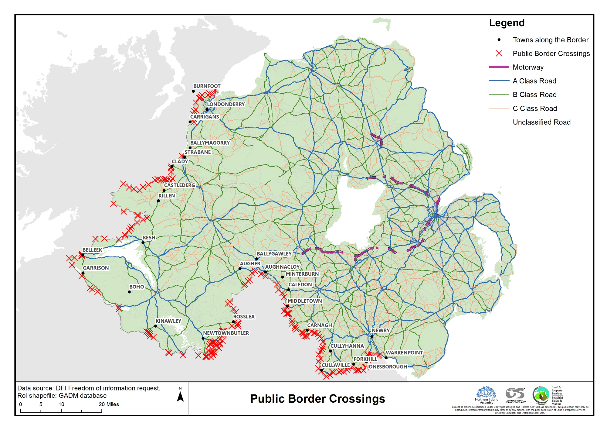
The map above shows 195 public road border crossing points between the Republic of Ireland & Northern Ireland.
In total, there are somewhere between 208 and 275 public border crossing across the 499 km (310 mi) border.
What’s amazing is that this is both more than the 137 land border crossings to the east of the EU. And far more than the 119 border crossings that exist between Canada and the United States, the world’s longest international border (8,891 km [5,525 mi]).
While both Ireland and the UK are in the EU, the issue remains more or less a moot point. It’s more or less an open border.
However, if the UK actually goes ahead leaves the Customs Union and Single Market it can’t be.
With that in mind, it’s easier to see why the border issue is such a sticking point in the Brexit negotiations between the UK and the EU. Despite Brexiters’ claims to the contrary, the border issue is anything but easy.
And to put things in a little historical perspective, during the Troubles only around 20 of the border crossings remained open, or less than 10% of the current total.
It would be such a shame to throw away all that progress.


PJ says
“throw all that” not “through all that”
Brilliant Maps says
Corrected.
Frédéric Pauzat says
Qu’en est-il de la frontière entre Gibraltar et l’Espagne ?
What about Gibraltar and Spain ?
Qual es el porvenir de la frontera entre Gibraltar y España ?
Ray says
You do not have all the roads and crossings shown in west Fermanagh? I know a lot more than you show
Gordon says
Yes Ray, and the road North of Tullyhoman cross in and out of Donegal several times before back into Fermanagh and Tyrone and in to Castlederg.
Martin Lunnon says
Isn’t there also a crossing where the ferry goes across the mouth of the Foyle?
Lifebuoy Ghost says
Yes, Magilligan Point in the North to Greencastle in the South, Donegal. Nor running at present.
Sam Carruthers says
“Despite Brexiters’ claims to the contrary, the border issue is anything but easy”. The border issue is absolutely easy! There are two jurisdictions on the island of Ireland. One is the UK and the other is the RoI. The RoI is an EU member and the UK is not. EU checks are the responsibility of EU members not non-EU members. If we don’t want checks on the RoI-UK border then we can have checks away from the RoI-UK border. It’s absolutely easy!
• Electronic Declarations and Pre-Clearances.
•Trusted Trader Schemes
• Mobile Inspections
• Remote Inspections
• Blockchain Technology
Just a few examples of the technologies that can be used to do checks away from the UK-RoI border.
If the EU wants to be a fanny about it that’s their problem. But the UK has ALREADY shown the EU how checks can be done away from the border as the UK is already doing checks away from the UK-RoI border. It’s being done NOW as I type! So let’s not pretend it’s not easy!!!