
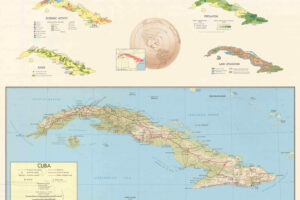
The map above shows an incredibly detailed map, in English, of the Paris Catacombs. It appears to have been made by a French company called CUBE that no longer seems to be in business.
Here is some of the extracted text (note this was done by software so may have some errors). You can read the map in full by clicking on it above:
First a note: Warning Accessing these underground galleries is forbidden by the French legislation. Trespassing and circulating into these places can be punished by high fines. The exploration of these galleries present lot of dangers. Having a map is not enough to avoid them all. These hazards can even be fatal, caused by wells, due to falling of persons or objects. Hazards of collapses caused by carelessness or by ignorance of the places. Lighting an open fire can be fatal. Trespassing into a quarry put you inevitably in serious trouble possibly leading to severe. complications due to the inaccessibility of possible rescuers.
These quarries are also part of our underground heritage. These places are fragile. They contain a lot of historical or geological remains, ancient writings and signs that must be protected. Respect these places. Do not leave garbage in the galleries, do not pollute these locations by paintings.
Map of the Paris Catacombs and underground quarries, Great Southern Network
FROM SEA… TO STONE
Giving this place the name of “catacombs” is at once true and false. To understand this place, let us go back far, very far into the past, to the creation of the subsoil that will become the underground later on…
The origin of these places starts around 250 million years ago, in the region located around the Parisian basin, periodically covered by the ocean. The floating particles – alluvial sediment, organic wastes, shells- will be slowly deposited during these marine cycles of salt and fresh waters, and, little by little, form different layers. This geological and chemical process will form the rock beds which will create hard strata of differing qualities and materials, depending on era. In some places, sand will be formed. In others, one will find chalk or gypsum. What we find here will be a 40 metre layer made of “Lutécien limestone”.
HUMAN KIND AND THE DISCOVERY OF THE EARTH’S WEALTH
This stone will remain untouched for millions of years, covered little by little by earth, organic wastes, sand or stone at differing elevations depending on the relief and local geographical events. Then will come the appearance of human kind who will slowly discover the wealth of the Earth, using the surface layer for agriculture. While digging it, they will learn to use the different materials available, like peat, lignite, coal, chalk, clay or gypsum for domestic uses: pottery, mortar, heating or culture. The discovery of limestone will lead to the discovery of construction stones, an essential element of housing construction and the creation of solid and lasting buildings.
OPEN AIR MINING
Natural cavities which were first used as shelters will introduce their inhabitants to the use of raw materials originally found on cavern floors to build the very first primitive housings. But the real mining of the rock deposits of the Parisian basin will officially start in the Gallo-Roman period. The surface layers of limestone will first be exploited in the places where cover layers are thinnest, in order to extract the first blocks with very basic means: pickaxes, “spears” (long iron sticks), levers, ‘roules’, and carts. These “open-air” excavation techniques are little productive, use only a small part of a varying quality of limestone and produce considerable amounts of waste, but still remain economically viable because of the ease of their implementation.
FROM GROUND TO SUBSOIL
The open-air mining of the most accessible surface rock beds will continue until the XIIth century. These surface layers will be followed deeper and deeper into the earth. As the quantities of earth to remove become too unwieldy, a new technique will appear: underground rock mining. In these huge pits, humans will start to dig galleries in which access is made through very wide entrances: so-called “cavage” entrances.
After an improvement of this technique, blocks are removed by layers using as much as possible the natural vertical cracks. These cracks are enlarged on each side using spears, pickaxes or wedges allowing the exact demarcation of the width of the block that will be extracted: this is known as “défermage”. In this same way, the hard horizontal strata are used to separate blocks from the limestone bed. The extremely soft and thin layer called the “souchet” can be easily dug, and will give its name to this technique: “souchevage”.
THE GENERAL INSPECTION of the QUARRIES (IDC)
Numerous disastrous collapses will lead to the royal decision to take into account this problem. The Inspection des Carrières (quarries inspection) will be created in 1777 to inspect each gallery, to reinforce these underground cavities and to map them. Little by little, stone extraction will be forbidden in all the quarries.
This is the dawn of a new era where the fragile and anarchic cavities will be transformed into inspection galleries as they can be seen nowadays. The Inspectors and their workers (carvers, architects, team leaders) will build countless high quality stone works: finely wrought staircases, corbelled or vaulted galleries, arches, and fontis reinforcements. Hundreds of wells will be drilled for service needs or to test subsoil rock layers; countless research galleries will be dug into the underground rock mass.
It will take ten years to drill Assas Street alone. During the next 150 years, these inspectors and their team will remain the lone authority of a unique and invaluable architectural heritage which will remain unknown until the underground quarries are transformed into… the Parisian catacombs.
THE PARISIAN CATACOMBS
At a time when the problems of the underground are close to being solved, another
the graveyards are overloaded, mass graves grow in number – the living and together that Parisians of the day say that their bread and water tastes like royal administration will ask the IdC to solve this public health problem; use the underground cavities to build a General Ossuary. Almost 75 years will total contents of the Capital graveyards: six millions corpses will be stored in necropolis. The Catacombs are thus born, and become a place of fascination development done by the quarries inspector Louis Héricart de Thury will form what is still known today as the Catacombs museum.
Once it has been through “défermage” and “souchevage”, a several ton block will just fall by the force of its own weight, or with the help of wedges. Using wood logs, this limestone block will then be moved on ground levelled into a soft slope leading to the surface, where it will be taken out by manpower, then pulled by animals.
The workers can now be considered quarrymen, mining underground stone. The raw material, still wet, can be easily cut into stones, dried to harden, then cut to be used in construction. Under the ground, the cavities expand and will become galleries; excavation sites will become “workshops”.
Arched and low
is generally mined by circular extraction turning around a central rock mass from which blocks are extracted until only the core remains. This core will then become a massive pillar used to bolster newly created cavities in what is known as the “turned pillar” technique. As mining extends further and further from the entrances, the transportation of the stones to the surface will be made easier by digging additional pits, which will later on become wells from which the precious stones will be extracted using winches…
LIFE IN A QUARRY.
As extraction progresses, the quarry becomes an anarchic collection of cavities, winding through the turning pillars. In some spots, concessions are given to others who use their own teams of workers that sometimes live and sleep at the work place. Accidents are numerous and frequent. While workers are often crushed to death by rocks, or fall into wells equipped only with fragile wooden ladders, they are also at risk from score settling by other workers, diseases and infections. Sullied water from the surface pours into the underground; the leads to blindness. These difficult conditions, however, discourage few have strength of both mind and body. People from Northern and
regular income that doesn’t depend on the seasons or the climate.
The lack of natural light and the rustic lighting Anybody can do this work, as long as they Eastern France, mainly farmers, come to find wages may seem ridiculously low, but they are still higher than those of above-ground workers, as quarrymen are paid by piece, and good limestone fetches a high price.
At the beginning of the XXth Century, the golden age of the IdC fades out. The monumental works are finished, the quarries Atlas showing the complete plates of the Paris undergrounds and all the suburbs is almost completed. The IdC will thus enter the modern era. The period leading up to the 50’s is a chaotic one, which will see two wars that will indelibly mark the history of the catacombs.
From this point on, the number of plates marking consolidation work will become so numerous they will no longer be counted. During these times, the galleries will only be used by a few initiates. Activists from the revolutionary group La Cagoule (CSAR), an extreme right party, will use underground spaces as staging grounds for destabilizing actions and attacks against the Republic. Assigning names to the underground rooms by letters of the alphabet, they will give the name of “la Salle Z” (room “Z”) to a site that is still well-known today by the same title.
THE WAR YEARS
The 40’s are marked by the use of the underground quarries to build civil defence shelters: Cochin, Val de Grâce, Laval, Faco and in the XVth district, what will become known later as the “Flag room”. While the German occupying troops will build the wide galleries of the German Bunker of the Lycée Montaigne, the Resistance will also use the underground to build the HQ of the Free French Forces. During this time, civilians will also occasionally travel through the rest of the network: for black market work, secret good storage or to access cellar space. Others undoubtedly find the catacombs to be a restful haven or a domain for adventure, like the Doctors Suttel and Talairach who will be the pioneers of the modern “cataphile” era with their underground explorations.
FROM THE CATACOMBS… TO THE CATAPHILES.
RUE DES LOTS
Gren plus probably carved en these plots of land divided. by anyone who is interested about the undergrounds constitution. For the cataphiles, they were used as a basis for drawing the first maps. They were only wired diagrams showing only a basic drawing of the galleries, as for instance Mr Suttel’s map, drawn at a MOUTON rough guess” during the explorations. These orientations maps give only the essential to go from one place to another.
Some of these maps reach a surprising level of precision, like the ones from Mr Munier or Titan based on IdC in the 80’s, which format has been kept here to keep the unity of the different networks (14th, 15th, 5th and 6th arrondis- sements). The Giraud map compiles these different version from 1983 to 1989 into a compact version adding the width of the galleries, and numerous precisions such as the wells, and the main streets above the surface. Finally, the Lafouine editions from 93 to 2000 bring a remarkable legibility by the computer and color format.
Most of these nomenclatures have been kept here to add precise statements of the signs ad complete, updates onsome areas. On top of that one can discover layout of old and forgotten galleries as well as many historical precisions, a synthesis of the many researches performed since 2001
The 50s and 60s will see new visitors appear. Students from the Universities of Pharmacy & Medicine, as well as the Grande École of Mining Studies, will find here a great location for parties, easily accessible yet well-hidden. More and more explorers are attracted by the underground, leaving the parties that initially brought them down to explore further this unknown territory.
Exploration groups are formed and walk all over the network. These groups are known to us mainly thanks to rare publications on this topic, and to the copies of early maps made by students of the Grande École of Mining Studies, which will form the basis of the first “Cataphile” maps. The years 68-70 will continue in this spirit of freedom and exploration, with the underground attracting more and more clandestine visitors who will have to learn to coexist with the newly reborn IdC and the police forces that were once relatively passive in regard to underground activities. The underground of the 80’s will form the basis of the network we know today. The north and the south are split into separate sections by the IdC: access points are walled-up. Tags appear everywhere and rooms and galleries are vandalized.
The Capuchins quarry is isolated and, like the municipal ossuary, becomes inaccessible from the main network. Finally, a large part of the Montsouris district disappears with the gallery “du chemin de l’échelle” and the closing of the underground water reservoirs. In the 90’s, the construction of the integrated Montsouris development zone will cause the disappearance of a high number of small ancient galleries, which are injected with concrete during the work: In hardly half a century, the quarries went from the stone age to the concrete age.
Underground quarrying carries a different kind of price. Newly dug cavities create new dangers. While extending the depths of the mining operations, galleries weaken, stones crack and collapses become more and more frequent. Rock layers that hold together and overlap are likely to collapse at any time, held together only by the pressure from the turning pillars, set at random places without any specific plan. But these cavities reveal another threat, a geological phenomenon with unpredictable and unexpected consequences known as the “fontis”. In the core of these different rock layers, a fissure will sometimes appear, crack and create a small collapse that will irremediably increase to create a bell-shaped dome: the “fontis bell”. This fissure will eventually reach the surface, creating a mound of pieces of fallen rocks at its base from this natural well. When it reaches the surface, it creates a huge collapse but also a powerful blow while crashing under ground, compressing the air in the galleries and spreading like the blow of an explosion.
THE GREAT UNDERGROUND QUARRIES OF PARIS
Ladder leading to lower level corridor which dead ends
Underground life in the Parisian quarries will not change much from the XIIth century to the XVIIIth. Men will dig ever deeper, using this stone to build more and more buildings and monuments. Religious orders will build cloisters, churches and cathedrals of these materials. The quarrymen will extract more and more blocks, creating more underground cavities, punctuated with numerous collapses and ‘fontis’ that will engulf both men and their constructions, again and again. Above the surface, Paris extends, grows and builds its foundations over immense cavities, networks and galleries which are unknown to most yet nonetheless significant to the life of the growing city.
Below the southern part of the capital alone this area will reach almost 800 hectares divided amongst 7 districts. Later on, a writer will express the reach of the underground, saying: “All you have to do to know the extent of these quarries to consider that everything that stands above the surface of the ground is no longer below the surface”. During these 5 centuries, only a few monuments will receive specific reinforcements.
Aside from the reinforcements of the Carthusians, pioneers in this field who will start solidifying the underground section of their monastery in 1250; and the reinforcing work of François Mansart, who will be asked to start an important series of works below the Val de Grâce in 1615, Paris is shakily perched on a void held up only by random stone pillars of variable reliability.
The modern era of the underground will begin in the XVIth century. A new technique will appear, coming from Italy, called “Hague et Bourrages”. This very simple process consists of infilling the cavities using waste from extraction, backfilling the void up to the quarry ceiling. These masses are solidified by “arm pillars”, made of large blocks aligned in regular spaces, linked together by much smaller “dry stones”: the so-called “Hagues”. The cavities are thus reinforced and do not present any risk of collapse; on top of that, a great part of the mining waste is reused by this process in order to fill up already excavated spaces, creating a convenient access gallery. This huge technological advance will allow the quarrymen to more easily extract the deposits, by drilling wells to reach the best quality limestone (the hardest ones to reach), to extract them, then to efficiently solidify the cavities.


Leave a Reply