Brilliant Maps

Making Sense Of The World, One Map At A Time

  • BOOK!
  • Newsletter
  • Board Games
  • Posters
  • Scratch Maps

North American Maps for Curious Minds

Last Updated: March 3, 2023 1 Comment

Click To Get My 10 Best Brilliant Maps For Free:

North American Maps for Curious Minds

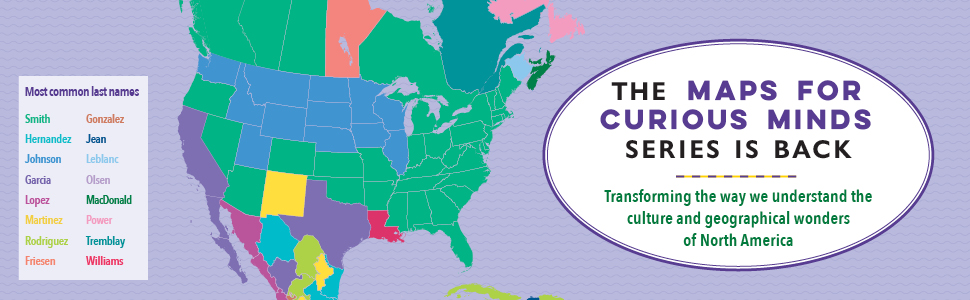
I’m very please to announce that The Maps for Curious Minds series is back—with 100 vivid infographic maps that transform the way we understand the cultural and historical wonders of North America.

North American Maps for Curious Minds was written by Matthew Bucklan and Victor Cizek and illustrated by Jack Dunnington with a foreword by me (Ian Wright).

Find out the answers to the following questions:

  • Where can you find the world’s tallest and steepest roller coasters?
  • Who is the highest-paid public employee in each state?
  • Where can you visit the world’s largest island in a lake on an island in a lake on an island?
  • Where can you find the world’s biggest geode?
  • Where can you find the world’s oldest, tallest, and largest trees?

and many, many more.

You can find out more about the book from The Experiment here.

And if you’d like to get your own copy, you can do so from the following stores:

  • Amazon
  • Barnes & Noble
  • Books-A-Million
  • Bookshop.org
  • Indigo
  • Powell’s
  • Workman

NA APage v2

Filed Under: Other

Click To Get My 10 Best Brilliant Maps For Free:


Other Popular Maps

  • Global Change In Population Between 1500 & 1600AD

    Global Change In Population Between 1500 & 1600AD

  • The Yellow Counties Have More People Than All The Counties In Blue Combined

    The Yellow Counties Have More People Than All The Counties In Blue Combined

  • 11 Best World Globes For Kids & Children

    11 Best World Globes For Kids & Children

  • The Incredible Shrinking Aral Sea 1960-2014

    The Incredible Shrinking Aral Sea 1960-2014

  • 4 Maps That Put China’s & India’s Populations Into Perspective

    4 Maps That Put China’s & India’s Populations Into Perspective

  • Roman Road Tube Map Circa 125 AD

    Roman Road Tube Map Circa 125 AD

  • What If the Scottish Flag Looked Like…

    What If the Scottish Flag Looked Like…

  • Top 10 Countries With The Most Islands

    Top 10 Countries With The Most Islands

Comments

  1. James D. Zimmerman says

    August 25, 2022 at 2:48 pm

    The map on pages 92-3, “Topping the Charts” should have Clarksville and Philadelphia identified for the Monkees’ “Last Train to Clarksville” (#1 in November 1966) and the MFSB and the Three Degrees’ “TSOP (The Sound of Philadelphia)” (#1 in April-May 1974), respectively.

    Reply

Leave a Reply Cancel reply

Your email address will not be published. Required fields are marked *

This site uses Akismet to reduce spam. Learn how your comment data is processed.


Product Reviews · World Atlas · Settlers of Catan · Risk · Game of Thrones · Coloring Books
Globes · Monopoly · Star Wars · Game of Life · Pandemic · Ticket To Ride · Drinks Cabinets
US Locations · UK Locations· Fleet Management
Copyright © 2026 · Privacy Policy · Fair Use, Attribution & Copyright · Contact Us
Follow Us: Newsletter · Facebook · Youtube · Twitter · Threads · BlueSky · LinkedIn · Instagram · Pinterest · Flipboard