
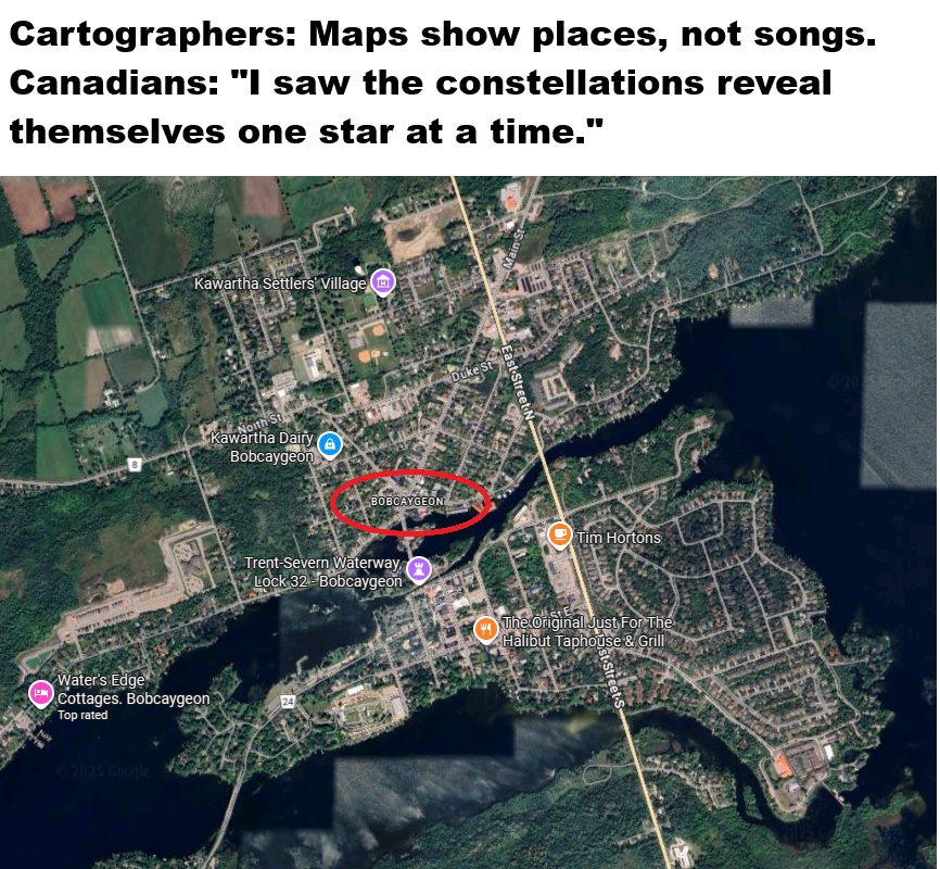
The map above shows the 100th Meridian West as it passes through Canada.
And the reason only Canadians will be able to hear it, is that it’s among the Tragically Hip’s most famous songs.
The Hip are relatively unique among Canadian bands in that they became extremely popular in Canada without any corresponding success in the United States or other countries around the world. This article from the BBC does a good job of summing up their success from an outsiders perspective.
Oh and you can listen to the song below:
Why is the 100th Meridian Important?
The 100th meridian west is a line of longitude running from the Arctic through Manitoba, the Dakotas, Nebraska, Kansas, Oklahoma, and Texas.
Environmental Divide
Historically, it has marked the major climatic boundary between:
- Humid, wetter regions to the east
- Arid to semi-arid regions to the west
This natural divide influences:
- Agriculture
- Settlement patterns
- Water use
- Ecosystem types
- Livestock vs. crop viability
This was famously emphasized by the geologist John Wesley Powell in the 19th century.
In both Canada and the U.S., the meridian roughly separates:
- Tallgrass prairie (east)
- Shortgrass prairie and steppe (west)
Why It Matters in the United States
Agricultural boundary
To the east, rainfall is generally sufficient for rain-fed farming.
To the west, traditional farming historically required:
- Irrigation
- Dryland techniques
- Lower-yield crops
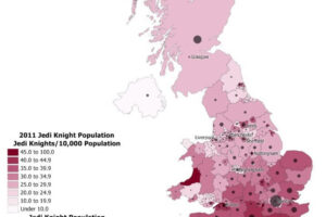
This is why the settlement patterns in the U.S. Great Plains thin out west of the 100th meridian.
As this population map shows:

Cultural and historical significance
American expansion, homesteading, and railroad settlement were deeply shaped by this line because it determined:
- Where farming families could survive
- Where ranching became dominant
- Where water law and use took very different forms
And here’s what the split looks like economically (using state lines):

Why It Matters in Canada
In Canada, the 100th meridian runs through southwestern Manitoba, and historically marked:
- The transition from parkland/boreal edge to dry prairie
- The eastern boundary of the Palliser Triangle, an area prone to drought and marginal agriculture
- Patterns of settlement on the Prairies

Like in the U.S., this line influenced what crops could be grown and where drought risk was highest.
How the Boundary Has Been Shifting Over Time
Climate change has effectively shifted the arid–humid boundary eastward.
Studies indicate that the climatic divide once associated with the 100th meridian has moved by 150–300 km (90–180 miles) eastward since the late 20th century, meaning it is now around the 98th meridian.

From the map above comes from Dividing line: The past, present and future of the 100th Meridian.
The 100th meridian runs from pole to pole, 100 degrees longitude west of the prime meridian in Greenwich, England. It cuts through six U.S. states, forming a partial boundary between Oklahoma and Texas. Powell identified this line as marking the point where the average annual rainfall dropped from 61 centimeters [24 inches] on the eastern edge to 46 centimeters [18 inches] at the western edge. New research shows a sharp aridity gradient still exists, but it’s moved east a bit, closer to the 98th meridian. Climate models predict it will move farther eastward in coming decades. Credit: National Atlas, modified by K. Cantner, AGI.
What does this shift mean?
Eastern areas are becoming drier
- Parts of the U.S. Great Plains (Kansas, Nebraska, Oklahoma) that once received dependable rainfall now experience more drought.
- Irrigation demands have increased.
Dryland crops are moving east
- Wheat and sorghum are expanding into areas previously dominated by corn and soy.
Canada’s Prairies are experiencing similar eastward dryness
- Southeastern Saskatchewan and southwestern Manitoba now show increased drought frequency.
- The Palliser Triangle’s climate characteristics are shifting deeper into Manitoba.
Ecological zones are migrating
- Shortgrass prairie species (e.g., sagebrush) are spreading eastward.
- Tree cover is receding in some regions where moisture is decreasing.
While doing research for this article I came across the following map of US counties on the 100th meridian from Twelve Mile Circle:

They are (from North to South)
North Dakota
- Rolette
- Pierce
- Wells
- Kidde
- Emmons
South Dakota
- Campbell
- Walworth
- Potter
- Sully
- Hughes
- Stanley
- Lyman
- Tripp
Nebraska
- Keya Paha
- Brown
- Blaine
- Dawson
- Frontier
- Gosper
- Furnas
Kansas
- Norton
- Graham
- Trego
- Ness
- Hodgeman
- Ford
- Clark
Oklahoma
- Harper
Texas/Oklahoma border
- Ellis, OK
- Lipscomb, TX
- Hemphill, TX
- Roger Mills, OK
- Wheeler, TX
- Beckham, OK
- Collingsworth, TX
- Harmon, OK
- Childress, TX
Texas
- Cottle
- Foard
- King
- Stonewall
- Jones
- Taylor
- Runnels
- Concho
- Menard
- Kimble
- Edwards
- Real
- Uvalde
- Zavala
- Dimmit
- Webb
And finally, returning to our original Tragically Hip refence at the beginning. Here’s one more bonus map:
And the song:


Rick Lawson says
I always enjoy the Brilliant Maps and their explanations. But here I must object! It is suggested that The Hip did not enjoy success outside Canada. Not true! I saw them at least three times in Paradiso, Amsterdam. The place was fully booked and the crowd knew their songs by heart. Like Justin Trudeau, I cried when Gord died. And if you don’t believe me, listen to The Hip themselves: “I remember Buffalo, I remember Hengelo”- no need to ask Brillian Maps where Hengelo is located! “It would seem to me – I remember every single f***ing thing I know!”. The Netherlands remembers.
Brilliant Maps says
Top reference to Hengelo! And, true the Hip did enjoy some success outside of Canada, the Netherlands being one of the top countries I believe. But I wonder how many in the crowd were Canadians? I last saw them at Koko’s in London which has a capacity of just 1,500 people and a large % were Canadians. If they had the same level support in London that they enjoyed in Toronto, then they could have sold out multiple shows at Wembley! In any case extremely glad you got to see them several times in Amsterdam!