
The map meme above is poking a bit of fun at the enduring popularity of the Mercator projection, even though it has many issues.
These posts explain a few of them:
- The True Size of Africa
- Map Projections & What They Say About You
- AuthaGraph Map: The World’s Best Map?
- Dymaxion Map Of The World With The 30 Largest Countries By Area
- Spilhaus World Ocean Map Projection With Sea Surface Temperature
However, Mercator’s 1569 World Map was actually really revolutionary.
Here it is below without the meme:
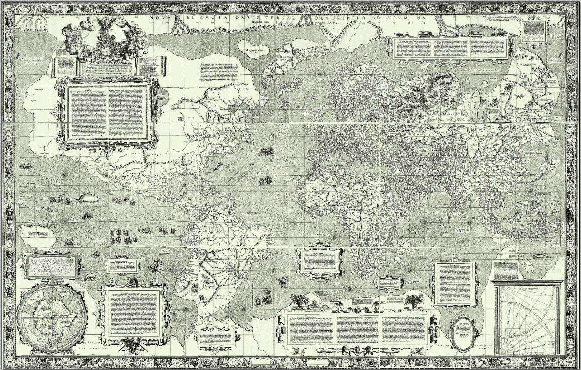
The Mercator 1569 World Map, created by Gerardus Mercator, is one of the most important and influential maps in the history of cartography.
Its design introduced a projection method that revolutionized navigation and map-making.
Background and Creation
- Gerardus Mercator (1512–1594) was a Flemish geographer, cartographer, and mathematician. He was deeply influenced by the age of exploration and the need for accurate maps for maritime navigation.
- The 1569 map, titled Nova et Aucta Orbis Terrae Descriptio ad Usum Navigantium Emendata (A New and Amplified Description of the Earth, Corrected for Use in Navigation), was a large-scale wall map measuring over 2 meters tall and 1.3 meters wide.
- It was composed of 18 separate sheets and covered the known world of the 16th century, combining the most up-to-date geographical knowledge.
The Mercator Projection
The map is most famous for introducing the Mercator projection, a cylindrical map projection that represents lines of constant compass bearing (rhumb lines) as straight segments.
This feature made the map particularly useful for navigation because sailors could chart a straight course between two points using a compass.
Key Features of the Projection
- Latitude and Longitude Grid: The map distorts size and shape, especially near the poles, in order to preserve angles and directions.
- Conformal Property: Angles and shapes of small areas are accurate, but the scale increases dramatically toward the poles.
- Distortion: Greenland and Antarctica appear much larger than their actual size compared to regions near the equator.
Importance and Legacy
- Navigation:
- The Mercator map became an indispensable tool for maritime navigation during the Age of Exploration. Sailors could use it to chart straight-line courses (loxodromes) with ease, a significant advancement over earlier maps.
- Cartographic Innovation:
- The projection method was a groundbreaking innovation in cartography. While it was not the first attempt at such a projection, Mercator’s was the most practical and influential.
- Wider Influence:
- Beyond navigation, the Mercator projection influenced worldviews and education. It was widely used in atlases and textbooks for centuries, shaping how generations perceived the world.
- Criticism and Evolution:
- Over time, the Mercator projection faced criticism for its distortions, particularly for exaggerating the size of Europe and North America relative to Africa and South America. This contributed to Eurocentric perspectives in geography and geopolitics.
- Modern cartographers now use various other projections, such as the Gall-Peters and Robinson projections, to address these issues.
Historical Context
- The map reflects the geographical knowledge of the mid-16th century. It incorporates information from explorers such as Christopher Columbus, Vasco da Gama, and Ferdinand Magellan.
- Some regions, such as the Americas and parts of Asia, are depicted with inaccuracies due to the limited information available at the time.
Legacy
- The Mercator 1569 World Map remains a symbol of the Age of Exploration and a milestone in the history of map-making.
- It is also a key artifact for studying the history of science and technology, illustrating how innovations in mathematics and geography addressed practical challenges of the time.
- Despite its limitations for modern educational use, the Mercator projection continues to be utilized for specific purposes, such as nautical charts and certain online mapping services (e.g., Google Maps).
Preservation and Display
- Original copies of the 1569 map are extremely rare. Most survive in fragments or as reproductions, held in museums and libraries around the world.
- Scholars and cartography enthusiasts study these maps to understand historical perspectives and the evolution of geographic knowledge.
What do you think? Do you think Mercator gets too much hate these days?




Andrew Aitchison says
Can you confirm:
2 meters tall and 1.3 meters wide
– that is portrait, the map shown is landscape ?