Brilliant Maps

Making Sense Of The World, One Map At A Time

  • BOOK!
  • Newsletter
  • Tourist Maps
  • Quizzes
  • Polls
  • Tools

Land vs Water Hemispheres of The Earth

Last Updated: June 25, 2026 1 Comment

Click To Get My 10 Best Brilliant Maps For Free:

Land vs Water Hemispheres of The Earth

Map created by Perrin Remonté

The map above shows the largest possible land and water hemispheres of the earth.

The Land hemisphere is still 53% Water and 47% land, but contains 93% of the world’s population.

The Water hemisphere on the other hand is 89% Water and only 11% land with only 7% of the world’s population.

And here’s a classic version of the same map from 1899:
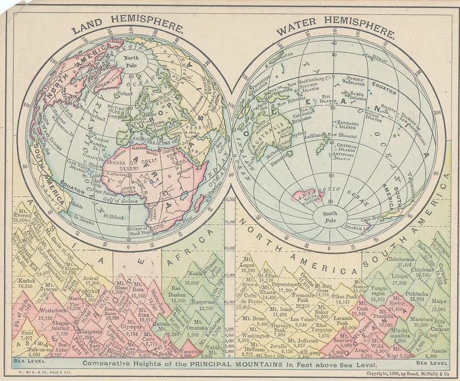
Land and Water Hemispheres by Rand McNally & Co 1899

Map found here

Enjoy this map? Help us by sharing it:

Filed Under: World Maps

Click To Get My 10 Best Brilliant Maps For Free:


Other Popular Maps

  • Most Unique Baby Name In Each State

    Most Unique Baby Name In Each State

  • World Toilet Paper Map Showing Spending On Tissue & Hygiene

    World Toilet Paper Map Showing Spending On Tissue & Hygiene

  • States With The Highest & Lowest Share Of Single Mothers

    States With The Highest & Lowest Share Of Single Mothers

  • When US States Became States Relative To Other Countries

    When US States Became States Relative To Other Countries

  • Timeline Map Of 9/11 Shutdown of North American Airspace

    Timeline Map Of 9/11 Shutdown of North American Airspace

  • Wheat vs Rice Consumption In India By State

    Wheat vs Rice Consumption In India By State

  • The Rapidly Declining Fertility Rate Of India (2001 vs 2021)

    The Rapidly Declining Fertility Rate Of India (2001 vs 2021)

  • Game of Thrones’ Westeros Is Really Just Britain & An Inverted Ireland

    Game of Thrones’ Westeros Is Really Just Britain & An Inverted Ireland

Comments

  1. Jeff Biteen says

    October 7, 2024 at 7:08 pm

    The best place to see the land vs. water hemispheres is at the Maparium in the headquarters of the Christian Science sect in Boston. The room puts you in the interior of a globe of the world (politically circa 1935) with a gangway across the equator. Looking down and taking in a 360-degree view, you realize how little solid ground there is in the southern hemisphere. It’s not as telling as your tilted map, but is still eye-opening.

    Reply

Leave a Reply Cancel reply

Your email address will not be published. Required fields are marked *

This site uses Akismet to reduce spam. Learn how your comment data is processed.


Product Reviews · World Atlas · Map Posters · Settlers of Catan · Risk · Game of Thrones · Coloring Books · Globes · Monopoly · Star Wars · Game of Life · Pandemic · Ticket To Ride · Drinks Cabinets
Size Comparisons · US Locations · Flight Maps · Fleet Management
Copyright © 2026 · Privacy Policy · Fair Use, Attribution & Copyright · Contact Us
Follow Us: Newsletter · Facebook · Youtube · Twitter · Threads · BlueSky · LinkedIn · Instagram · Pinterest · Flipboard