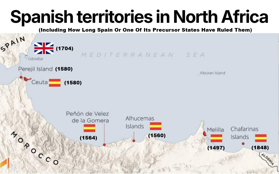
More about each of them below:
| Territory | Best date to use | What happened |
|---|---|---|
| Melilla | 1497 | Spanish forces under Pedro de Estopiñán took Melilla on 17 September 1497. It initially came under the Duke of Medina Sidonia and subsequently passed directly to the Spanish Crown. Spanish military sources treat 1497 as its incorporation into Castile/Spain. |
| Peñón de Vélez de la Gomera | 1564 | Spain first captured the fortress in 1508, but lost it in 1522. Spanish forces recovered it in 1564, and it has remained under Spanish control ever since. |
| Alhucemas Islands | 1560 / 1673 | This one needs two dates. The islands were ceded to the Spanish Crown in 1560 by the Saadi Sultan, reportedly in connection with cooperation against the Ottomans. However, Spain did not actually establish a permanent garrison on Peñón de Alhucemas until 1673. So 1560 = Spanish title; 1673 = continuous physical occupation. |
| Chafarinas Islands | 1848 | Spain occupied the three islands in January 1848, reportedly moving quickly because France, then expanding neighbouring Algeria, was also interested in occupying them. Spain has controlled them since. |
| Ceuta | 1580 or (1668 officially) | Portugal conquered Ceuta in 1415. From 1580, Portugal and Spain shared the same monarch during the Iberian Union, but Portugal remained a separate kingdom. When Portugal restored its independence in 1640, Ceuta remained loyal to the Spanish Habsburg king. Portugal formally recognised/ceded Ceuta to Spain in the Treaty of Lisbon in 1668. So 1580 or 1668 could be argued for when it “became Spanish.” |
| Perejil Island | No clear date | Perejil was historically associated with Portuguese Ceuta, so 1580 marks the beginning of the Iberian Union, but the island's legal history is unusually murky. Both Spain and Morocco claim sovereignty. In 2002 Morocco placed forces on the island, Spain removed them militarily, and a US-mediated agreement restored the previous situation: the island was left unoccupied. |
| Alborán Island (not shown) | 1540 | Alborán lies much farther offshore, roughly between Morocco and Almería. Spanish historiography generally dates Spanish possession from 1540, around the Battle of Alborán. Unlike the tiny possessions immediately off Morocco, it is administratively part of the municipality and province of Almería. |
Today, Ceuta and Melilla are autonomous Spanish cities, with civilian populations and their own local governments.
The much smaller Peñón de Vélez de la Gomera, Alhucemas and Chafarinas are generally referred to as the plazas menores de soberanía and have mainly military rather than civilian populations.
Morocco claims Ceuta, Melilla and several of the smaller territories, while Spain regards them as Spanish territory.
And how does this compare with Gibraltar?
The comparison is fascinating because Spain and Morocco essentially make mirror-image arguments across the Strait.
Gibraltar was captured by an Anglo-Dutch force from Spain in 1704 during the War of the Spanish Succession.
Spain formally ceded Gibraltar to Britain under Article X of the Treaty of Utrecht in 1713, and it remains a British Overseas Territory. Spain nevertheless continues to claim sovereignty over it.
Meanwhile, Morocco argues that Ceuta, Melilla and Spain’s smaller North African possessions should belong to Morocco.
Spain’s basic response is that these territories have been Spanish for centuries, most of them long before the creation of the modern Moroccan state and therefore are not simply remnants of the 19th- and 20th-century Spanish Protectorate.
That produces the striking historical irony:
Spain wants Britain to return Gibraltar, British since 1704/1713, while rejecting Morocco’s demands for territories such as Melilla, Spanish since 1497, and Ceuta, formally Spanish since 1668.
There is also one big difference: Gibraltar was explicitly ceded by Spain to Britain in a surviving international treaty, whereas the historical routes by which Spain obtained its North African territories vary considerably, conquest, cession, inheritance from Portugal and occupation.
And as of July 2026, the new UK–EU Gibraltar agreement has made movement across the Gibraltar–Spain border much easier, but it explicitly does not alter British sovereignty over Gibraltar.




Adam says
This map is a classic example of Spanish colonial propaganda attempting to legitimise occupation by citing dates of conquest as if they confer legal sovereignty, but conquest is not legitimacy, and these dates only mark the beginning of occupation, not the birth of a right. Ceuta, Melilla, and all the Chafarinas Islands, Alhucemas, Peñón de Vélez, and even Perejil are Moroccan territories that were seized by Spain and Portugal at different times, but Morocco never recognised these seizures, never signed any treaty ceding them, and never stopped reclaiming them. The fact that Spain has held them for centuries does not make them Spanish, it makes them occupied, and international law rejects the acquisition of territory by force, regardless of how long ago it occurred. Just as Portugal returned Macau to China after 400 years of occupation because colonisation has no expiration date that transforms it into legitimacy, Spain must do the same with all these enclaves. The map may show dates, but it does not show justice, and justice is on the side of Morocco. All these territories are Moroccan, and their return is not a matter of if, but when.
Alfredo says
Morocco did not exist when Ceuta and Melilla were already part of the Spanish Crown. That part of North Africa was administratively a Roman Diocese of Hispania. Then you could say that African Hispania was occupied by the `political antecessor of Morocco- The Berber Kingdoms: Ancient, indigenous tribal polities (most notably the Kingdom of Mauretania) existed before Marocco occupied those territories. All The region was conquered by the Muslims in the early 8th century. According to your reasoning, The fact that Moroccans have held those territories for centuries does not make them Maroccan, it makes them occupied, and international law rejects the acquisition of territory by force, regardless of how long ago it occurred.
Samuli Glöersen says
The map omits an important question: why did Spain establish these positions?
Spain attempted to suppress Barbary slave-raiding and protect Iberia by occupying strategic North African ports and islands. Capturing Christians for ransom or enslavement was central to the Barbary corsair economy, not an incidental consequence of piracy. Today’s Spanish territories are remnants of that forward-defence system, although Spain never captured all the principal slave-raiding bases or ended the system by itself.
The young United States played a prominent part in its final destruction. During the Barbary Wars of 1801–1805 and 1815, American forces confronted the corsair states. In 1815 Commodore Stephen Decatur compelled Algiers to release captives, end American tribute payments and recognise American navigation rights. The Anglo-Dutch bombardment of Algiers in 1816 subsequently liberated thousands of Christian slaves, while the French conquest of Algiers in 1830 extinguished the system at its principal remaining base.
Adam’s legal argument is also incorrect. The modern prohibition against acquiring territory by force cannot simply be applied retroactively to conquests made in 1415 or 1497. International law applies the principle that territorial title must first be judged according to the law prevailing when it arose. Applying rules created in the twentieth century to every earlier conquest would invalidate much of the world’s present territorial order.
Nor is it true that Morocco “never signed any treaty” recognising Spanish sovereignty or making territorial cessions. In the Spanish–Moroccan Convention of 1859, the Moroccan sovereign recognised Melilla as a Spanish possession, ceded surrounding territory to Spain and undertook to protect Spanish rights at Peñón de Vélez and Alhucemas. Articles 2–7 of the Treaty of Wad Ras of 26 April 1860 expressly confirmed Spanish sovereignty, made further territorial cessions around Ceuta and required the Moroccan authorities to ensure that their subjects respected the Spanish territories. Morocco may contest these arrangements today, but it cannot truthfully claim that they never existed.
The United Nations has not classified Ceuta or Melilla as Non-Self-Governing Territories awaiting decolonisation. Morocco requested their inclusion in 1975, but they were not added. This contrasts with Spanish Sahara, Ifni and Spain’s former equatorial possessions, which the UN did treat as colonial territories.
Macau is therefore not a valid analogy. Portugal and China negotiated a bilateral settlement and jointly declared in 1987 that Macau was Chinese territory under temporary Portuguese administration. Spain has made no comparable declaration concerning Ceuta or Melilla. They are autonomous Spanish cities whose inhabitants are Spanish citizens and participate in Spanish democratic government. Their wishes cannot simply be erased by transferring them to another monarchy in the name of geographical proximity.
Spain’s demand for Gibraltar may expose political inconsistency, but inconsistency does not create Moroccan sovereignty. Gibraltar, Ceuta and Melilla have distinct histories, populations and legal titles.
There is, nevertheless, a modern strategic reversal. After European withdrawal from the surrounding North African territories, Ceuta and Melilla changed from forward defensive positions into exposed pressure points. Morocco can exert leverage through territorial claims, border restrictions and the relaxation of migration controls. In 2021 the European Parliament explicitly condemned Morocco’s use of migration, border control and unaccompanied minors as political pressure against Spain.
The continuity is not ethnic but institutional: individual people are subordinated to political power and used as instruments. Formerly, captives were exploited for ransom and slavery; today, vulnerable migrants—including children—can be placed in danger and used to exert pressure on a neighbouring European state.
Alfredo says
Ceuta, Melilla and other Spanish North African territories became part of the Iberian sphere centuries before the nation-state of Morocco was established.
Ceuta was tied to Hispanic empires long before Arab or Berber dynasties occupied the region. Ceuta has remained under continuous Iberian and Spanish administration since 1668, predating any Moroccan state. The Maghreb was conquered by Muslim forces between 647 and 709 AD.
Motorland says
Fascinating map! What I find especially interesting is how geographically close Europe and Africa are in this part of the world. From Málaga, the Strait of Gibraltar and the northern coast of Africa are surprisingly close — it really puts the unique location of southern Spain into perspective. It makes Andalusia an amazing starting point for exploring both Europe and North Africa.