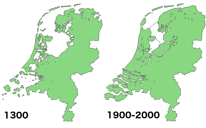
Around 17% of the country’s current land area has been reclaimed from the sea or lakes.
You can see a gif of this process below:

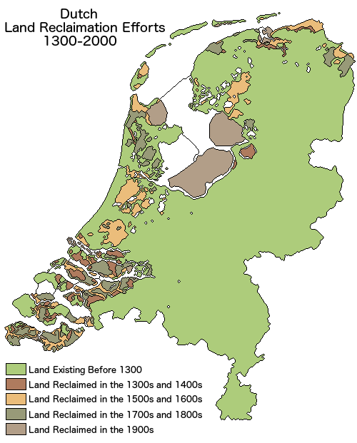
And here’s a map showing during what time period each area was reclaimed:
Here are a few more facts about land area of the Netherlands:
- 26% of its area is located below sea level.
- 21% of its population lives in areas below sea level.
- Only 50% of its area is more than 1 meter above sea level.
- Lowest point: Zuidplaspolder −7 m (−23 ft), below sea level.
- Highest point (In Europe): Vaalserberg 322.7 m (1,059 ft) above sea level.
- Flevoland is the most recent Dutch province and was only created in 1986 on land that was most reclaimed in the 1950s and 1960s.
More on the full-timeline below some more maps:
Netherlands 1300 vs Today Satellite View
Here is another Satellite style map of the what the Netherlands would have looked like in 1300 vs what it does look like today:

Simplified Map of The Netherlands Before & After Building Dams

What The Netherlands Would Look Like If Sea Levels Rise By 2 Meters & The Dams Fail

What The Netherlands would naturally look like if they hadn’t built any dikes to prevent flooding

Road Map Of The Netherlands With & Without Dikes

Land Reclamation Timeline
Here’s a detailed explanation of how the Dutch have achieved all this and thier plans for the future in the face of rising sea levels:
1. Historical Land Reclamation
a. Polder System
- Definition: A polder is a low-lying tract of land enclosed by dikes with its water level artificially managed.
- Process:
- A dike is constructed around the area to be reclaimed.
- Water is drained from the enclosed area using windmills (historically) or modern pumping stations.
- The land is dried and prepared for agriculture or habitation.
- Historical Examples:
- The Beemster Polder (17th century) was one of the first major projects using windmills to drain water.
- The Zuiderzee Works transformed the Zuiderzee (a shallow bay of the North Sea) into the freshwater IJsselmeer and created new polders.
b. Zuiderzee Works
- Purpose: To reduce the risk of flooding and create new land for agriculture.
- Key Features:
- The construction of the Afsluitdijk (Closure Dike) in 1932, which closed off the Zuiderzee from the North Sea, turning it into the IJsselmeer.
- Creation of several large polders, including Flevoland, the largest man-made island in the world.
c. Delta Works
- Reason: Following the devastating North Sea Flood of 1953, which killed over 1,800 people, the Dutch embarked on one of the most ambitious flood control projects in history.
- Key Features:
- A series of dams, sluices, locks, dikes, and storm surge barriers designed to protect the southwestern delta region.
- The Oosterscheldekering (Eastern Scheldt Storm Surge Barrier) is the most famous part, featuring massive movable gates that can be closed during storms.
2. How the Netherlands Prevents Flooding Today
a. Advanced Dike Systems
- Dikes are reinforced and heightened regularly.
- Primary dikes protect against major floods, while secondary dikes provide backup in case the primary ones fail.
b. Pumping Stations
- Modern pumping stations continuously manage water levels in polders and canals, especially during heavy rainfall.
c. Room for the River Project
- Objective: To mitigate flood risks by giving rivers more space to overflow safely during high water levels.
- Measures:
- Lowering floodplains.
- Creating secondary channels.
- Relocating dikes further from rivers.
- Example: In Nijmegen, a new river channel was created to alleviate pressure on the Waal River.
d. Innovative Infrastructure
- The Maeslantkering is a massive storm surge barrier near Rotterdam that can close to protect the city from North Sea storm surges.
- Floating houses and amphibious homes are being developed for flood-prone areas.
3. Addressing Rising Sea Levels in the Future
a. Sea Level Rise Challenges
- Projections estimate a sea-level rise of up to 1.2 meters (4 feet) by 2100, threatening the country’s low-lying areas.
b. Adaptive Delta Management
- The Delta Programme is a long-term plan focused on adapting to climate change and rising sea levels. Key pillars include:
- Flood Risk Management: Strengthening dikes and barriers.
- Freshwater Supply: Ensuring water availability during droughts.
- Spatial Adaptation: Designing cities and infrastructure to handle flooding.
c. Nature-Based Solutions
- Creating natural buffers such as sand dunes and wetlands.
- The Sand Motor project involves depositing large amounts of sand along the coast, allowing natural forces to distribute it and reinforce beaches.
d. Floating Cities and Agriculture
- Designing floating urban areas to adapt to higher water levels.
- Developing salt-tolerant crops and aquaculture to ensure food security.
e. International Collaboration
- Sharing expertise with other flood-prone regions worldwide to innovate and co-develop resilient technologies.
Dike vs Dam what’s the difference?
The terms dike and dam both refer to structures used in water management, but they serve different purposes and have distinct characteristics:
1. Purpose
- Dike:
- A dike is a structure built to prevent water from flooding adjacent land.
- Typically used in areas prone to flooding, such as coastal regions or riverbanks.
- Example: Protecting land from sea-level rise or high river levels.
- Dam:
- A dam is constructed to retain or store water in a reservoir for purposes such as irrigation, hydroelectric power generation, water supply, or recreation.
- Example: Creating a reservoir for drinking water or generating electricity.
2. Placement
- Dike:
- Located along the edge of a body of water (e.g., rivers, seas, or lakes) to keep water out of nearby land areas.
- Usually runs parallel to the water source.
- Dam:
- Built across a river or waterway to block or control the flow of water.
- Often perpendicular to the natural water flow.
3. Functionality
- Dike:
- Does not typically hold back large volumes of water; it redirects or prevents water from spilling into protected areas.
- Relies on its height and structure to withstand flooding pressures.
- Dam:
- Designed to hold back large amounts of water and release it in a controlled manner through outlets or spillways.
- Can manage water flow to prevent downstream flooding.
4. Structure
- Dike:
- Often simpler in design, typically made of earth, stone, or other materials to form a barrier.
- May incorporate drainage systems to handle seepage or overflow.
- Dam:
- More complex engineering, often including spillways, turbines, gates, and reinforced concrete or rock-fill structures.
For more on the Netherlands and Land reclamation have a look at the following books:
- The Dutch and their Delta: Living Below Sea Level
- Beyond Dikes: How the Dutch Work with Water
- Man-made lowlands: History of water management and land reclamation in the Netherlands
Enjoy this map? Please help us by sharing it:


The Map Den says
Love this map of land reclamation and generally loving this web site. Great content, maps and succinct and to the point. Keep up the great work 🙂
Jakki says
Just back from Holland this morning after two weeks holidays. Visited a couple of beautiful historic steam powered pump stations and drove over the IJsselmeer and the Delta Werks dykes. So we saw up close the works. Amazing engineering.
Oliver says
Nice map. However, the Spieringmeer and the Leidsemeer (the two large areas south of Amsterdam) have not been filled in during the 16th century but only much later, in the mid-19th century: Draining the large body of water that by now extended from Haarlem to Leiden only started in 1848. (see e.g. https://en.wikipedia.org/wiki/Haarlemmermeer)
Henk says
The Haarlemmermeer also drew my attention. An area that is missing on the maps is the ´ Middelzee´ in Friesland. Only the northermost part of it is represented on the maps.
Glennert says
I think the third and the fourth color should be switched. All the yellow areas have been reclaimed in the 1800s and 1900s, for example the Haarlemmermeerpolder in 1852 and the Zuidplaspolder in 1840. areas with the fourth color have all been reclaimed in the 1500s and 1600s, for example the Beemster, Schermer and Wijdewormer in 1612, 1635 and 1626 respectively.
George Butiri says
What’s the cost of all of this?
David says
As an alternative: drowning is always free of charge…
James ime Esang says
There is still much reclaimation to be done
Menne Kosian says
there are a lot of mistakes in these maps and texts. Please chack sources and add the sources of the maps. The Cultural Heritage Agency of the Netherlands has a hogue series of historical accurate maps published on it’s website, to be used by anyone who’s interested: https://www.cultureelerfgoed.nl/onderwerpen/bronnen-en-kaarten/overzicht
Land reclamations can be found at https://rce.webgis.nl/nl/map/leven-met-water look for ‘droogmakerijen’
The shape of the land through time can be found at the Heritage Atlas: https://rce.webgis.nl/nl/map/leven-met-water, look for paleogeografie