One of CIA’s oldest and most recognizable intelligence publications, The World Factbook, has sunset. The World Factbook served the Intelligence Community and the general public as a longstanding, one-stop basic reference about countries and communities around the globe.
Link to the History of The World Factbook.
Where is The Dominican Republic? Location Map

List of Land & Sea Borders For Dominican Republic
- United States (Sea): 875 km (544 miles) (via Puerto Rico)
- Haiti (Land + Sea): 376 km (234 miles) land / 497 km (309 miles) sea
- United Kingdom (Sea): 567 km (352 miles) (via the Turks and Caicos Islands)
- Colombia (Sea): 329 km (204 miles)
- Venezuela (Sea): 215 km (134 miles) (via Isla de Aves)
- Netherlands (Sea): 16 km (10.0 miles) (via Saba)
Dominican Republic Facts
Full Official Name: Dominican Republic
Demonym: Dominican
Flag:

Area
Total Area: 48,670 km²
Total Land Area: 48,320 km²
Total Water Area: 350 km²
Demographics
Population: 10,815,857
Population Growth Rate: 0.76% (2024 est.)
Largest City: Santo Domingo (Population: 1,029,110)
Ethnic Groups: mixed 70.4% (Mestizo/Indio 58%, Mulatto 12.4%), Black 15.8%, White 13.5%, other 0.3% (2014 est.)
Languages: Spanish (official)
Religions: Evangelical 50.2%, Roman Catholic 30.1%, none 18.5%, unspecified 1.2% (2023 est.)
Economy
Currency: Dominican peso
Real GDP at Purchasing Power Parity ($ PPP): $261.616 billion (2023 est.)
GDP per capita (PPP): $23,100 (2023 est.)
Exports Value Per Year: $25.843 billion (2023 est.)
Biggest Export Partners: US 50%, Switzerland 8%, Haiti 7%, China 3%, India 3% (2022)
Imports Value Per Year: $34.455 billion (2023 est.)
Biggest Import Partners: US 44%, China 15%, Brazil 4%, Colombia 3%, Spain 3% (2022)
Government
Type: presidential republic
Capital City: Santo Domingo (Population: 1,029,110)
Other Facts
Time Zone: UTC–4 (AST)
Country Code: DO
Internet TLD: .do
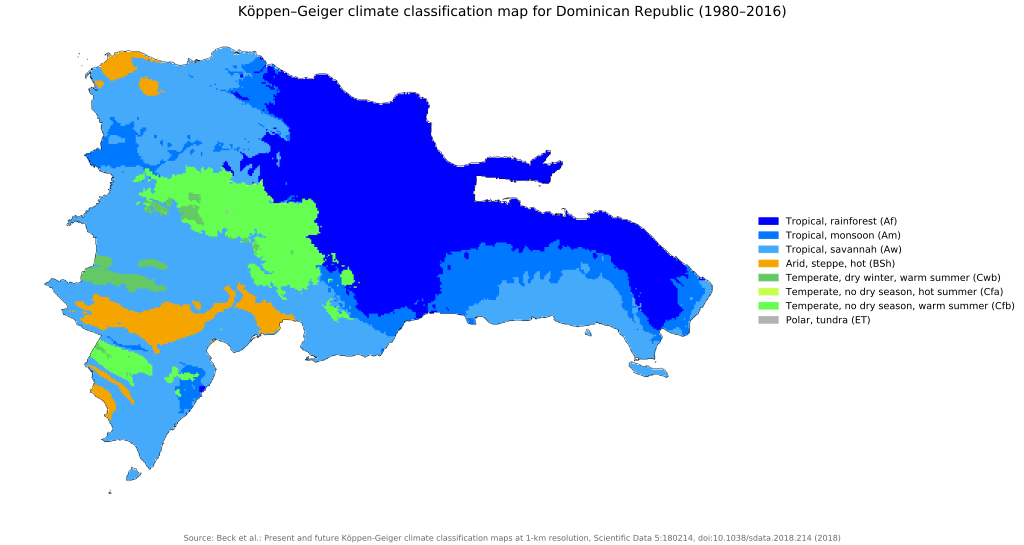
Climate Map of Dominican Republic