Iran Location Map

Iran Facts
Full Official Name: Islamic Republic of Iran
Demonym: Iranian
Flag:

Area
Total Area: 1,648,195 km²
Total Land Area: 1,531,595 km²
Total Water Area: 116,600 km²
Demographics
Population: 88,386,937
Population Growth Rate: 0.88% (2024 est.)
Largest City: Tehran (Population: 9,400,000)
Ethnic Groups: Persian, Azeri, Kurd, Lur, Baloch, Arab, Turkmen, and Turkic tribes
Languages: Persian Farsi (official), Azeri and other Turkic dialects, Kurdish, Gilaki and Mazandarani, Luri, Balochi, Arabic
Religions: Muslim (official) 98.5%, Christian 0.7%, Baha’i 0.3%, agnostic 0.3%, other (includes Zoroastrian, Jewish, Hindu) 0.2% (2020 est.)
Economy
Currency: Iranian rial
Real GDP at Purchasing Power Parity ($ PPP): $1.44 trillion (2023 est.)
GDP per capita (PPP): $16,200 (2023 est.)
Exports Value Per Year: $110.882 billion (2022 est.)
Biggest Export Partners: China 36%, Turkey 20%, Kuwait 6%, Pakistan 5%, India 4% (2022)
Imports Value Per Year: $102.47 billion (2022 est.)
Biggest Import Partners: China 28%, UAE 19%, Brazil 13%, Turkey 9%, India 6% (2022)
Government
Type: theocratic republic
Capital City: Tehran (Population: 9,400,000)
Other Facts
Time Zone: UTC+3:30 (IRST)
Country Code: IR
Internet TLD: .ir
Climate Map of Iran

Topographic Map of Iran

Find Iran On A World Map
From The.World.In.Maps:
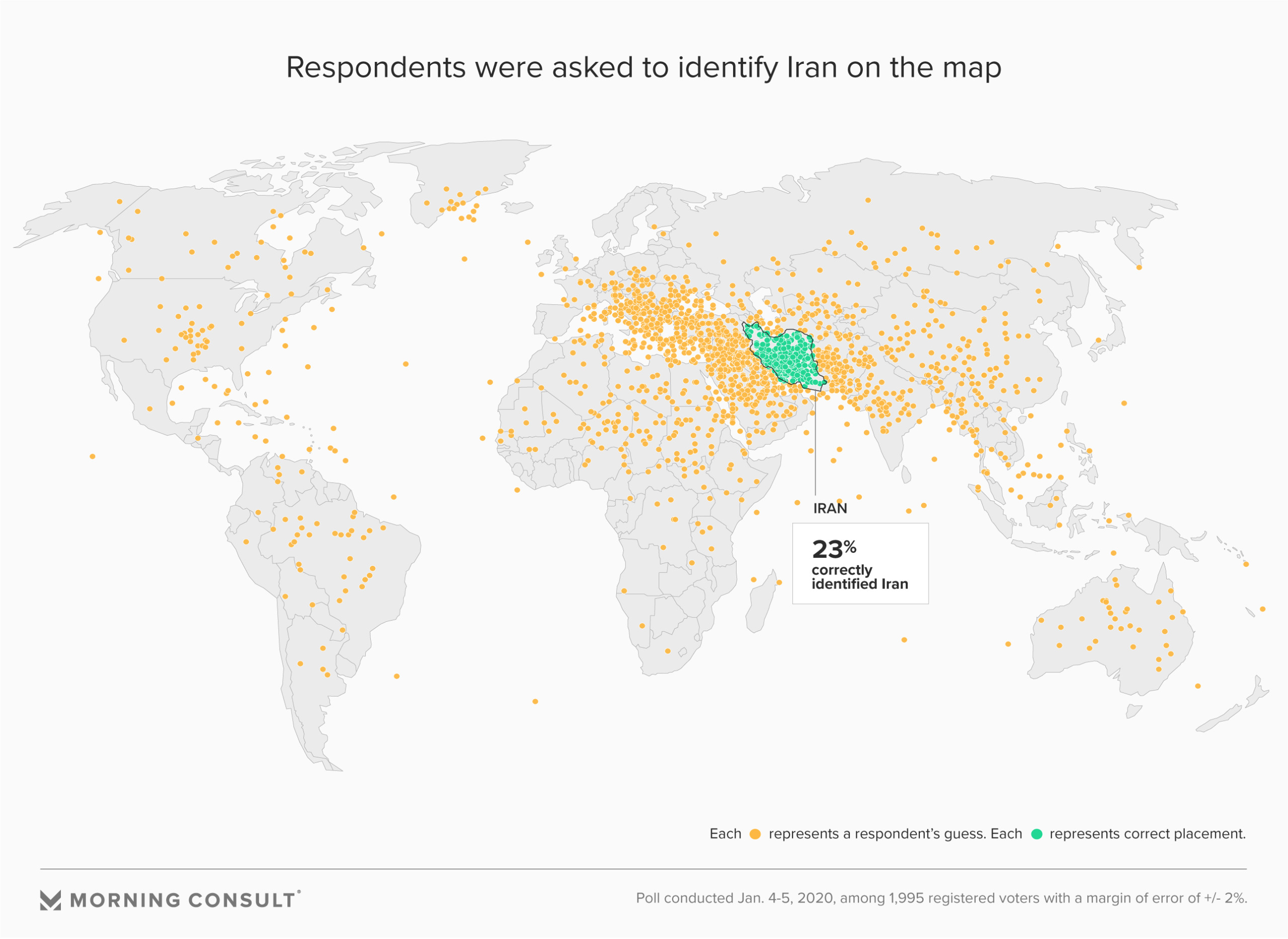
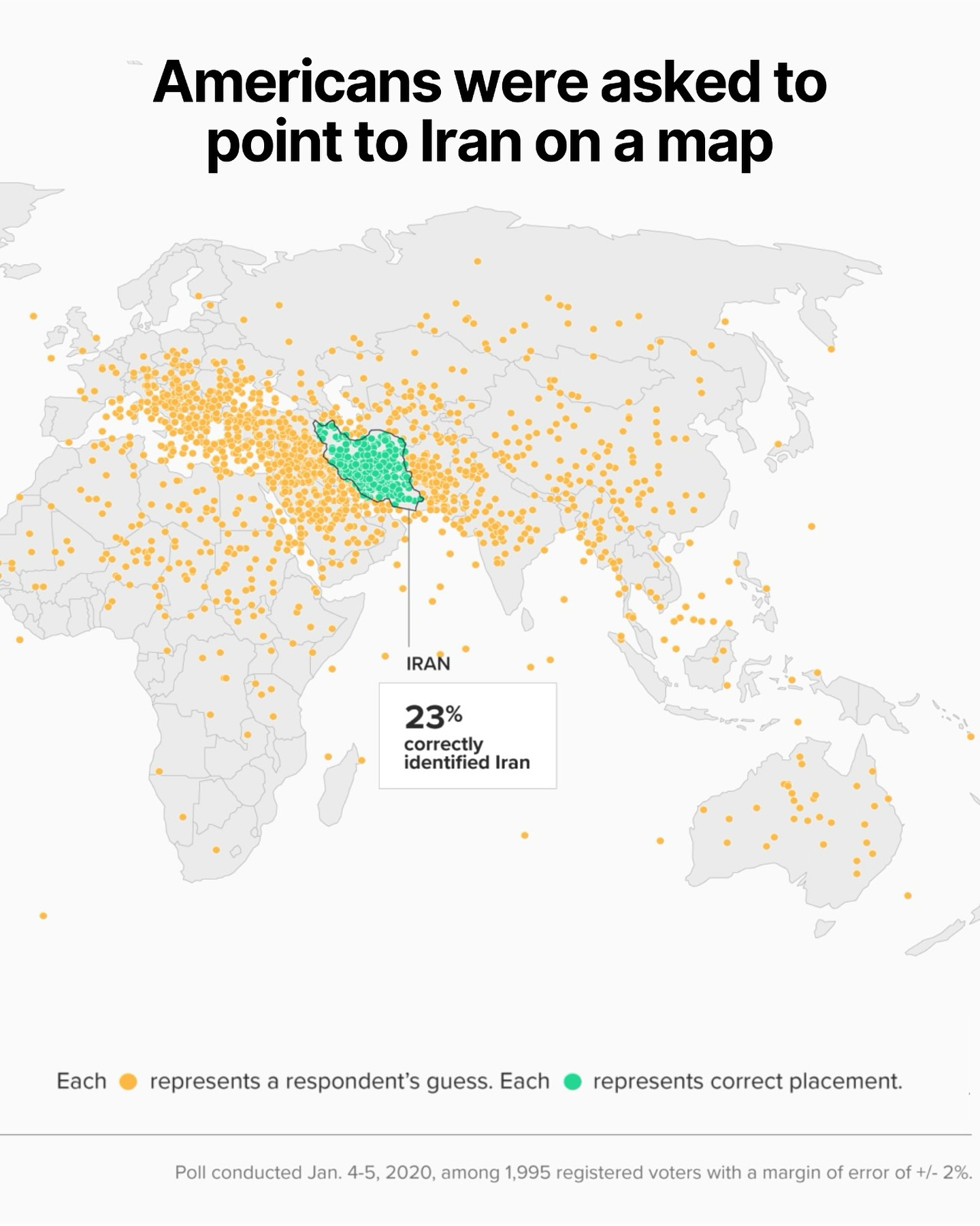
A poll conducted by Morning Consult and Politico revealed a striking fact: only 23% of registered American voters could correctly locate Iran on a blank world map.
Even when shown a zoomed-in map of the Middle East, the number only rose slightly to 28%.
This poll was carried out in early 2020, shortly after the U.S. drone strike that killed Iranian General Qasem Soleimani, an event that pushed Iran into headlines and triggered widespread political debate.
Despite the low levels of geographic knowledge, many Americans expressed strong opinions about U.S. policy toward Iran, including support or opposition to the strike.
This reveals a disconnect between public opinion and basic factual understanding. The poll also found that demographic factors such as education, income level, and gender influenced accuracy: men, wealthier individuals, and those with higher education were more likely to answer correctly. However, factors like age or political affiliation had little effect on performance.
This isn’t the first time such results have appeared.
Similar studies have shown that many Americans struggle to identify key countries involved in major global events, including North Korea, Ukraine, and Afghanistan.
The Iran example underscores a broader issue: when citizens lack basic geographical awareness, it becomes more difficult to have informed public discourse on international affairs.
Ultimately, the poll serves as a reminder of the importance of geographic literacy in a world where global events have immediate political, economic, and human consequences. Knowing where a country is located is a small step, but a vital one toward understanding its context, culture, and the stakes involved in foreign policy decisions.
and finally:
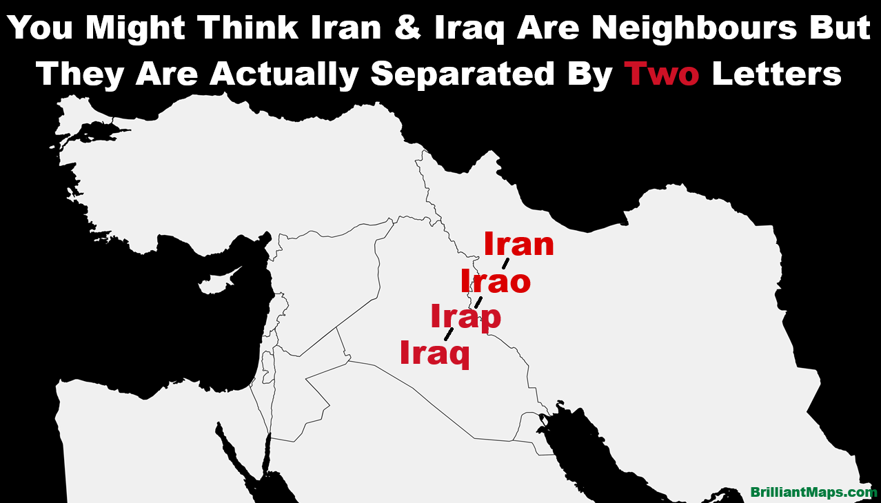
You Might Think Iran & Iraq Are Neighbours But They Are Actually Separated By Two Letters