The term Gulag is an acronym for Гла́вное управле́ние лагере́й (Glavnoye upravleniye lagerey), the “Main Camp Administration”.
While the Soviet system of labour camps goes back to 1918, following the Bolshevik revolution, the Gulag camps reached their peak under Stalin from the 1930’s into the 1950’s.
The population fell briefly during World War 2, both due to starvation and prisoners being released to fight the Nazis, but it’s been estimated that between 2.3 and 50 million people passed through the system at one point during its existence.
While the camps are often seen as being prisons designed for political prisoners, the truth is that they housed a range of prisoners from petty criminals to hardened convicts. Moreover, while they were not explicitly death camps, like those run by the Nazis, they did have significantly higher mortality rates than standard prisons.
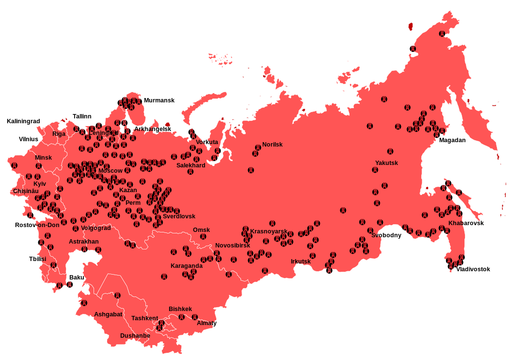
One of the more surprising things revealed in the map above, is that majority of the camps were located in the Western part of the USSR, where the majority of the Soviet Union’s people lived, and not in Siberia. Although, the camps located in Siberia tended to be larger and obviously much harsher due to the climate and environment.
And here is the first map of them in the US titled “Gulag” – Slavery, Inc. The First Comprehensive, Self-authenticated Docu-map of Forced Labor Camps in Soviet Russia

GULAG—the Soviet Slave Labor Trust—is an abbreviation of Glavnaye Upravienye Lagerei, or Office of Penal Labor Camps, a department of the MVD, the Ministry of the Interior (formerly known as the NKVD—Russian equivalent of the Gestapo).
There are over 14,000,000 forced laborers in GULAG, scattered through scores of penal colonies each a Devil’s island at its worst, living in unspeakable wretchedness, on the edge of death by starvation and disease, and driving twelve hours a day under arbitrary taskmasters.
The existence of this state monopoly in expendable human flesh has been known for many years and recognized as a chief source of revenue for the Communist regime.
As far back as 1930, the U.S. Treasury clamped an embargo on Soviet pulpwood and matches as products of “forced labor.” But for the first time, incontrovertible proof of the GULAG system and its vast ramifications has been brought out of Russia.
During the period of the Stalin-Hitler Pact, about 1,600,000 Poles—men, women and children—were deported by the Soviet authorities to GULAG colonies in the far North and in Siberia.
On August 12, 1941, as a result of the Polish-Soviet Agreement, an amnesty was granted to the Polish internees in Russia. 114,000 of these released Poles eventually reached Iran, forming the backbone of the Polish Army which fought bravely.
Legend
The dotted circles represent GULAG forced labor colonies, each a sprawling area comprising a concentration of camps under a separate administration.
The ringed dots denote individual concentration camps operated by municipalities under the control of local NKVD authorities.
PENAL LABOR COLONIES, BY ADMINISTRATIVE AREAS
The following list details the types of industries operated by GULAG—the Penal Labor Trust of the Soviet Government. Although complete on the basis of available documentary evidence, the forty-odd colonies shown here do not exhaust all the geographic divisions of GULAG known to exist in the Soviet Union.
(Several locations and activities listed here, summarized below:)
- Sorok administration: Metal industry, railway construction, lumber.
- Kargopol, Severo-Dvina, Kotlas, Vytegra, Ust-Vym: Road construction, forestry, agriculture.
- Northern Railway Camps: Railway maintenance.
- Volgolag, Ukhta, Pechora, etc.: Railways, oil, coal, lumber.
- Karaganda, Balkhash, Samarkand, etc.: Mining, road-building.
- Kolyma: Gold mining, road-building.
- Vorkuta: Coal mining, metallurgy.
- Norilsk, Dudinka: Metal mining, metallurgy, Arctic projects.
SOURCES
Nearly 14,000 affidavits, plus other documentary evidence and crude maps made by ex-inmates of Soviet prisons and concentration camps, served as the source material for this Docu-Map.
All of these came from liberated inmates, many of whom supplemented their affidavits with detailed statements of their experiences as Soviet captives.
Photostatic reproductions of the official “passports” furnished to the amnestied men and women by the various GULAG administrations bearing the seals and signatures of camp commanders have been reproduced here to furnish graphic proof of the number and magnitude of Slavery, Inc. as operated by the Soviet Government.
ON THE BASIS OF THE MASS of documentary evidence gathered from the amnestied deportees, it has been established that the average mortality rate in GULAG exceeds 12% a year.
In other words, every eight years its total population perishes. It is, of course, being constantly replenished, so that Slavery, Inc. is never short of manpower—Russia’s cheapest commodity.
GULAG’s human reservoir is a cross-section of Soviet society. It ranges from recalcitrant peasants and workers to Red Army generals in disgrace, and includes the intellectual classes and the industrial bureaucracy. Grimly ironic is the fact that GULAG has been the final home for thousands of Communist expatriates who took refuge in the land of their dreams only to end up in slave labor colonies.
Since the end of the war, some 2,000,000 Japanese war prisoners, about 1,000,000 German war prisoners, and not less than 2,000,000 repatriated Russian war prisoners, treated as deserters with whom they are lumped, have been added to GULAG’s rolls.
Most of the Japanese prisoners are engaged in a great project: building secretly a railroad through northeastern Siberia, not indicated in the Docu-Map.
The boundaries of the slave labor regions have been drawn here with a view to understatement. All territory controlled by GULAG, if consolidated, would make a submerged empire exceeding in area the boundaries of Western Europe.
Copyright, 1947, PLAIN TALK, Inc. 240 Madison Ave., New York 16, N.Y.
A Reward of $1,000 Will Be Paid by PLAIN TALK for Evidence Disproving the Authenticity of the Soviet Documents Here Reproduced.
If you’d like to learn more, we highly recommend the following books:
- The Gulag Archipelago
- Gulag: A History
- The Unknown Gulag: The Lost World of Stalin’s Special Settlements
Find this post interesting? Please help us by sharing it:


Lee D. Cary says
How do I order a large map of the Gulag system?
Pamela J. Jacobs says
I am looking for location of Camp 303, about 200-300 miles southwest of Yakutsk, north side of Lena river. Thank you.
Rod Hartman says
Is there a map and location of the Sewzieldorlag Gulag or Sevzheldorlag Gulag. I am hoping someone can lead me in the right direction.