The map above shows Maine and Victoria side by side at exactly the same scale, using equal-area projections, so their true relative sizes are preserved.
Maine vs Victoria Geography
Land area
- Maine has a land area of 30,845 square miles (79,888 km²), while Victoria has 87,806 square miles (227,416 km²).
- Victoria's land area is 2.8 times (185%) larger than Maine's.
Total area
- Maine: 35,380 square miles (91,634 km²) vs Victoria: 87,806 square miles (227,416 km²), including inland and coastal water.
- Victoria's total area is 2.5 times (148%) larger than Maine's.
Length
- Maine is 311 miles (501 km) long from north to south; Victoria is 466 miles (751 km).
- Victoria's north-south length is 1.5 times (50%) longer than Maine's.
Width
- Maine spans 203 miles (327 km) east to west; Victoria spans 558 miles (897 km).
- Victoria's east-west width is 2.7 times (175%) wider than Maine's.
Highest point
- Maine's highest point is Mount Katahdin at 5,253 feet (1,601 m); Victoria's is Mount Bogong at 6,516 feet (1,986 m).
- Mount Bogong is 1,263 feet higher than Mount Katahdin.
Lowest point
- Maine's lowest point is Atlantic Ocean at 0 feet; Victoria's is Southern Ocean at 0 feet.
- Both lowest points are at or near sea level.
Maine vs Victoria Population and History
Population
- Maine has a population of 1,405,012 (2024), while Victoria has 7,104,349 (2025).
- Victoria's population is 5.1 times (406%) larger than Maine's.
Population density
- Maine: 45.6 people per square mile vs Victoria: 80.9.
- Victoria's population density is 1.8 times (77%) higher than Maine's.
Largest metro area
- Maine's largest metropolitan area is Portland-South Portland, ME metro area (571,534 people) vs Victoria's Greater Melbourne (5,435,590).
- Greater Melbourne's population is 9.5 times (851%) larger than Portland-South Portland, ME metro area's.
History
- Maine: Admitted to the Union on March 15, 1820, as the 23rd state.
- Victoria: Became an Australian state at Federation on January 1, 1901; separated from New South Wales in 1851.
- In its current form, Maine is the older of the two by 81 years.
Maine vs Victoria Economy
GDP
- Maine's GDP is $99.2 billion (2024) vs Victoria's $406.1 billion.
- Victoria's economic output is 4.1 times (309%) larger than Maine's.
GDP per capita
- Maine: $70,586 per person vs Victoria: $57,162.
- Maine's GDP per capita is 1.2 times (23%) higher than Victoria's.
Official Websites
Maine official website · Victoria official website
Download the Maine vs Victoria Size Comparison Map for free
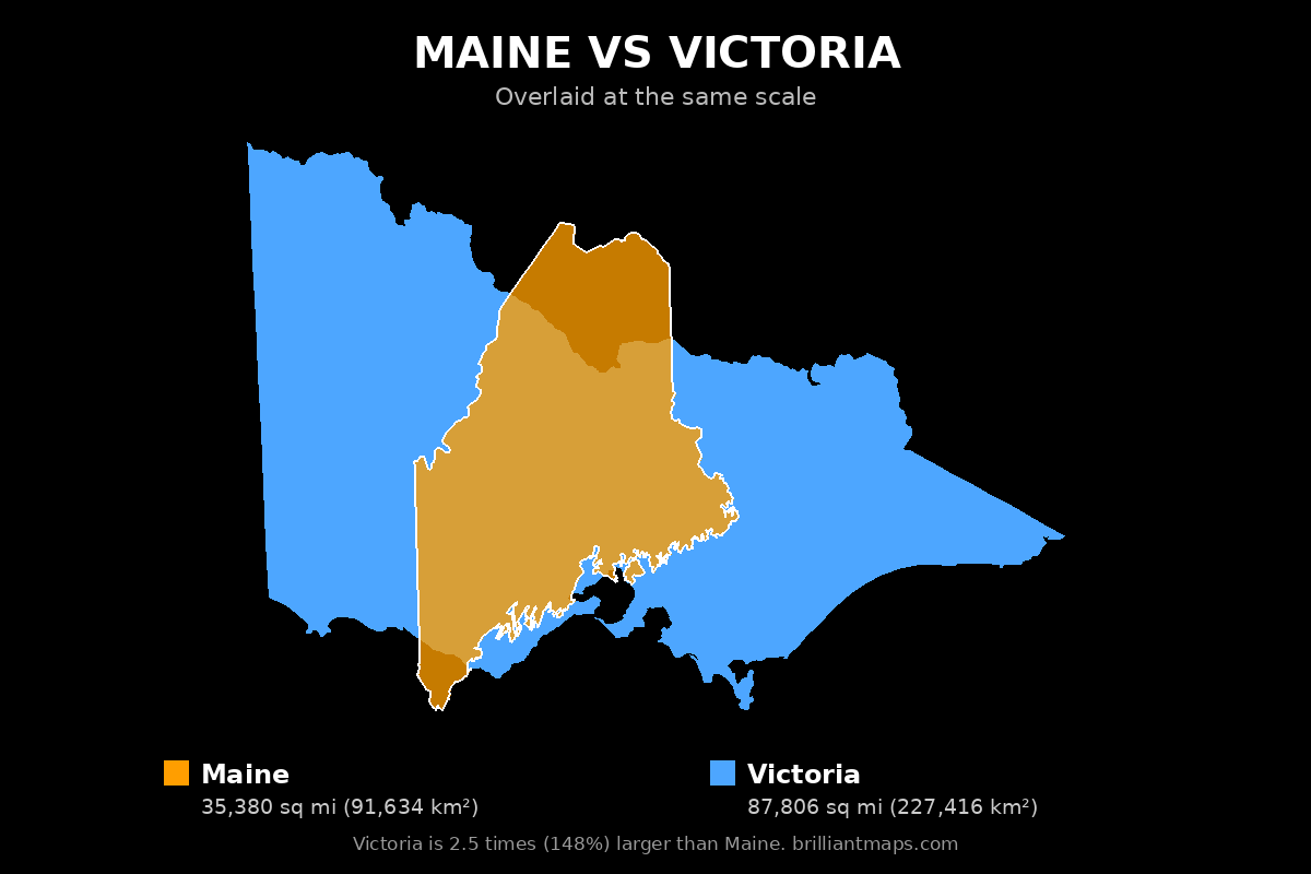
To download the map, right-click the image above (or press and hold on a phone or tablet) and choose Save image as. The map is free to use anywhere, including on your own website or in print, as long as you credit it with a link back to this page or to BrilliantMaps.com.
More Size Comparisons
All Maine size comparisons · All Victoria size comparisons
Area, elevation and boundary figures come from official national statistics and US Census Bureau and Natural Earth boundary data; US state population, economic, county and tax figures come from the US Census Bureau, the Bureau of Economic Analysis and the Tax Foundation. Figures are rounded and for general reference.