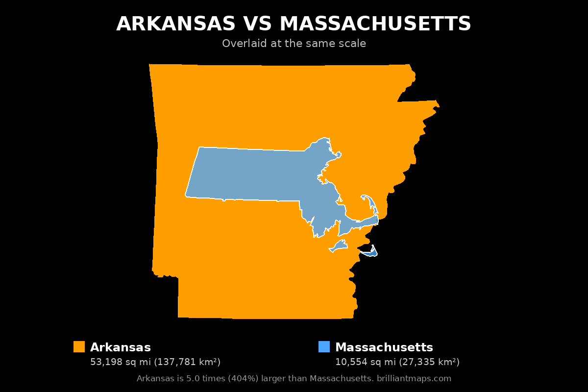
The map above shows Arkansas and Massachusetts side by side at exactly the same scale, using equal-area projections, so their true relative sizes are preserved.
Arkansas vs Massachusetts Geography
Land area
- Arkansas has a land area of 51,992 square miles (134,658 km²), while Massachusetts has 7,801 square miles (20,204 km²).
- Arkansas' land area is 6.7 times (566%) larger than Massachusetts'.
Total area
- Arkansas: 53,198 square miles (137,781 km²) vs Massachusetts: 10,554 square miles (27,335 km²), including inland and coastal water.
- Arkansas' total area is 5.0 times (404%) larger than Massachusetts'.
Length
- Arkansas is 243 miles (392 km) long from north to south; Massachusetts is 123 miles (198 km).
- Arkansas' north-south length is 2.0 times (98%) longer than Massachusetts'.
Width
- Arkansas spans 279 miles (449 km) east to west; Massachusetts spans 185 miles (297 km).
- Arkansas' east-west width is 1.5 times (51%) wider than Massachusetts'.
Highest point
- Arkansas's highest point is Mount Magazine at 2,752 feet (839 m); Massachusetts's is Mount Greylock at 3,489 feet (1,063 m).
- Mount Greylock is 737 feet higher than Mount Magazine.
Lowest point
- Arkansas's lowest point is Ouachita River at 55 feet; Massachusetts's is Atlantic Ocean at 0 feet.
- Massachusetts's lowest point is 55 feet lower.
Arkansas vs Massachusetts Population and History
Population
- Arkansas has a population of 3,088,354 (2024), while Massachusetts has 7,136,171 (2024).
- Massachusetts' population is 2.3 times (131%) larger than Arkansas'.
Population density
- Arkansas: 59.4 people per square mile vs Massachusetts: 914.8.
- Massachusetts' population density is 15.4 times higher than Arkansas'.
Biggest city
- Arkansas's biggest city is Little Rock with 204,774 people; Massachusetts's is Boston with 673,458.
- Boston's population is 3.3 times (229%) larger than Little Rock's.
Largest metro area
- Arkansas's largest metropolitan area is Memphis, TN-MS-AR metro area (1,339,345 people) vs Massachusetts's Boston-Cambridge-Newton, MA-NH metro area (5,025,517).
- Boston-Cambridge-Newton, MA-NH metro area's population is 3.8 times (275%) larger than Memphis, TN-MS-AR metro area's.
History
- Arkansas: Admitted to the Union on June 15, 1836, as the 25th state.
- Massachusetts: Admitted to the Union on February 6, 1788, as the 6th state.
- In its current form, Massachusetts is the older of the two by 48 years.
Arkansas vs Massachusetts Economy
GDP
- Arkansas's GDP is $188.3 billion (2024) vs Massachusetts's $778.5 billion.
- Massachusetts' economic output is 4.1 times (313%) larger than Arkansas'.
GDP per capita
- Arkansas: $60,984 per person vs Massachusetts: $109,095.
- Massachusetts' GDP per capita is 1.8 times (79%) higher than Arkansas'.
Average income
- Arkansas: $59,320 vs Massachusetts: $93,607 average income per person (per capita personal income).
- Massachusetts' average income is 1.6 times (58%) higher than Arkansas'.
Arkansas vs Massachusetts Counties
Number of counties
- Arkansas has 75 counties, while Massachusetts has 14.
- Arkansas' county count is 5.4 times (436%) higher than Massachusetts'.
Biggest county by area
- Arkansas's largest county is Union County at 1,039 square miles; Massachusetts's is Worcester County at 1,511 square miles.
- Worcester County's land area is 1.5 times (45%) larger than Union County's.
Smallest county by area
- Arkansas: Lafayette County (530 sq mi) vs Massachusetts: Nantucket County (46 sq mi).
- Lafayette County's land area is 11.5 times larger than Nantucket County's.
Most populous county
- Arkansas: Pulaski County (401,209 people) vs Massachusetts: Middlesex County (1,668,956 people).
- Middlesex County's population is 4.2 times (316%) larger than Pulaski County's.
Least populous county
- Arkansas: Calhoun County (4,690 people) vs Massachusetts: Nantucket County (14,670 people).
- Nantucket County's population is 3.1 times (213%) larger than Calhoun County's.
Richest county
- Arkansas: Benton County ($120,594 per capita income) vs Massachusetts: Nantucket County ($129,250).
- Nantucket County's income is 1.1 times (7%) richer than Benton County's.
Poorest county
- Arkansas: Lincoln County ($36,032 per capita income) vs Massachusetts: Hampshire County ($65,432).
- Hampshire County's income is 1.8 times (82%) richer than Lincoln County's.
Arkansas vs Massachusetts Taxes
State income tax
- Arkansas has a top income tax rate of 3.9%, while Massachusetts has a top income tax rate of 9%.
- Massachusetts's top rate is 5.1 percentage points higher.
Property tax
- Arkansas: 0.52% effective rate vs Massachusetts: 1% of home value per year.
- Massachusetts's rate is 0.48 percentage points higher.
Sales tax
- Arkansas: 9.48% combined state and average local rate vs Massachusetts: 6.25%.
- Arkansas's combined rate is 3.23 percentage points higher.
Official Websites
Arkansas official website · Massachusetts official website
Download the Arkansas vs Massachusetts Size Comparison Map for free
To download the map, right-click the image above (or press and hold on a phone or tablet) and choose Save image as. The map is free to use anywhere, including on your own website or in print, as long as you credit it with a link back to this page or to BrilliantMaps.com.
More Size Comparisons
All Arkansas size comparisons · All Massachusetts size comparisons
Area, elevation and boundary figures come from official national statistics and US Census Bureau and Natural Earth boundary data; US state population, economic, county and tax figures come from the US Census Bureau, the Bureau of Economic Analysis and the Tax Foundation. Figures are rounded and for general reference.