Brilliant Maps

Making Sense Of The World, One Map At A Time

  • BOOK!
  • Newsletter
  • Tourist Maps
  • Quizzes
  • Polls
  • Tools

Interactive Yorke Peninsula Tourist Map: Find The 14 Best Things To Do

Last Updated: November 11, 2026

Click To Get My 10 Best Brilliant Maps For Free:

The Yorke Peninsula is a boot-shaped peninsula in South Australia between Spencer Gulf and Gulf St Vincent, about two hours from Adelaide, a farming region with Cornish mining heritage in the Copper Triangle and surf and fishing coasts. Explore Dhilba Guuranda-Innes National Park and the ghost town of Inneston, see the wreck of the Ethel, visit Corny Point Lighthouse, swim in the Edithburgh tidal pool and tour the Moonta Mines.

MoontaArdrossanMaitlandMinlatonYorketownPort VincentStansburyPoint TurtonWarookaCorny PointHardwicke BayPort Moorowie6. Clinton Conservation Park6ClintonConservation Park3. Balgowan3Balgowan1. Maitland1Maitland2. Point Pearce2Point Pearce5. South Kilkerran5South Kilkerran9. Goose Island Conservation Park9Goose IslandConservation Park10. Wardang Island10Wardang Island8. Corny Point Lighthouse8Corny Point Lighthouse14. Leven Beach Conservation Park14Leven BeachConservation Park11. Troubridge Island11Troubridge Island13. Point Davenport Conservation Park13Point DavenportConservation Park12. Troubridge Hill Lighthouse12TroubridgeHill Lighthouse4. Dhilba Guuranda–Innes National Park4Dhilba Guuranda–InnesNational Park7. Althorpe Islands Conservation Park7Althorpe IslandsConservation Park
Tap a picture for details or zoom in to explore.
Map data © OpenStreetMap, Natural Earth

List of all 14 things to do in Yorke Peninsula and where to find them

  1. Maitland Wikipedia
  2. Point Pearce Wikipedia
  3. Balgowan Wikipedia
  4. Dhilba Guuranda–Innes National Park Website Wikipedia
  5. South Kilkerran Wikipedia
  6. Clinton Conservation Park Wikipedia
  7. Althorpe Islands Conservation Park Wikipedia
  8. Corny Point Lighthouse Wikipedia
  9. Goose Island Conservation Park Wikipedia
  10. Wardang Island Wikipedia
  11. Troubridge Island Wikipedia
  12. Troubridge Hill Lighthouse Wikipedia
  13. Point Davenport Conservation Park Wikipedia
  14. Leven Beach Conservation Park Wikipedia

Official websites and travel guides

  • Yorke Peninsula travel guide: Wikivoyage
  • Yorke Peninsula on Wikipedia
  • All Yorke Peninsula tours and activities on Viator

Where To Stay In Yorke Peninsula: Interactive Yorke Peninsula Hotel Map

Marion Bay is the closest base to Innes National Park; Port Vincent and Edithburgh suit the sheltered east coast, and Moonta or Wallaroo are the main towns of the Copper Coast in the north. Compare hotels on the map below.

Top Things To Do In Yorke Peninsula Today

Download The Illustrated Yorke Peninsula Tourist Map
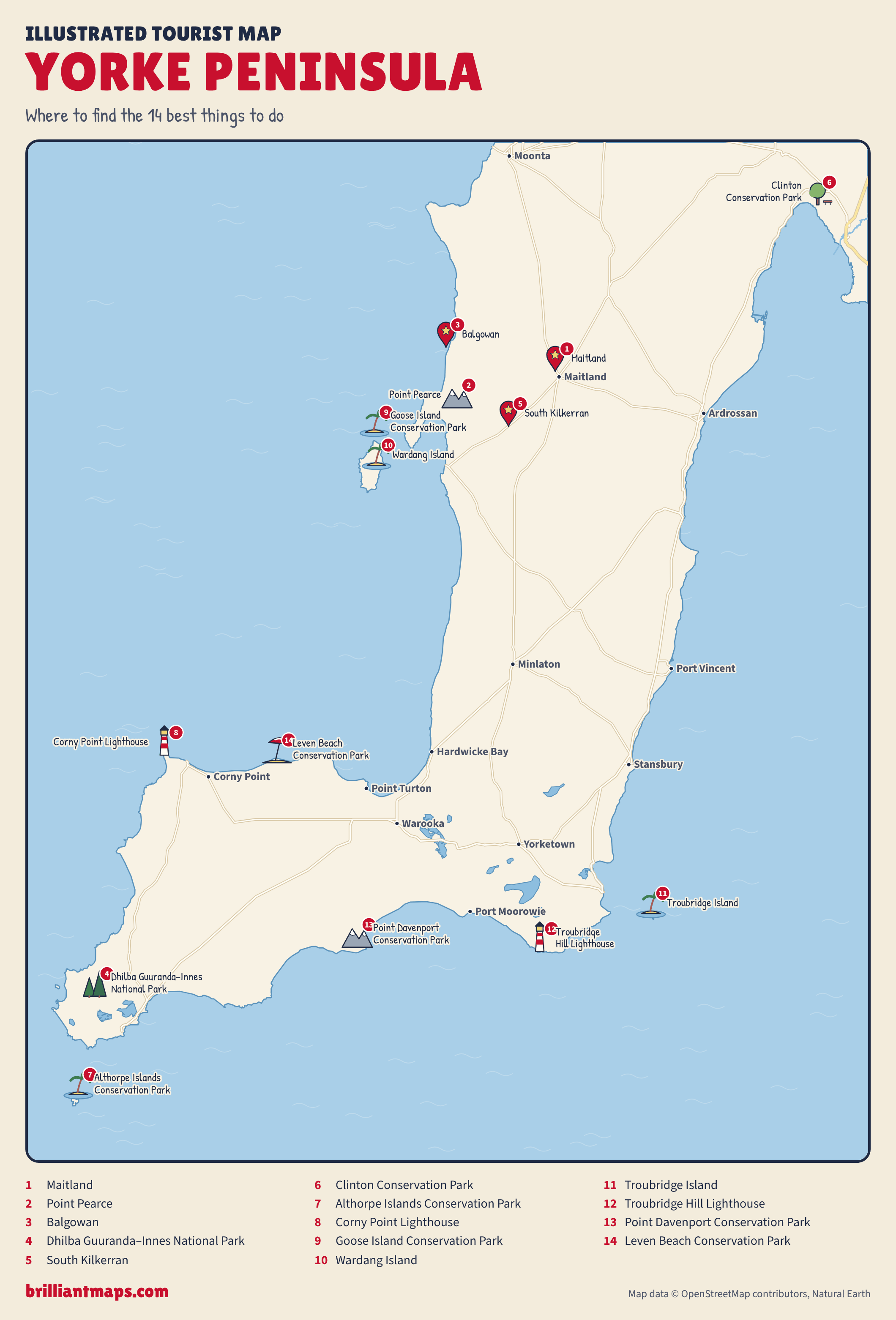
Illustrated Yorke Peninsula Tourist Map: Where To Find The 14 Best Things To Do

Download the Yorke Peninsula map (PNG)

More Tourist Maps Near Yorke Peninsula

Yorke Peninsula is part of:

  • South Australia Tourist Map
  • Australia Tourist Map


Product Reviews · World Atlas · Map Posters · Settlers of Catan · Risk · Game of Thrones · Coloring Books · Globes · Monopoly · Star Wars · Game of Life · Pandemic · Ticket To Ride · Drinks Cabinets
Size Comparisons · US Locations · Flight Maps · Fleet Management
Copyright © 2026 · Privacy Policy · Fair Use, Attribution & Copyright · Contact Us
Follow Us: Newsletter · Facebook · Youtube · Twitter · Threads · BlueSky · LinkedIn · Instagram · Pinterest · Flipboard