The Cotswolds is an area of rolling hills and honey-coloured stone villages in central England. Visit Crickley Hill for sweeping views, see the medieval churches of Duntisbourne Rouse and Bagendon and explore the village of Miserden.
Tap a picture for details or zoom in to explore.
Map data © OpenStreetMap, Natural Earth
List of all 33 things to do in Cotswolds and where to find them
- St Michael's Church, Duntisbourne RouseWelsh Way, Cotswold District, GL7 7AR Wikipedia
- Miserden CastleMMN35, Stroud, GL6 7JA Wikipedia
- Crickley Hill and Barrow WakeA417, Tewkesbury, GL4 8JY Wikipedia
- Five Mile House, Duntisbourne AbbotsGloucester Road, Duntisbourne Abbots, Cirencester, Gloucestershire, GL7 7JR Wikipedia
- Miserden War MemorialMiserden Park Lane, Stroud, GL6 7JA Wikipedia
- Church of St Margaret, BagendonWelsh Way, Cotswold District, GL7 7BW Wikipedia
- Church of the Holy Rood, DaglingworthCirencester Road, Cotswold District, GL7 7AQ Wikipedia
- Church of St Mary, EdgeworthSchool Lane, Cotswold District, GL6 7JH Wikipedia
- Church of St John the Evangelist, ElkstoneCockleford Road, Cheltenham, GL53 9PD Wikipedia
- Church of St Peter, RendcombCheltenham Road, Cotswold District, GL7 7BY Wikipedia
- Church of St Mary the Virgin, SydeSalt Way, Cheltenham, GL53 9PN Wikipedia
- Church of St Bartholomew, WinstoneCroft Lane, Cotswold District, GL7 7JU Wikipedia
- Church of St Michael, WithingtonMill Lane, Cotswold District, GL54 4BN Wikipedia
- Bagendon hillfortCutham Lane, Cotswold District, GL7 7DY Wikipedia
- Workmans Wood, Sheepscombe Wikipedia
- St Peter's Church, LeckhamptonChurch Road, Cheltenham, GL53 0QJ Website Wikipedia
- Devil's Chimney (Gloucestershire)Dead Man's Incline, Tewkesbury, GL53 9QH Wikipedia
- Chedworth Roman VillaChedworth Nature Reserve, Cotswold District, GL54 3LJ Website Wikipedia
- Great Witcombe Roman VillaWitcombe Roman Villa, Tewkesbury, GL3 4TW Website Wikipedia
- Barnsley Warren Wikipedia
- Dowdeswell ReservoirA40, Cotswold District, GL54 4HG Wikipedia
- St Mary's Church, Shipton SolarsA40, Cheltenham, GL54 4HU Website Wikipedia
- Daneway Banks SSSI Wikipedia
- Cotswold Commons and BeechwoodsMain Street, Stroud, GL4 8HR Wikipedia
- Leckhampton Hill and Charlton Kings CommonDaisybank Road, Cheltenham, GL53 9QQ Wikipedia
- Lineover WoodGloucester Road, Cotswold District, GL54 4LS Wikipedia
- Chedworth Nature ReserveChedworth Nature Reserve, Cotswold District, GL54 3LJ Wikipedia
- Siccaridge Wood Wikipedia
- Sapperton Valley Wikipedia
- St Kenelm's Church, Sapperton, GloucestershireChurch Lane, Cotswold District, GL7 6LG Wikipedia
- Church of St Andrew, ChedworthChurch Row, Cheltenham, GL54 4AD Wikipedia
- Church of St Oswald, Shipton OliffeSchool Lane, Cotswold District, GL54 4JB Wikipedia
- Alfred's HallDaglingworth Path, Cotswold District, GL7 6LT Wikipedia
Official websites and travel guides
- Official Cotswolds tourism website: www.cotswolds.com
- Cotswolds travel guide: Wikivoyage
- Cotswolds on Wikipedia
- All Cotswolds tours and activities on Viator
Where To Stay In Cotswolds: Interactive Cotswolds Hotel Map
Cirencester suits travellers wanting a market town base. Bourton-on-the-Water and Stow-on-the-Wold offer classic Cotswold villages, while Cheltenham suits those wanting a larger town with shops and restaurants. See the map below.
Top Things To Do In Cotswolds Today
Download The Illustrated Cotswolds Tourist Map
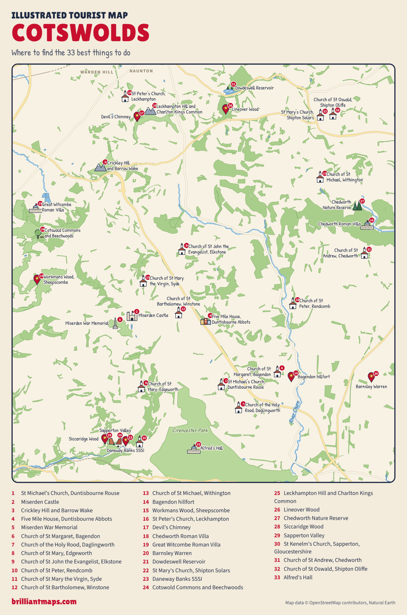
Download the Cotswolds map (PNG)
More Tourist Maps Near Cotswolds
Cotswolds is part of: