One of CIA’s oldest and most recognizable intelligence publications, The World Factbook, has sunset. The World Factbook served the Intelligence Community and the general public as a longstanding, one-stop basic reference about countries and communities around the globe.
Link to the History of The World Factbook.
Where are The Falkland Islands (Islas Malvinas)? Location Map

Falkland Islands (Islas Malvinas) Borders
- Argentina (sea): 1,272 km (790 miles)
- Coastline: 1,288 km (800 miles)
Falkland Islands (Islas Malvinas) Facts
Full Official Name: Falkland Islands
Demonym: Falkland Islander, Falklander
Flag:

Area
Total Area: 12,173 km²
Total Land Area: 12,173 km²
Total Water Area: 0 km²
Demographics
Population: 3,662
Population Growth Rate: 0.01% (2014 est.)
Largest City: Stanley (Population: 2,460)
Ethnic Groups: Falkland Islander 48.3%, British 23.1%, St. Helenian 7.5%, Chilean 4.6%, mixed 6%, other 8.5%, unspecified 2% (2016 est.)
Languages: English 89%, Spanish 7.7%, other 3.3% (2006 est.)
Religions: Christian 57.1%, other 1.6%, none 35.4%, unspecified 6% (2016 est.)
Economy
Currency: Pound sterling, Falkland Islands pound
Real GDP at Purchasing Power Parity ($ PPP): $206.4 million (2015 est.)
GDP per capita (PPP): $70,800 (2015 est.)
Exports Value Per Year: $257.3 million (2015 est.)
Biggest Export Partners: Spain 70%, Morocco 9%, US 8%, Namibia 5%, Germany 2% (2022)
Imports Value Per Year: N/A
Biggest Import Partners: UK 73%, Spain 24%, Netherlands 1%, Ireland 0%, Switzerland 0% (2022)
Government
Type: parliamentary democracy (Legislative Assembly); self-governing overseas territory of the UK
Capital City: Stanley (Population: 2,460)
Other Facts
Time Zone: UTC– 03:00 (FKST)
Country Code: FK
Internet TLD: .fk
Climate: cold marine; strong westerly winds, cloudy, humid; rain occurs on more than half of days in year; average annual rainfall is 60 cm in Stanley; occasional snow all year, except in January and February, but typically does not accumulate
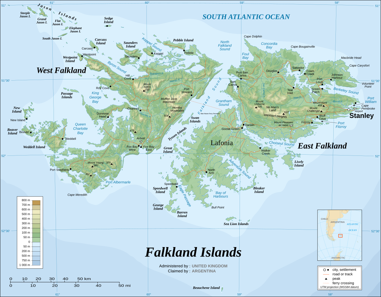
Topographic Map of Falkland Islands (Islas Malvinas)