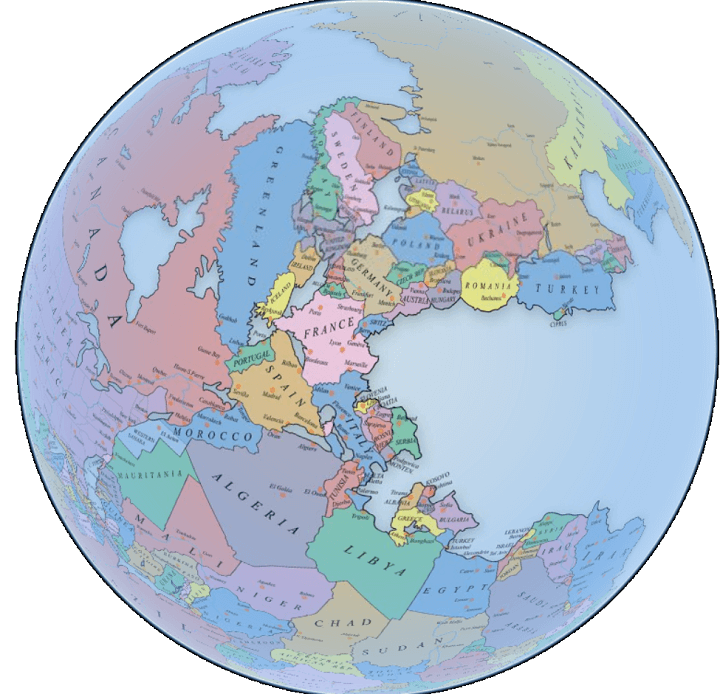
One of our most popular maps is Pangaea With Current International Borders.
However, while it’s without a doubt an amazing map, many users have commented that they wished that you could see the whole world.
Fortunately, Massimo Pietrobon via Tomas Slavkovsky from Melown, has done just that, creating a fully interactive Pangaea map with modern international borders that allows you to explore the whole earth.
You can have a play around with it below:
Unfortunately, the map seems to be no longer available
Enjoy this map? Please help us by sharing it:
Glitch in the Veil says
Really cool!
Hi:) says
I need it for a test but it didnt work. 🙁
. says
it’s not working forever
mannn says
Still doesn’t work
Irina Kolosova says
Crimea should be painted in an another color!
Ray Wilson says
I’m waiting for the movie version. Thanks!
Danny Wilson says
Please make an Expanding Earth (smaller Earth) version. And don’t make Australia go between Asia and North America, make Asia and North America in contact. Australia should border South America.
Ben says
I don’t see anything wrong with that.
Daniel Aaron William Wilson says
Never mind, he made one. It’s somewhere in his blog (https://capitan-mas-ideas.blogspot.com/), but I couldn’t find it today (sorry for that).
Honestly, I don’t believe in an Expanding Earth anymore, but I don’t mind it doesn’t fit the criterion I gave nearly four years ago.
David says
I would like latitude lines. It’s very important to know the latitudes of the countries! (Longitude lines would be OK too, but not so important.)
klau says
awesome
Jean Capdouze says
What a load of utter bollox…..clearly made by 8 year olds with nothing better to do….please, go out and get a real job.
Easton Seiler says
Why don’t you do the same if you’re so concerned? You should show respect for their hard work! to add in, they also make profit from this page.
Tom says
What a shitty comment
Hashem Chaudhry says
Bet you don’t have a real job. This site is more interesting and complex than anything your soggy bread of a brain could produce.
jimmie fisher says
why are something,s in china and north carolina the same and are there cliffs that show this plate shift
That Swiss Guy says
I’m Swiss Argentinean and it’s funny for me to find that as Argentina is an almost landlocked country (the Malvinas Islands are dissapeared there), Switzerland is a country with seashores. 😀
Rod Martin Jr says
The “globe” in this interactive map seems too small. Something is distorted in the scaling of the land compared to the globe. I suspect this can be corrected by changing the scaling factor.
Otherwise, pretty cool.
Massimo Pietrobon says
As you can notice (and ask to Melown) this map is mine: Massimo Pietrobon.
I gave him the possibility to use it as a 3D application to show, but the map is mine.
So it would be nice if you quote my name, as the real author of the work, at least.
here you can find my map http://capitan-mas-ideas.blogspot.com/2016/02/new-pangaea-map.html
and it would be nice that mr. Slavkovsky would inform people that this work is not his own, as we agreed in previous conversations. If not there could be some legal problem for him.
Thank you.
Bye.
Massimo Pietrobon
Brilliant Maps says
Ok will update now.
jaadd says
aight
Noble Adams Bey says
I would like interactive map of 711 to 1492 before the reconstruction period is it within your capabilities.
Indyevans says
It seems that the Russia, China, Kazakhstan mass fits better between Turkey, Iran, and Australia. Is it not a better fit in the continental Pangea then what this theoretical map depicts?
Timothy says
THIS 3D GLOBE IS INCORRECT & IT LOOKS LIKE IT NEEDS TO BE UPDATED. I DON’T KNOW. SOMEHOW IT NEEDS TO BE MORE REALISTIC.😥🤔
Jenny Scudamore says
Where has Tibet gone? On the 2D version it was next to India and Australia.
gabriel mueller says
how long was that ago
Fatima says
It is helpful for some people
Liam says
Why is Alaska like that? Why does it still have its strait boarders? it needs slightly more work. otherwise its cool.
chris says
I don’t think Iceland existed when pangea was around. Iceland is only 16-18 million years old. whereas Pangea was around 230-280 million years ago.
Peter Cohen says
Very cool – like it.
Being from the Netherlands – can you PLEASE spell Nederland without an ‘H’?
Maurizio Morabito says
Map is fun but totally unrealistic. All those gulfs would not have existed, not to mention the Hudson Bay, or Apulia
rytis says
The map would be more useful if the latitude information was also present.
mr krabs says
Cool but not very accurate
Erin says
Sounds cool but, it doesn’t work.
Evelyn Mayflower says
Doesn’t even work. The interactive map is a blank square that tells me you directed me too many times. I think that I might have liked it, but I never even got the chance. Sorry for the bad comment, but it’s useless to me.