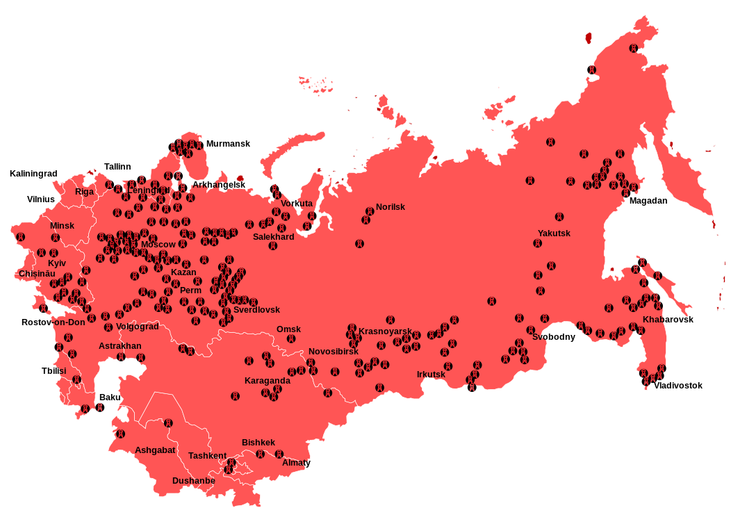
The map above, shows the locations of the Soviet Union’s Gulag forced labour camps, that existed between 1923 and 1961. This system has also become known as the Gulag Archipelago based on the title of the book written by Soviet dissident Aleksandr Solzhenitsyn.
The term Gulag is an acronym for Гла́вное управле́ние лагере́й (Glavnoye upravleniye lagerey), the “Main Camp Administration”.
While the Soviet system of labour camps goes back to 1918, following the Bolshevik revolution, the Gulag camps reached their peak under Stalin from the 1930’s into the 1950’s.
The population fell briefly during World War 2, both due to starvation and prisoners being released to fight the Nazis, but it’s been estimated that between 2.3 and 50 million people passed through the system at one point during its existence.
While the camps are often seen as being prisons designed for political prisoners, the truth is that they housed a range of prisoners from petty criminals to hardened convicts. Moreover, while they were not explicitly death camps, like those run by the Nazis, they did have significantly higher mortality rates than standard prisons.
One of the more surprising things revealed in the map above, is that majority of the camps were located in the Western part of the USSR, where the majority of the Soviet Union’s people lived, and not in Siberia. Although, the camps located in Siberia tended to be larger and obviously much harsher due to the climate and environment.
The Gulag system was extremely complex, and goes far beyond the scope of this blog to do it justice. Therefore, if you’d like to learn more, we highly recommend the following books:
- The Gulag Archipelago
- Gulag: A History
- The Unknown Gulag: The Lost World of Stalin’s Special Settlements
Find this post interesting? Please help us by sharing it:
Lee D. Cary says
How do I order a large map of the Gulag system?