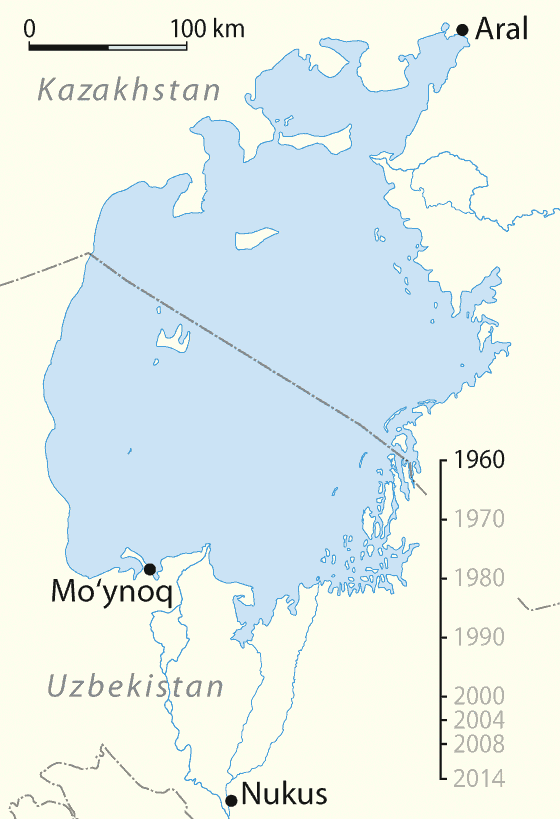
The Aral Sea was once the fourth largest body of inland water in the world with an area of 68,000 km2 but, as the map dramatically illustrates, it has now shrunk and fragmented to a mere shadow of its former self.
It lies between Kazakhstan to the north and Uzbekistan to the south. Its drainage basin also includes parts of Tajikistan, Turkmenistan, Kyrgyzstan and Afghanistan.
Its name roughly translates as “Sea of Islands” in reference to the over one thousand islands that one dotted its waters – but no more.
The two main rivers that feed the Aral Sea are the Amu Darya (also known as the Oxus), which rises in the Hindu Kush and flows (or, rather, used to flow) in at the south end and the smaller Syr Darya, which rises in the Tien Shan Mountains and flows in at the north end.
The sea lies in what is known as an endorheic basin, meaning that it has no outflows and so maintains its size by balancing inflows (river, groundwater and direct precipitation) with evaporation, making it particularly vulnerable to river diversion.
Prior to 1960 the Aral Sea had a thriving fishing industry, which in its heyday employed some 40,000 and reportedly produced one-sixth of the Soviet Union’s entire fish catch.
The deltas of the Amu Darya and Syr Darya were also home to a muskrat-trapping industry that used to yield as many as 500,000 pelts a year.
Shortly the after the Second World War, when the area was part of the U.S.S.R., the Soviet Government started to construct irrigation canals that were fed by water from the two rivers, mainly to boost cotton production.
At first this proved manageable, but around 1960 the Soviets launched a major push to further develop the cotton industry, especially in Uzbekistan and Turkmenistan, requiring a major expansion in the network of canals. By 1988 Uzbekistan had become the world’s largest exporter of cotton, or “white gold”.
However, as a consequence, evaporation began to outpace in-flows and the sea began to shrink. This came as no surprise to the government, which seemingly had made a conscious decision to sacrifice the sea in the interests of cotton production.
Indeed, Russian climatologist, Aleksandr Voeikov once dismissed the Aral Sea as a “useless evaporator” and a “mistake of nature.”
In any event, between 1960 and 2002, the surface area of the Aral Sea shrank by about 70% and its volume by 90%. In the process its surface level dropped by about 16 metres.
As can readily be seen on the map this shrinkage split the sea into a number of separate bodies of water, the two largest of which are the South Aral Sea and the North Aral Sea.
In 2002 the South Aral Sea itself split into eastern and western portions and in 2014 the eastern potion dried up completely and is now known as the Aralkum Desert, while the western portion has been reduced to a thin strip along the former edge of the southern sea.
At the same time evaporation increased the overall salinity levels almost five-fold in the waters that remained. Indeed, the salinity of the South Aral Sea is now about three times that of ordinary seawater.
Whatever the intentions of the Soviets, their treatment of the Aral Sea has had dire consequences. U.N. Secretary General Ban Ki-Moon has referred to the situation as “one of the planet’s most shocking environmental disasters”.
The combination of shrinkage and high salinity has killed off most of the sea’s natural flora and fauna and devastated its fishing and muskrat-trapping industries.
In 1960 the fishing catch amounted to 43,430 tons, while by 1980 it had fallen to zero. Former fishing towns along the original shores have become ship graveyards.
Thus the town of Moynaq in Uzbekistan, which once had a busy harbour harbor and a thriving fishing industry employing around 30,000 people, now lies many kilometers from the shore.
To make matters worse the irrigation canals were unlined so that with most of the diverted water was lost before even reaching the cotton, not only wasting water but leaching harmful salts into the soil.
This factor, along with poor soil conservation practices associated with the cotton monoculture meant that yields could only be maintained through the use of massive quantities of pesticides and fertilizer. The runoff from the fields then washed these chemicals into what was left of the Aral Sea.
As the sea receded these chemicals were left as deposits on the dry lakebed, where they were picked up by the wind as toxic dust and spread to the surrounding area causing a wide range of health issues in the local population.
These include: respiratory illnesses, tuberculosis, various cancers, birth defects, immunological disorders and liver, kidney and eye problems.
Other consequences included reduced precipitation leading to a diminished supply of fresh water and desertification of surrounding lands. There has also been an impact on the local climate with the summers becoming shorter and hotter and the winters longer and colder.
The winds have also coated surrounding glaciers with salt and dust, accelerating their rate of melting and further destabilizing the climate.
A further potential hazard is the abandoned soviet biological weapons testing facility, Aralsk-7, on the former Vozrozhdeniya Island, which is no longer an island.
In 2002, U.S. officials became so worried that, under an agreement with Uzbekistan, they provided funds and expertise to decontaminate a number of anthrax burial sites on the former island.
In June 1991, following the dismantling of the Soviet Union, Uzbekistan and Kazakhstan became independent countries. Since then there has been a marked difference between the two in their impact on the Aral Sea.
Uzbekistan has continued to emphasize cotton production as a key export, although it has also diversified into cereal crops in an effort to attain greater food self-sufficiency.
Thus on the Uzbek side the amount of water required for irrigation and the consequent impact on the Aral Sea have not changed significantly. The Amu Darya now ends at a dam, about 110 kilometres from the Aral Sea.
Moreover, Uzbekistan has embarked on extensive oil and gas exploration in areas formerly occupied by the Aral Sea and would, therefore, not be keen to see these areas under water again.
The situation in Kazakhstan is quite different. Cotton plays a very minor role in the country’s economy, which relies mostly on its oil and gas deposits near the Caspian Sea.
This has reduced the priority it places on irrigated land and has increased its willingness to revive those parts Aral Sea that are under its control. It is also worth noting that, unlike, the Amu Darya, the Syr Darya never completely lost its connection to the sea.
The local population got the ball rolling in the mid-1990s by building a makeshift dam of sand across south end of the North Aral Sea to retain all of the Syr Darya’s meagre discharge and in the process isolating it from the South Aral Sea.
In 2005 this was replaced by the permanent 13 kilometre Kok-Aral Dam as part of a joint project between the World Bank and the Government of Kazakhstan.
This $85 million project also made much needed improvements to the canals and other irrigation structures upriver from the Aral Sea, thereby greatly increasing the flow in the Syr Darya and enhancing the overall efficiency of the irrigation system.
The results have been impressive, with recovery much faster than expected. By 2008 the North Aral Sea had grown in area by 20%, its level had risen by 12 metres, its volume had increased by 68%, its salinity had dropped to 1960 levels and many native plants, migratory birds and animals had returned.
It has helped restore some of the former delta wetland ecosystems and has benefited agriculture through some increase in rainfall.
It has also brought the sea much closer to the former port city of Aralsk. There are even reports of some improvements in the health of the local population.
Freshwater fish such as pike, perch and carp, which had taken refuge in the Syr Darya, returned to the sea. In 2008 this enabled fishermen to catch roughly 1,500 tons.
Admittedly progress in restoring the fishing industry has been slow, giving mostly part-time employment to only a few hundred people.
The World Bank is considering a follow-up project to improve environmental and economic conditions further, a scheme estimated to cost $300 million. It includes returning water to the port of Aralsk and nearby villages, rehabilitating delta lakes and further improving river flows.
Unlike the North Aral Sea, the South Aral Sea is shared between the two countries so that any improvement in its status would require the cooperation of both.
However, as noted, Uzbekistan has shown little interest in its restoration and while the southern sea periodically receives excess water from the North Aral Sea through a sluice in the dam, its future remains bleak.
To read more about the Aral Sea have a look at the following books:
- Chasing the Sea: Lost Among the Ghosts of Empire in Central Asia
- Disaster By Design: The Aral Sea and its Lessons for Sustainability
- The Aral Sea: The Devastation and Partial Rehabilitation of a Great Lake
Enjoy this post? Please help us by sharing it:


Tim says
Very good overview of one of the greatest nature disasters of last century. During the Soviets era, Uzbekistan was used as a slavery state for cotton production. Students from schools and universities had to take part in picking up cotton manually (basically as a free labour) and missing on average 2 months of education each year, living in dire conditions in barracks that were designed for cattle. Lots of money went through dirty pockets under various programs ran by international organizations trying to somehow approach the problem of dying Aral sea. It was sort of obvious that the efforts were useless and the money had been feeding bureaucrats and late president Islam Karimov in particular. And that is it – Aral sea no more.